FAA INFORMATION EFFECTIVE 22 JANUARY 2026
Location
| FAA Identifier: | RIV |
| Lat/Long: | 33-52-54.9960N 117-15-32.4610W
33-52.916600N 117-15.541017W
33.8819433,-117.2590169
(estimated) |
| Elevation: | 1536 ft. / 468.2 m (surveyed) |
| Variation: | 14E (1980) |
| From city: | 6 miles SE of RIVERSIDE, CA |
| Time zone: | UTC -8 (UTC -7 during Daylight Saving Time) |
| Zip code: | 92518 |
Airport Operations
| Airport use: | Open to the public |
| Activation date: | 05/1941 |
| Control tower: | yes |
| ARTCC: | LOS ANGELES CENTER |
| FSS: | RIVERSIDE FLIGHT SERVICE STATION |
| NOTAMs facility: | RIV (NOTAM-D service available) |
| Attendance: | 0700-2300
OPR H24; OPS FM 0700-1500Z++ RQR 452 OG/CC APVL, EXC FOR KRIV BASED ALERT MSN. |
| Pattern altitude: | TFC PAT - RECTANGULAR 3000', OVERHEAD 3500'. |
| Segmented circle: | no |
| Beacon: | white-green (lighted land airport)
Operates sunset to sunrise. |
| International operations: | international airport of entry |
Airport Communications
| ATIS: | 134.75 239.05 |
| MARCH GROUND: | 121.75 335.8 |
| MARCH TOWER: | 127.65 253.5 |
| MARCH APPROACH: | 133.5 306.975 134.0 [OPR 1500-0700Z++, SAT-SUN 1500-0200Z++, CLSD HOL, OT CTC SOCAL APP/DEP] |
| SOCAL APPROACH: | 119.25 270.275 [0700-1500Z++] |
| MARCH DEPARTURE: | 133.5 306.975 134.0 [OPR 1500-0700Z++, SAT-SUN 1500-0200Z++, CLSD HOL, OT CTC SOCAL APP/DEP] |
| SOCAL DEPARTURE: | 119.25 270.275 [0700-1500Z++] |
| CLEARANCE DELIVERY: | 335.8 |
| AFRC OPS: | 252.1 |
| CLASS C: | 119.25 133.5 270.275 306.975 |
| COMD POST: | 138.45 |
| EMERG: | 121.5 243.0 |
| OPS: | 252.1 ;452 OG |
| PMSV METRO: | 239.8 |
| PTD: | 372.2 |
| RAINCROSS: | 311.0 321.0 349.4 |
| WX ASOS at RAL (10 nm NW): | 128.8 (951-352-4392) |
| WX AWOS-3 at SBD (13 nm N): | PHONE 909-382-0067 |
| WX AWOS-3PT at HMT (15 nm SE): | 118.375 (951-925-6886) |
| WX AWOS-3PT at AJO (17 nm W): | 132.175 (951-340-4764) |
| WX AWOS-3 at F70 (20 nm S): | 119.025 (951-696-1018) |
| WX ASOS at CNO (20 nm W): | PHONE 909-393-5823 |
| WX ASOS at ONT (20 nm NW): | PHONE 909-937-2186 |
- PTD RCPT EXTREMELY LTD DUE TO HI SUR TERRAIN.
- AUGMENTED AWOS IN USE. WX STATION H24, DSN 447-3602, C951-655-3602. FOR ADDN INFO OR DUR EVAC OF WX, CTC THE 25TH OWS AT DAVIS MONTHAN AFB, AZ DSN 228-6698, C520-228-6698.
Nearby radio navigation aids
| VOR radial/distance | | VOR name | | Freq | | Var |
|---|
| HDFr316/(7.3) | | HOMELAND VOR | | 112.05 | | 14E |
| RALr101/(10.5) | | RIVERSIDE VOR | | 108.60 | | 14E |
| PDZr084/13.7 | | PARADISE VORTAC | | 112.20 | | 15E |
| ELBr048/26.6 | | EL TORO VOR/DME | | 117.20 | | 14E |
| POMr099/28.8 | | POMONA VORTAC | | 110.40 | | 15E |
| OCNr357/39.3 | | OCEANSIDE VORTAC | | 115.30 | | 15E |
| NDB name | | Hdg/Dist | | Freq | | Var | | ID |
|---|
| PETIS | | 139/11.7 | | 397 | | 14E | | SB | ... -... |
Airport Services
| Fuel available: | 100LL JET-A JET-A++
100LL:FULL SVC AVBL AT FBO; SELF-SERVE UNAVBL. |
| Airframe service: | MAJOR |
| Powerplant service: | MAJOR |
| Bottled oxygen: | HIGH/LOW |
| Bulk oxygen: | HIGH/LOW |
Runway Information
Runway 14/32
| Dimensions: | 13302 x 200 ft. / 4054 x 61 m |
| Surface: | concrete, in good condition |
| Weight bearing capacity: | |
| Runway edge lights: | high intensity |
| RUNWAY 14 | | RUNWAY 32 |
| Latitude: | 33-53.785833N | | 33-51.899667N |
| Longitude: | 117-16.238167W | | 117-14.896833W |
| Elevation: | 1535.5 ft. | | 1488.3 ft. |
| Traffic pattern: | left | | left |
| Runway heading: | 135 magnetic, 149 true | | 315 magnetic, 329 true |
| Markings: | basic, in good condition | | precision, in good condition |
| Visual slope indicator: | 4-light PAPI on left (2.59 degrees glide path) | | 4-light PAPI on left (3.00 degrees glide path) |
| RVR equipment: | touchdown, midfield, rollout | | touchdown, midfield, rollout |
| Approach lights: | | | ALSF1: standard 2,400 foot high intensity approach lighting system with centerline sequenced flashers (category I) |
| Runway end identifier lights: | no | | no |
| Touchdown point: | yes, no lights | | yes, no lights |
| Instrument approach: | | | ILS |
Runway 12/30
| Dimensions: | 3061 x 100 ft. / 933 x 30 m |
| Surface: | asphalt, in poor condition
RWY 12/30 IS A SRY RWY, USED FOR MIL OPS AND MNTND BY THE MIL. IT IS IN VERY POOR COND. |
| Weight bearing capacity: | |
| Operational restrictions: | RY 12/30 CLSD TO PUBLIC-USE ONLY. |
| RUNWAY 12 | | RUNWAY 30 |
| Latitude: | 33-53.415500N | | 33-53.059167N |
| Longitude: | 117-15.640833W | | 117-15.212167W |
| Elevation: | 1519.1 ft. | | 1507.1 ft. |
| Traffic pattern: | left | | left |
| Runway heading: | 121 magnetic, 135 true | | 301 magnetic, 315 true |
| Touchdown point: | yes, no lights | | yes, no lights |
Airport Ownership and Management from official FAA records
| Ownership: | U.S. Air Force |
| Owner: | UNITED STATES AIR FORCE
2685 GRAEBER STREET, BLDG 395
MARCH ARB, CA 92518
Phone 951-655-4053 |
| Manager: | BART W. DARNELL
2685 GRAEBER STREET, BLDG 395
MARCH ARB, CA 92518
Phone 951-655-4053 |
Additional Remarks
| E60-32 | TYPE-H BAK-12B(B) (1500') |
| E60-14 | TYPE-H BAK-12B(B) (1500') |
| - | CAUTION: NSTD RWY MRK-LANDING ZONE (LZ) MARK (3500X90 PAINTED ON RWY 32 FOR BASE ASGN C17 ACFT ONLY). |
| - | TSNT ACFT NO PRACTICE APCH 2100-0700. |
| - | GEN AVN OPS PMTD DUR FBO BUS HRS. FBO BUS HRS 1400-0600Z++ MON-FRI, OPEN SAT-SUN (IF REQ PRIOR TO CLOSE OF BUS FRI) AND WILL HONOR MEDICAL REQ MADE AT ANY TIME, CALL 951-247-2111. |
| - | USE EXTREME CAUTION FOR EXTV UAS OPS IN VCNTY. |
| - | NONSTANDARD TACAN CHECKPOINT SIGNS LCTD AT RWY A AND TWY F. |
| - | MIL RMK: 24 HR PN/PPR FOR ALL TRAN ACFT, CTC AFLD MGMT OPS DSN 447-4404/2422, C951-655-4404/2422. |
| - | MIL RMK: ALL INBD PAX/CARGO ACFT MUST CTC COMD POST DSN 447-4665 24 HR PRIOR TO ARR WITH TYPE CARGO AND NR OF PAX. |
| - | CSTMS/AG/IMG - CTC AFLD MGMT OPS DSN 447-4404/2422, C951-655-4404/2422 AT LEAST 24 HR PN TO ARR RQR. LTD SVC, NO RESIDENT CSTMS AGENT, BUT ON CALL H24, DRIVING FR ONTARIO INTL. NO-NTC ACFT THAT RQR CSTMS EXP MIN 2 HR DELAY. CSTMS RQR FOLLOWING FORMS FOR ARR ACFT - CBP FORM 7507 GENERAL DECLARATION, CBP FORM 6059B CUSTOMS DECLARATION FR ALL PERS ONBOARD LCTD HTTPS://WWW.CBP.GOV/NEWSROOM/PUBLICATIONS/FORMS, PAX/CARGO MANIFEST AS APPLICABLE. AIRCREW, PAX, CARGO RQR TO REMAIN IN ACFT TIL RELEASED BY CSTMS. APV LDG RIGHTS AND OVFT EXM REQ. NOT A PORT OF ENTRY, IMG SVC EXTREMELY LTD, CASE-BY-CASE BASIS. CTC PTD 2 HR PRIOR TO LDG VIA DRCT A/G COM OR FONE PATCH. |
| - | SERVICE - OIL: JOAP AVBL ONLY ON RESERVE WKEND. O-148. |
| - | CAUTION: EXTV GLIDER, SKYDIVING, BALLOONIST AND ULTRALIGHT ACT AT PERRIS ARPT, 7 NM S OF MARCH. |
| - | RSTD: V-22 OPS RSTRD TO RWY 14/32. HELIPAD AND RWY 12/30 RSTRD TO HELS ONLY. NO FIXED WING OR V-22 ACFT PMTD DUE TO PAVEMENT RATING OF VERY POOR. |
| - | RSTD: TSNT RAMP PRKG SPOTS J1, K1 AND L1 RSTRD TO ACFT WITH WINGSPANS LESS THAN 185 FT. |
| - | RSTD: ACFT WITH WINGSPAN OF 130 FT OR GTR RSTD TO TAXI WITH OUTBOARD ENGS AT IDLE THRUST ON TWYS A AND F DUE TO SHOULDER PAVEMENT COND AND FOD POTENTIAL. |
| - | SERVICE - TRAN ALERT: OPR 1500-0700Z++ MON-SUN. |
| - | CAUTION: HEAVY MILITARY FLIGHT TRAINING. |
| - | JOINT USE AIRPORT - OWNED AND OPERATED BY US AIR FORCE/ NO CIVIL TOUCH AND GO OPS OR MANEUVERS. |
| - | AIRFIELD USE AGREEMENT WITH CIVIL ARPT AUTH (MARCH INLAND PORT ARPT AUTH) MILITARY, CIVIL COMMERCIAL AND GENERAL AVIATION(GA) USES. |
| - | GA OPS - PPR AND/OR LANDING PERMIT NOT REQ FOR USE OF CIVIL APRON AND RAMPS/FBO INF. -FREEMAN HOLDINGS 951-247-2111 / FREQS 130.075. |
| - | RY 12/30 CLSD TO PUBLIC DUE TO MUNITIONS AND EXPLOSIVES OPS IN CLOSE PROXIMITY OF RY 12/30 PER UFC & DOD REGULATIONS. |
| - | TRANSPORTATION LIMITED, PRIOR COORDINATION REQUIRED, CTC DSN 447-7787 WKND. |
Instrument Procedures
NOTE: All procedures below are presented as PDF files. If you need a reader for these files, you should download the free Adobe Reader.NOT FOR NAVIGATION. Please procure official charts for flight.
FAA instrument procedures published for use from 22 January 2026 at 0901Z to 19 February 2026 at 0900z.
STARs - Standard Terminal Arrivals |
|---|
| ARKOE ONE | |
download (164KB) |
| MARCH FOUR | |
download (143KB) |
IAPs - Instrument Approach Procedures |
|---|
| HI-ILS OR LOC Z RWY 32 | |
download (372KB) |
| ILS OR LOC X RWY 32 | |
download (182KB) |
| ILS OR LOC Y RWY 32 | |
download (195KB) |
| RNAV (GPS) RWY 14 | |
download (85KB) |
| RNAV (GPS) RWY 14 | |
download (85KB) |
| RNAV (GPS) RWY 32 | |
download (88KB) |
| RNAV (GPS) RWY 32 | |
download (88KB) |
| HI-VOR Z RWY 32 | |
download (309KB) |
| VOR Y RWY 32 | |
download (134KB) |
| HI-TACAN Z RWY 32 | |
download (330KB) |
| TACAN Y RWY 14 | |
download (148KB) |
| TACAN Y RWY 32 | |
download (165KB) |
Departure Procedures |
|---|
| SKYES FOUR | |
download (165KB) |
| NOTE: Special Take-Off Minimums/Departure Procedures apply | |
download (354KB) |
Other nearby airports with instrument procedures:
KRIR - Flabob Airport (10 nm NW)
KRAL - Riverside Airport (10 nm NW)
KSBD - San Bernardino International Airport (13 nm N)
KREI - Redlands Municipal Airport (13 nm NE)
KHMT - Hemet-Ryan Airport (15 nm SE)
KAJO - Corona Municipal Airport (17 nm W)
F70 - French Valley Airport (20 nm S)
KCNO - Chino Airport (20 nm W)
KONT - Ontario International Airport (20 nm NW)
|
|

Road maps at:
MapQuest
Bing
Google
| Aerial photo |
|---|
WARNING: Photo may not be current or correct
 Photo by Mark Holtzman
Photo taken 11-Jul-2017
looking south.
Photo by Mark Holtzman
Photo taken 11-Jul-2017
looking south.
Do you have a better or more recent aerial photo of March Air Reserve Base that you would like to share? If so, please send us your photo.
|
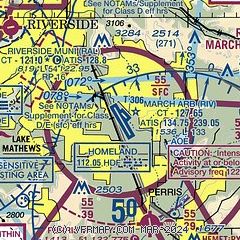
| Sectional chart |
|---|
|
CAUTION: Diagram may not be current
 Download PDF
of official airport diagram from the FAA
| Airport distance calculator |
|---|
|
|
| Sunrise and sunset |
|---|
|
Times for 26-Jan-2026
| | Local
(UTC-8) | | Zulu
(UTC) |
|---|
| Morning civil twilight | | 06:24 | | 14:24 |
| Sunrise | | 06:51 | | 14:51 |
| Sunset | | 17:13 | | 01:13 |
| Evening civil twilight | | 17:39 | | 01:39 |
|
| Current date and time |
|---|
| Zulu (UTC) | 27-Jan-2026 01:42:11 |
|---|
| Local (UTC-8) | 26-Jan-2026 17:42:11 |
|---|
|
| METAR |
|---|
| KRIV | 270055Z 07008KT 10SM FEW250 17/M12 A3019 RMK AO2A SLP221 T01651120
|
KRAL
10nm NW | 270053Z 11010KT 10SM CLR 18/M09 A3020 RMK AO2 SLP218 T01831094
|
KSBD
13nm N | 270055Z 16003KT 10SM CLR 18/M09 A3023
|
KHMT
15nm SE | 270115Z AUTO 02004KT 10SM CLR A3023 RMK AO2
|
KAJO
17nm W | 270056Z AUTO 10007KT 10SM CLR 19/M07 A3021 RMK AO2 SLP226 T01941072
|
KCNO
19nm W | 270053Z 10007KT 10SM FEW150 17/M05 A3021 RMK AO2 SLP228 T01671050
|
KONT
19nm NW | 270053Z VRB05KT 10SM FEW220 SCT250 19/M09 A3020 RMK AO2 SLP222 T01941094 $
|
KF70
20nm S | 270115Z AUTO 10009KT 10SM CLR 16/M09 A3022 RMK AO2
|
|
| TAF |
|---|
| KRIV | 262000Z 2620/2802 08009KT 9999 SCT150 BKN200 510009 QNH3022INS WND 050V150 TEMPO 2620/2701 08012G18KT BECMG 2705/2706 08006KT 9999 FEW150 SCT200 510006 QNH3020INS BECMG 2717/2718 08009KT 9999 SKC 510005 QNH3018INS WND 040V140 BECMG 2721/2722 33009KT 9999 SKC QNH3017INS WND 280V020 TX21/2622Z TN00/2714Z
|
KSBD
13nm N | 261727Z 2618/2718 VRB05KT P6SM BKN200
|
KONT
19nm NW | 261727Z 2618/2724 VRB05KT P6SM BKN200
|
|
| NOTAMs |
|---|
NOTAMs are issued by the DoD/FAA and will open in a separate window not controlled by AirNav.
|
|


