FAA INFORMATION EFFECTIVE 30 OCTOBER 2025
Location
| FAA Identifier: | RQB |
| Lat/Long: | 43-43-21.5000N 085-30-14.6000W
43-43.358333N 085-30.243333W
43.7226389,-85.5040556
(estimated) |
| Elevation: | 989.8 ft. / 301.7 m (surveyed) |
| Variation: | 05W (2000) |
| From city: | 2 miles NW of BIG RAPIDS, MI |
| Time zone: | UTC -5 (UTC -4 during Daylight Saving Time) |
| Zip code: | 49307 |
Airport Operations
| Airport use: | Open to the public |
| Activation date: | 04/1940 |
| Control tower: | no |
| ARTCC: | MINNEAPOLIS CENTER |
| FSS: | LANSING FLIGHT SERVICE STATION |
| NOTAMs facility: | RQB (NOTAM-D service available) |
| Attendance: | SAT 0800-1500, ALL MON-FRI 0800-1700 |
| Wind indicator: | lighted |
| Segmented circle: | no |
| Lights: | ACTVT REIL RWY 09 & 27; PAPI RWY 09 & 27; MIRL RWY 09/27 & 14/32 - CTAF. |
| Beacon: | white-green (lighted land airport)
Operates sunset to sunrise. |
| Landing fee: | no, LDG FEE FOR COML ACFT WAIVED WITH MNM FUEL PURCHASE. |
Airport Communications
| CTAF/UNICOM: | 122.8 |
| WX AWOS-3P: | 125.875 (231-796-0884) |
- APCH/DEP SVC PRVDD BY MINNEAPOLIS ARTCC ON FREQS 120.85/322.35 (WHITE CLOUD RCAG).
Nearby radio navigation aids
| VOR radial/distance | | VOR name | | Freq | | Var |
|---|
| MOPr285/33.8 | | MOUNT PLEASANT VOR/DME | | 110.60 | | 05W |
Airport Services
| Fuel available: | 100LL JET-A+
100LL:AVBL H24 SELF SVC.
A+:SINGLE POINT & OVERWING AVBL. |
| Parking: | hangars and tiedowns |
| Airframe service: | MAJOR |
| Powerplant service: | MAJOR |
Runway Information
Runway 9/27
| Dimensions: | 4300 x 75 ft. / 1311 x 23 m |
| Surface: | asphalt/porous friction courses, in good condition |
| Weight bearing capacity: | | PCN 20 /F/A/Y/T | | Single wheel: | 62.0 | | Double wheel: | 87.0 |
|
| Runway edge lights: | medium intensity |
| RUNWAY 9 | | RUNWAY 27 |
| Latitude: | 43-43.472620N | | 43-43.468953N |
| Longitude: | 085-30.991908W | | 085-30.016140W |
| Elevation: | 989.5 ft. | | 944.6 ft. |
| Traffic pattern: | left | | left |
| Runway heading: | 095 magnetic, 090 true | | 275 magnetic, 270 true |
| Markings: | nonprecision, in good condition | | nonprecision, in good condition |
| Visual slope indicator: | 2-light PAPI on left (3.33 degrees glide path)
PAPI UNUSBL BYD 5 DEGS RIGHT OF CNTRLN. | | 4-light PAPI on left (3.08 degrees glide path) |
| Runway end identifier lights: | yes | | yes |
| Touchdown point: | yes, no lights | | yes, no lights |
Runway 14/32
| Dimensions: | 2699 x 75 ft. / 823 x 23 m |
| Surface: | asphalt, in good condition |
| Weight bearing capacity: | | PCN 10 /F/A/Y/T | | Single wheel: | 37.0 | | Double wheel: | 56.0 |
|
| Runway edge lights: | medium intensity |
| RUNWAY 14 | | RUNWAY 32 |
| Latitude: | 43-43.356037N | | 43-43.001423N |
| Longitude: | 085-30.013117W | | 085-29.644150W |
| Elevation: | 932.4 ft. | | 924.9 ft. |
| Traffic pattern: | left | | left |
| Runway heading: | 148 magnetic, 143 true | | 328 magnetic, 323 true |
| Markings: | basic, in good condition | | basic, in good condition |
| Runway end identifier lights: | | | no |
| Touchdown point: | yes, no lights | | yes, no lights |
Airport Ownership and Management from official FAA records
| Ownership: | Publicly-owned |
| Owner: | CITY OF BIG RAPIDS
CITY HALL, 226 N MICHIGAN AVE
BIG RAPIDS, MI 49307-1489
Phone 231-592-4045 |
| Manager: | STEVE SCHROEDER, FIRE CHIEF
21325 18 MILE RD
BIG RAPIDS, MI 49307-9721
Phone 231-796-5600
CITY HALL 231-679-1583. |
Additional Remarks
| - | BIRDS & DEER ON & INVOF ARPT. |
| - | ADMIN BLDG ACES: PRESS 5, THEN 3 & 2 SIMUL, THEN 1. |
| - | FOR CD CTC MINNEAPOLIS ARTCC AT 651-463-5588. |
Instrument Procedures
NOTE: All procedures below are presented as PDF files. If you need a reader for these files, you should download the free Adobe Reader.NOT FOR NAVIGATION. Please procure official charts for flight.
FAA instrument procedures published for use from 30 October 2025 at 0901Z to 27 November 2025 at 0900Z.
IAPs - Instrument Approach Procedures |
|---|
| RNAV (GPS) RWY 27 | |
download (215KB) |
| NOTE: Special Alternate Minimums apply | |
download (138KB) |
| NOTE: Special Take-Off Minimums/Departure Procedures apply | |
download (248KB) |
Other nearby airports with instrument procedures:
7D3 - Baldwin Municipal Airport (17 nm NW)
13C - Lakeview Airport/Griffith Field (19 nm SE)
KFFX - Fremont Municipal Airport (27 nm SW)
KCAD - Wexford County Airport (33 nm N)
48D - Clare Municipal Airport (34 nm E)
|
|

Road maps at:
MapQuest
Bing
Google
| Aerial photo |
|---|
WARNING: Photo may not be current or correct
 Photo taken 14-Aug-2014
looking east.
Photo taken 14-Aug-2014
looking east.
Do you have a better or more recent aerial photo of Roben-Hood Airport that you would like to share? If so, please send us your photo.
|
| Sectional chart |
|---|
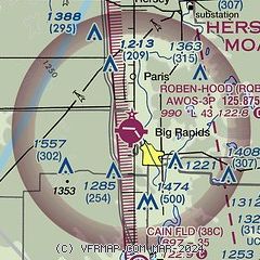
|
| Airport distance calculator |
|---|
|
|
| Sunrise and sunset |
|---|
|
Times for 16-Nov-2025
| | Local
(UTC-5) | | Zulu
(UTC) |
|---|
| Morning civil twilight | | 07:08 | | 12:08 |
| Sunrise | | 07:39 | | 12:39 |
| Sunset | | 17:15 | | 22:15 |
| Evening civil twilight | | 17:46 | | 22:46 |
|
| Current date and time |
|---|
| Zulu (UTC) | 17-Nov-2025 00:12:42 |
|---|
| Local (UTC-5) | 16-Nov-2025 19:12:42 |
|---|
|
| METAR |
|---|
| KRQB | 162355Z AUTO 29007KT 10SM FEW050 02/M06 A2985 RMK AO2 10050 20017
|
|
| TAF |
|---|
KMBL
46nm NW | 161725Z 1618/1718 32014G23KT P6SM BKN035 FM170500 32014KT P6SM FEW070 SCT250 FM171200 32010KT P6SM SCT250
|
KMKG
46nm SW | 161740Z 1618/1718 31012G24KT P6SM SCT035 FM170300 32008G19KT P6SM SKC FM171200 33007KT P6SM SKC
|
|
| NOTAMs |
|---|
NOTAMs are issued by the DoD/FAA and will open in a separate window not controlled by AirNav.
|
|

