FAA INFORMATION EFFECTIVE 14 MAY 2026
Location
| FAA Identifier: | S36 |
| Lat/Long: | 47-20-13.5480N 122-06-12.7310W
47-20.225800N 122-06.212183W
47.3370967,-122.1035364
(estimated) |
| Elevation: | 472 ft. / 144 m (estimated) |
| Variation: | 20E (1985) |
| From city: | 1 mile SSE of COVINGTON, WA |
| Time zone: | UTC -7 (UTC -8 during Standard Time) |
| Zip code: | 98042 |
Airport Operations
| Airport use: | Open to the public |
| Activation date: | 03/1965 |
| Control tower: | no |
| ARTCC: | SEATTLE CENTER |
| FSS: | SEATTLE FLIGHT SERVICE STATION |
| NOTAMs facility: | SEA (NOTAM-D service available) |
| Attendance: | 0900-1700 |
| Wind indicator: | lighted |
| Segmented circle: | no |
| Beacon: | white-green (lighted land airport)
Operates sunset to sunrise. |
Airport Communications
| CTAF/UNICOM: | 123.0 |
| WX ASOS at RNT (10 nm NW): | 126.95 (425-255-6080) |
| WX ASOS at SEA (11 nm NW): | PHONE 206-214-2592 |
| WX ASOS at BFI (14 nm NW): | PHONE 206-658-6435 |
| WX AWOS-3 at PLU (16 nm SW): | 128.575 (253-848-2748) |
| WX ASOS at TCM (19 nm SW): | PHONE 253-982-3434 |
| WX ASOS at TIW (20 nm W): | PHONE 253-858-6507 |
Nearby radio navigation aids
| VOR radial/distance | | VOR name | | Freq | | Var |
|---|
| SEAr106/10.2 | | SEATTLE VORTAC | | 116.80 | | 19E |
| PAEr149/35.7 | | PAINE VOR/DME | | 110.60 | | 20E |
| OLMr037/39.3 | | OLYMPIA VORTAC | | 113.40 | | 19E |
Airport Services
| Fuel available: | 100LL
100LL:24 HR CREDIT CARD FUEL AVBL. |
| Parking: | tiedowns |
| Airframe service: | MAJOR |
| Powerplant service: | MAJOR |
| Bottled oxygen: | NONE |
| Bulk oxygen: | NONE |
Runway Information
Runway 16/34
| Dimensions: | 3288 x 40 ft. / 1002 x 12 m |
| Surface: | asphalt, in good condition |
| Weight bearing capacity: | |
| Runway edge lights: | low intensity |
| Runway edge markings: | MARKINGS FADED. |
| RUNWAY 16 | | RUNWAY 34 |
| Latitude: | 47-20.492850N | | 47-19.958750N |
| Longitude: | 122-06.274483W | | 122-06.149883W |
| Elevation: | 472.0 ft. | | 472.0 ft. |
| Traffic pattern: | left | | left |
| Displaced threshold: | no | | 281 ft. |
| Markings: | NSTD, in poor condition | | NSTD, in poor condition |
| Obstructions: | 76 ft. trees, 901 ft. from runway, 9:1 slope to clear
TREES IN PRIM SFC, PARKED ACFT IN PRIM SFC BOTH SIDES OF RWY AND 3 FT SIGN, 92 FT LEFT, 27 FT FROM THR. | | 107 ft. trees, 1560 ft. from runway, 12:1 slope to clear
+95 FT TREES IN PRI SFC 0-200 FT FM THR, 120 FT RIGHT. |
Airport Ownership and Management from official FAA records
| Ownership: | Privately-owned |
| Owner: | CREST AIRFIELD, LLC
29300 179 PLACE SE, PO BOX 7282
COVINGTON, WA 98042-7282
Phone 425-533-9651
OTR CTC: AIRFIELDMANAGER@CRESTAIRFIELD.AERO. |
| Manager: | JEFF MILLER
29300 179TH PLACE SE, P.O. BOX 7282
COVINGTON, WA 98042-7282
Phone 425-533-9651
AMGR OTR CTC: AIRFIELDMANAGER@CRESTAIRFIELD.AERO. |
Additional Remarks
| - | TREES BOTH SIDES OF RWY IN TRSN SFC. |
| - | TREES ON BOTH SIDES OF RWY 15/33. |
| - | NIGHT OPS USE RWY 15, WIND AND WX PMTG. |
| - | ARPT CLSD WHEN SNOW ON RWY. |
| - | FOR CD CTC SEATTLE APCH AT 206-214-4723. |
| - | TGLS PROHIBITED. |
Instrument Procedures
There are no published instrument procedures at S36.
Some nearby airports with instrument procedures:
S50 - Auburn Municipal Airport (5 nm W)
KRNT - Renton Municipal Airport (10 nm NW)
KSEA - Seattle-Tacoma International Airport (11 nm NW)
KBFI - Boeing Field/King County International Airport (14 nm NW)
KPLU - Pierce County Airport/Thun Field (16 nm SW)
KTCM - McChord Field Airport (Joint Base Lewis-McChord) (19 nm SW)
KTIW - Tacoma Narrows Airport (20 nm W)
|
|

Road maps at:
MapQuest
Bing
Google
| Aerial photo |
|---|
WARNING: Photo may not be current or correct
 Photo taken 22-Feb-2015
looking north.
Photo taken 22-Feb-2015
looking north.
Do you have a better or more recent aerial photo of Crest Airfield that you would like to share? If so, please send us your photo.
|
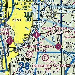
| Sectional chart |
|---|
|
| Airport distance calculator |
|---|
|
|
| Sunrise and sunset |
|---|
|
Times for 27-May-2026
| | Local
(UTC-7) | | Zulu
(UTC) |
|---|
| Morning civil twilight | | 04:42 | | 11:42 |
| Sunrise | | 05:20 | | 12:20 |
| Sunset | | 20:51 | | 03:51 |
| Evening civil twilight | | 21:29 | | 04:29 |
|
| Current date and time |
|---|
| Zulu (UTC) | 27-May-2026 13:50:31 |
|---|
| Local (UTC-7) | 27-May-2026 06:50:31 |
|---|
|
| METAR |
|---|
KRNT
11nm NW | 271253Z AUTO 00000KT 10SM CLR 10/09 A2997 RMK AO2 SLP155 T01000089
|
KSEA
11nm NW | 271253Z 00000KT 10SM FEW060 SCT220 10/08 A2997 RMK AO2 SLP155 T01000083
|
KBFI
15nm NW | 271253Z 00000KT 10SM SCT200 11/08 A2997 RMK AO2 SLP148 T01060083
|
KPLU
16nm SW | 271335Z AUTO 00000KT 9SM -DZ CLR 09/09 A2997 RMK AO2
|
KTCM
20nm SW | 271255Z AUTO 19004KT 10SM CLR 07/06 A2996 RMK AO2 SLP149 T00670060 $
|
KTIW
20nm W | 271253Z AUTO 00000KT 10SM CLR 09/08 A2997 RMK AO2 SLP147 T00940083
|
|
| TAF |
|---|
KSEA
11nm NW | 271123Z 2712/2818 VRB04KT P6SM SCT050 SCT200 FM271600 34006KT P6SM FEW050 SCT200 FM271900 34011KT P6SM SCT200 FM280400 36007KT P6SM SCT200 FM281100 01004KT P6SM SCT200
|
KBFI
15nm NW | 271123Z 2712/2812 VRB03KT P6SM SCT050 SCT200 FM271700 32004KT P6SM FEW050 SCT200 FM272000 33008KT P6SM SCT200 FM280600 VRB04KT P6SM SCT200
|
KTCM
20nm SW | 270500Z 2705/2811 01005KT 9999 SCT045 QNH2995INS BECMG 2708/2709 VRB05KT 8000 BR FEW002 QNH2995INS BECMG 2716/2717 31005KT 9999 NSW FEW080 QNH2995INS BECMG 2718/2719 03012G18KT 9999 SCT100 QNH2984INS BECMG 2805/2806 01005KT 9999 SCT090 QNH2984INS TX23/2721Z TN08/2713Z
|
|
| NOTAMs |
|---|
NOTAMs are issued by the DoD/FAA and will open in a separate window not controlled by AirNav.
|
|

