FAA INFORMATION EFFECTIVE 16 APRIL 2026
Location
| FAA Identifier: | SBN |
| Lat/Long: | 41-42-29.6060N 086-19-02.4150W
41-42.493433N 086-19.040250W
41.7082239,-86.3173375
(estimated) |
| Elevation: | 798.4 ft. / 243.4 m (surveyed) |
| Variation: | 05W (2025) |
| From city: | 3 miles NW of SOUTH BEND, IN |
| Time zone: | UTC -4 (UTC -5 during Standard Time) |
| Zip code: | 46628 |
Airport Operations
| Airport use: | Open to the public |
| Activation date: | 04/1940 |
| Control tower: | yes |
| ARTCC: | CHICAGO CENTER |
| FSS: | TERRE HAUTE FLIGHT SERVICE STATION |
| NOTAMs facility: | SBN (NOTAM-D service available) |
| Attendance: | CONTINUOUS |
| Wind indicator: | lighted |
| Segmented circle: | no |
| Lights: | WHEN ATCT CLSD, TO INCR INTST AND ACTVT MALSF RWY 09R; MALSR RWY 27L; HIRL RWY 09R/27L; MIRL RWY 18/36 AND ALL TWYS - CTAF. |
| Beacon: | white-green (lighted land airport)
Operates sunset to sunrise. |
| Fire and rescue: | ARFF index B |
| International operations: | 24 HR PPR FOR CBP - 574-232-9650; WKEND SVC CALL BFR
1600 FRI. |
Airport Communications
| CTAF: | 135.675 |
| ATIS: | 120.675 |
| WX ASOS: | 120.675 (574-200-0869) |
| SOUTH BEND GROUND: | 121.7 [0530-0000 SUN-FRI, 0530-2345 SAT.] |
| SOUTH BEND TOWER: | 135.675 257.8 [0530-0000 SUN-FRI, 0530-2345 SAT.] |
| SOUTH BEND APPROACH: | 118.55 ;270-099 132.05 ;100-269 257.8 [0530-0000 SUN-FRI, 0530-2345 SAT.] |
| CHICAGO ARTCC APPROACH: | 124.1 ;100-269 [0000-0530 SUN-FRI, 2345-0530 SAT.] |
| SOUTH BEND DEPARTURE: | 118.55 ;270-099 132.05 ;100-269 257.8 [0530-0000 SUN-FRI, 0530-2345 SAT.] |
| CHICAGO ARTCC DEPARTURE: | 124.1 ;100-269 [0000-0530 SUN-FRI, 2345-0530 SAT.] |
| CLEARANCE DELIVERY: | 121.9 |
| CLASS C: | 118.55 ;270-099 132.05 ;100-269 257.8 |
| CLASS C/S: | 124.1 ;100-269 |
| IC: | 118.55 ;270-099 |
| WX AWOS-3PT at EKM (14 nm E): | 124.475 (574-264-9002) |
- APCH/DEP SVC PRVDD BY CHICAGO ARTCC ON REMOTED SOUTH BEND APCH CTL FREQ 118.55 & CHICAGO ARTCC FREQ 307.175 (GOSHEN RCAG) WHEN APCH CTL CLSD.
Nearby radio navigation aids
| VOR radial/distance | | VOR name | | Freq | | Var |
|---|
| GIJr179/3.6 | | GIPPER VORTAC | | 115.40 | | 00E |
| NDB name | | Hdg/Dist | | Freq | | Var | | ID |
|---|
| MISHA | | 277/4.4 | | 341 | | 05W | | SB | ... -... |
Airport Services
| Fuel available: | 100LL JET-A |
| Parking: | hangars and tiedowns |
| Airframe service: | MAJOR |
| Powerplant service: | MAJOR |
| Bottled oxygen: | HIGH/LOW |
| Bulk oxygen: | HIGH/LOW |
Runway Information
Runway 9R/27L
| Dimensions: | 8412 x 150 ft. / 2564 x 46 m |
| Surface: | asphalt/grooved, in good condition |
| Weight bearing capacity: | | Single wheel: | 120.0 | | Double wheel: | 193.0 | | Double tandem: | 313.0 |
|
| Runway edge lights: | high intensity |
| RUNWAY 9R | | RUNWAY 27L |
| Latitude: | 41-42.259690N | | 41-42.288628N |
| Longitude: | 086-19.764968W | | 086-17.917083W |
| Elevation: | 789.9 ft. | | 769.0 ft. |
| Traffic pattern: | left | | left |
| Runway heading: | 094 magnetic, 089 true | | 274 magnetic, 269 true |
| Declared distances: | TORA:8412 TODA:8412 ASDA:8412 LDA:8412 | | TORA:8412 TODA:8412 ASDA:8412 LDA:8412 |
| Markings: | precision, in good condition | | precision, in good condition |
| Visual slope indicator: | 4-light PAPI on left (3.00 degrees glide path) | | 4-light PAPI on left (3.00 degrees glide path) |
| RVR equipment: | touchdown | | touchdown, rollout |
| Approach lights: | MALSF: 1,400 foot medium intensity approach lighting system with sequenced flashers | | MALSR: 1,400 foot medium intensity approach lighting system with runway alignment indicator lights |
| Runway end identifier lights: | no | | no |
| Touchdown point: | yes, no lights | | yes, no lights |
| Instrument approach: | ILS | | ILS |
| Obstructions: | 60 ft. tree, 1492 ft. from runway, 666 ft. right of centerline, 21:1 slope to clear | | 36 ft. tree, 1741 ft. from runway, 588 ft. right of centerline, 42:1 slope to clear |
Runway 18/36
| Dimensions: | 7101 x 150 ft. / 2164 x 46 m |
| Surface: | asphalt/grooved, in good condition |
| Weight bearing capacity: | | Single wheel: | 118.0 | | Double wheel: | 186.0 | | Double tandem: | 326.0 |
|
| Runway edge lights: | medium intensity |
| RUNWAY 18 | | RUNWAY 36 |
| Latitude: | 41-43.125248N | | 41-41.956335N |
| Longitude: | 086-19.163752W | | 086-19.129550W |
| Elevation: | 798.4 ft. | | 759.4 ft. |
| Traffic pattern: | left | | left |
| Runway heading: | 184 magnetic, 179 true | | 004 magnetic, 359 true |
| Declared distances: | TORA:7101 TODA:7101 ASDA:7101 LDA:7101 | | TORA:7101 TODA:7101 ASDA:7101 LDA:7101 |
| Markings: | nonprecision, in good condition | | nonprecision, in good condition |
| Visual slope indicator: | 4-light PAPI on left (3.00 degrees glide path) | | 4-light PAPI on left (3.00 degrees glide path) |
| Runway end identifier lights: | no | | no |
| Touchdown point: | yes, no lights | | yes, no lights |
| Obstructions: | 69 ft. tree, 2726 ft. from runway, 442 ft. right of centerline, 36:1 slope to clear | | 80 ft. tree, 1880 ft. from runway, 210 ft. right of centerline, 20:1 slope to clear |
Runway 9L/27R
| Dimensions: | 4300 x 75 ft. / 1311 x 23 m |
| Surface: | asphalt, in good condition |
| Weight bearing capacity: | | Single wheel: | 32.5 | | Double wheel: | 49.0 |
|
| Runway edge lights: | medium intensity |
| Operational restrictions: | RWY 09L/27R NOT AVBL FOR PART 121/PART 380 OPS WITH SKED PAX CARRYING OPS MORE THAN 9 PAX SEATS AND NON-SKED PAX CARRYING OPS MORE THAN 30 PAX SEATS. CLSD WHEN TWR CLSD; WT RSTRD 45000 SINGLE & 60000 DUAL. |
| RUNWAY 9L | | RUNWAY 27R |
| Latitude: | 41-42.836543N | | 41-42.851578N |
| Longitude: | 086-19.726670W | | 086-18.782037W |
| Elevation: | 788.0 ft. | | 780.2 ft. |
| Traffic pattern: | left | | left |
| Runway heading: | 094 magnetic, 089 true | | 274 magnetic, 269 true |
| Markings: | nonprecision, in good condition | | nonprecision, in good condition |
| Visual slope indicator: | 2-light PAPI on left (3.00 degrees glide path) | | 2-light PAPI on left (3.00 degrees glide path) |
| Touchdown point: | yes, no lights | | yes, no lights |
| Obstructions: | 62 ft. tree, 1541 ft. from runway, 93 ft. right of centerline, 21:1 slope to clear | | 51 ft. tree, 1226 ft. from runway, 368 ft. right of centerline, 20:1 slope to clear
APCH SLOPE 21:1 DUE TO 92 FT HIGH TENSION WIRES 2160 FT FM RWY END; 394 FT R OF CNTRLN. |
Airport Ownership and Management from official FAA records
| Ownership: | Publicly-owned |
| Owner: | ST JOSEPH COUNTY ARPT AUTHORITY
4477 PROGRESS DRIVE
SOUTH BEND, IN 46628
Phone 574-282-4590 |
| Manager: | MICHAEL A. DAIGLE
4477 PROGRESS DRIVE
SOUTH BEND, IN 46628
Phone 574-282-4590 |
Additional Remarks
| A39-18/36 | PCR VALUE: 450/F/B/X/T |
| A39-09R/27L | PCR VALUE: 410/F/B/X/U |
| A39-09L/27R | PCR VALUE: 430/F/B/X/T |
| A30A-27R | BE ALERT DURG RIGHT BASE; HIGH TENSION WIRES AER. |
| - | BIRDS ON & INVOF ARPT. |
| - | FOR FUEL & SVCS - 122.95 OR 131.7. |
| - | FOR CD CTC SOUTH BEND APCH AT 574-251-2609. WHEN SOUTH BEND APCH CLSD, FOR CD CTC CHICAGO ARTCC AT 630-906-8921. |
| - | ACR RAMP RSTRD TO SKED COML & WINGSPAN GTR THAN 100 FT; ALL OTR 24 HR PPR. |
| - | INDEX C AVAILABLE UPON REQ |
| - | TWYS J, J1 & J2 CLSD INDEF. |
| - | TWY T NOT AVBL TO ACR OPNS WITH MORE THAN 9 PAX SEATS OR UNSKED ACR AT LEAST 31 PAX SEATS. |
| - | LINE OF SIGHT BTN RWY INTS RSTRD. |
Instrument Procedures
NOTE: All procedures below are presented as PDF files. If you need a reader for these files, you should download the free Adobe Reader.NOT FOR NAVIGATION. Please procure official charts for flight.
FAA instrument procedures published for use from 16 April 2026 at 0901Z to 14 May 2026 at 0900Z.
IAPs - Instrument Approach Procedures |
|---|
| ILS OR LOC RWY 09R | |
download (224KB) |
| ILS OR LOC RWY 27L | |
download (216KB) |
| ILS RWY 27L (SA CAT I - II) | |
download (207KB) |
| RNAV (GPS) RWY 09L **CHANGED** | |
download (208KB) |
| RNAV (GPS) RWY 09R **CHANGED** | |
download (241KB) |
| RNAV (GPS) RWY 18 **CHANGED** | |
download (206KB) |
| RNAV (GPS) RWY 27L | |
download (211KB) |
| RNAV (GPS) RWY 27R | |
download (197KB) |
| RNAV (GPS) RWY 36 | |
download (200KB) |
| VOR RWY 18 | |
download (208KB) |
| NOTE: Special Alternate Minimums apply **CHANGED** | |
download (150KB) |
| NOTE: Special Take-Off Minimums/Departure Procedures apply | |
download (480KB) |
Other nearby airports with instrument procedures:
3TR - Jerry Tyler Memorial Airport (9 nm NE)
KEKM - Elkhart Municipal Airport (14 nm E)
C20 - Andrews University Airpark (15 nm N)
C91 - Dowagiac Municipal Airport (19 nm NE)
KPPO - La Porte Municipal Airport (20 nm SW)
|
|

Road maps at:
MapQuest
Bing
Google
| Aerial photo |
|---|
WARNING: Photo may not be current or correct
 Photo by AJ Coady
Photo taken 06-Apr-2012
from 5500MSL looking east.
Photo by AJ Coady
Photo taken 06-Apr-2012
from 5500MSL looking east.
Do you have a better or more recent aerial photo of South Bend International Airport that you would like to share? If so, please send us your photo.
|
| Sectional chart |
|---|
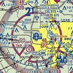
|
CAUTION: Diagram may not be current
 Download PDF
of official airport diagram from the FAA
| Airport distance calculator |
|---|
|
|
| Sunrise and sunset |
|---|
|
Times for 18-Apr-2026
| | Local
(UTC-4) | | Zulu
(UTC) |
|---|
| Morning civil twilight | | 06:32 | | 10:32 |
| Sunrise | | 07:02 | | 11:02 |
| Sunset | | 20:28 | | 00:28 |
| Evening civil twilight | | 20:57 | | 00:57 |
|
| Current date and time |
|---|
| Zulu (UTC) | 18-Apr-2026 22:02:50 |
|---|
| Local (UTC-4) | 18-Apr-2026 18:02:50 |
|---|
|
| METAR |
|---|
| KSBN | 182154Z 30015G27KT 10SM CLR 10/00 A2993 RMK AO2 PK WND 27030/2102 SLP135 T01000000 $
|
KEKM
14nm E | 182155Z AUTO 29011G21KT 9SM CLR 10/M00 A2991 RMK AO2 T01001003 $
|
|
| TAF |
|---|
| KSBN | 181721Z 1818/1918 29012KT P6SM BKN025 FM181900 28011KT P6SM SCT030 BKN070 FM190300 27008KT P6SM SCT080 FM191600 29012G21KT P6SM SCT200
|
|
| NOTAMs |
|---|
NOTAMs are issued by the DoD/FAA and will open in a separate window not controlled by AirNav.
|
|


