FAA INFORMATION EFFECTIVE 27 NOVEMBER 2025
Location
| FAA Identifier: | SFM |
| Lat/Long: | 43-23-37.7000N 070-42-28.8000W
43-23.628333N 070-42.480000W
43.3938056,-70.7080000
(estimated) |
| Elevation: | 244.1 ft. / 74.4 m (surveyed) |
| Variation: | 17W (1990) |
| From city: | 4 miles SE of SANFORD, ME |
| Time zone: | UTC -5 (UTC -4 during Daylight Saving Time) |
| Zip code: | 04073 |
Airport Operations
| Airport use: | Open to the public |
| Activation date: | 04/1940 |
| Control tower: | no |
| ARTCC: | BOSTON CENTER |
| FSS: | BANGOR FLIGHT SERVICE STATION |
| NOTAMs facility: | SFM (NOTAM-D service available) |
| Attendance: | OCT-MAY 0700-1700, JUN-SEPT 0700-1900 |
| Wind indicator: | lighted |
| Segmented circle: | yes |
| Lights: | ACTVT ODALS RWY 25; REIL RWY 07; PAPI RWY 07 & 25; HIRL 07/25; MIRL 14/32; TWY LGTS - CTAF. TWY LGTS INOP DALGT HRS. |
| Beacon: | white-green (lighted land airport)
Operates sunset to sunrise. |
Airport Communications
| CTAF/UNICOM: | 123.075 |
| WX AWOS-3PT: | 120.025 (207-324-1958) |
| PORTLAND APPROACH: | 119.75 [0545-0000] |
| PORTLAND DEPARTURE: | 119.75 [0545-0000] |
| CLEARANCE DELIVERY: | 121.725 |
| WX ASOS at DAW (12 nm SW): | 135.275 (603-332-7814) |
- APCH/DEP SVC PRVDD BY BOSTON ARTCC ON FREQS 128.2/263.05 (WATERBORO RCAG) WHEN PORTLAND APCH CTL CLSD.
Nearby radio navigation aids
| VOR radial/distance | | VOR name | | Freq | | Var |
|---|
| ENEr262/4.5 | | KENNEBUNK VOR/DME | | 117.10 | | 17W |
| CONr090/39.3 | | CONCORD VOR/DME | | 112.90 | | 15W |
| NDB name | | Hdg/Dist | | Freq | | Var | | ID |
|---|
| ROLLINS | | 043/11.7 | | 260 | | 16W | | ESG | . ... --. |
Airport Services
| Fuel available: | 100LL JET-A MOGAS |
| Parking: | hangars and tiedowns |
| Airframe service: | MAJOR |
| Powerplant service: | MAJOR |
| Bottled oxygen: | HIGH/LOW |
| Bulk oxygen: | NONE |
Runway Information
Runway 7/25
| Dimensions: | 6389 x 100 ft. / 1947 x 30 m |
| Surface: | asphalt/grooved, in good condition |
| Weight bearing capacity: | | Single wheel: | 65.0 | | Double wheel: | 100.0 |
|
| Runway edge lights: | high intensity |
| RUNWAY 7 | | RUNWAY 25 |
| Latitude: | 43-23.200188N | | 43-23.751685N |
| Longitude: | 070-43.184602W | | 070-41.957067W |
| Elevation: | 240.5 ft. | | 232.1 ft. |
| Traffic pattern: | left | | left |
| Runway heading: | 075 magnetic, 058 true | | 255 magnetic, 238 true |
| Displaced threshold: | no | | 388 ft. |
| Markings: | precision, in good condition | | nonprecision, in good condition |
| Visual slope indicator: | 4-light PAPI on left (3.00 degrees glide path) | | 4-light PAPI on left (3.00 degrees glide path) |
| Approach lights: | | | ODALS: omnidirectional approach lighting system |
| Runway end identifier lights: | yes | | |
| Touchdown point: | yes, no lights | | yes, no lights |
| Instrument approach: | ILS | | |
| Obstructions: | 30 ft. tree, 1074 ft. from runway, 278 ft. left of centerline, 29:1 slope to clear
APCH RATIO 49:1 AT DTHR. | | 18 ft. pline, 695 ft. from runway, 460 ft. right of centerline, 27:1 slope to clear |
Runway 14/32
| Dimensions: | 4999 x 100 ft. / 1524 x 30 m |
| Surface: | asphalt, in good condition |
| Weight bearing capacity: | |
| Runway edge lights: | medium intensity |
| RUNWAY 14 | | RUNWAY 32 |
| Latitude: | 43-24.020577N | | 43-23.622750N |
| Longitude: | 070-42.858413W | | 070-41.870485W |
| Elevation: | 244.0 ft. | | 230.7 ft. |
| Traffic pattern: | left | | left |
| Runway heading: | 136 magnetic, 119 true | | 316 magnetic, 299 true |
| Displaced threshold: | 885 ft. | | no |
| Markings: | basic, in good condition | | basic, in good condition |
| Visual slope indicator: | 4-light PAPI on left (4.00 degrees glide path) | | 4-light PAPI on left (3.00 degrees glide path) |
| Runway end identifier lights: | no | | no |
| Touchdown point: | yes, no lights | | yes, no lights |
| Obstructions: | 68 ft. tree, 516 ft. from runway, 120 ft. left of centerline, 4:1 slope to clear
APCH RATIO 20:1 AT DTHR. | | none |
Airport Ownership and Management from official FAA records
| Ownership: | Publicly-owned |
| Owner: | CITY OF SANFORD
919 MAIN ST
SANFORD, ME 04073
Phone (207) 324-9173 |
| Manager: | M. ALLISON NAVIA
9 PRESIDENTIAL LN
SANFORD, ME 04073
Phone 207-324-3172 |
Additional Remarks
| - | WILDLIFE ON & INVOF ARPT. |
| - | HIGH VOL FIXED AND ROTARY WING FLT TRNG IN VCNTY. |
| - | CALM WIND PREFERRED RWY 32. |
| - | 24 HR FUEL AVBL WITH MAJOR CREDIT CARD FOR 100LL, A & MOGAS. |
| - | CONDS NOT MNT DLY 1600-0700 EST. |
| - | FBO AFT HRS CALL-OUT FEE - 207-324-8919. |
| - | FOR CD WHEN APCH CLSD CTC BOSTON ARTCC AT 603-879-6859. |
Instrument Procedures
NOTE: All procedures below are presented as PDF files. If you need a reader for these files, you should download the free Adobe Reader.NOT FOR NAVIGATION. Please procure official charts for flight.
FAA instrument procedures published for use from 27 November 2025 at 0901Z to 25 December 2025 at 0900Z.
IAPs - Instrument Approach Procedures |
|---|
| ILS OR LOC RWY 07 | |
download (271KB) |
| RNAV (GPS) RWY 07 | |
download (261KB) |
| RNAV (GPS) RWY 25 | |
download (292KB) |
| RNAV (GPS) RWY 32 | |
download (194KB) |
| VOR RWY 25 | |
download (218KB) |
| NOTE: Special Alternate Minimums apply | |
download (153KB) |
| NOTE: Special Take-Off Minimums/Departure Procedures apply | |
download (509KB) |
Other nearby airports with instrument procedures:
B19 - Biddeford Municipal Airport (11 nm E)
KDAW - Skyhaven Airport (12 nm SW)
3B4 - Seacoast Airfield (15 nm S)
KPSM - Portsmouth International Airport at Pease (20 nm S)
KPWM - Portland International Jetport (23 nm NE)
|
|

Road maps at:
MapQuest
Bing
Google
| Aerial photo |
|---|
WARNING: Photo may not be current or correct
 Photo by Jan Krouwer
Photo taken 26-May-2016
looking west from 7,000 feet.
Photo by Jan Krouwer
Photo taken 26-May-2016
looking west from 7,000 feet.
Do you have a better or more recent aerial photo of Sanford Seacoast Regional Airport that you would like to share? If so, please send us your photo.
|
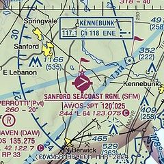
| Sectional chart |
|---|
|
| Airport distance calculator |
|---|
|
|
| Sunrise and sunset |
|---|
|
Times for 29-Nov-2025
| | Local
(UTC-5) | | Zulu
(UTC) |
|---|
| Morning civil twilight | | 06:22 | | 11:22 |
| Sunrise | | 06:54 | | 11:54 |
| Sunset | | 16:08 | | 21:08 |
| Evening civil twilight | | 16:40 | | 21:40 |
|
| Current date and time |
|---|
| Zulu (UTC) | 29-Nov-2025 09:48:42 |
|---|
| Local (UTC-5) | 29-Nov-2025 04:48:42 |
|---|
|
| METAR |
|---|
| KSFM | 290856Z AUTO 27009G19KT 10SM OVC046 M01/M08 A3005 RMK AO2 SLP183 T10061078 51032 FZRANO
|
|
| TAF |
|---|
KPSM
20nm S | 290520Z 2906/3006 27014G20KT P6SM SCT050 FM291500 28017G26KT P6SM FEW250 FM292100 30010KT P6SM FEW250 FM300100 VRB03KT P6SM FEW250
|
KPWM
23nm NE | 290520Z 2906/3006 27010G17KT P6SM SKC FM291300 28011G20KT P6SM FEW250 FM291500 28015G25KT P6SM FEW250 FM292100 30007KT P6SM FEW250 FM300100 VRB03KT P6SM FEW250
|
|
| NOTAMs |
|---|
NOTAMs are issued by the DoD/FAA and will open in a separate window not controlled by AirNav.
|
|


