FAA INFORMATION EFFECTIVE 22 JANUARY 2026
Location
| FAA Identifier: | SGJ |
| Lat/Long: | 29-57-33.3010N 081-20-23.0250W
29-57.555017N 081-20.383750W
29.9592503,-81.3397292
(estimated) |
| Elevation: | 9.8 ft. / 3.0 m (surveyed) |
| Variation: | 04W (1995) |
| From city: | 4 miles N of ST AUGUSTINE, FL |
| Time zone: | UTC -5 (UTC -4 during Daylight Saving Time) |
| Zip code: | 32095 |
Airport Operations
| Airport use: | Open to the public |
| Activation date: | 04/1940 |
| Control tower: | yes |
| ARTCC: | JACKSONVILLE CENTER |
| FSS: | GAINESVILLE FLIGHT SERVICE STATION |
| NOTAMs facility: | SGJ (NOTAM-D service available) |
| Attendance: | 0600-2200 |
| Wind indicator: | lighted |
| Segmented circle: | yes |
| Lights: | ACTVT MALSR RWY 31; HIRL RWY 13/31; MIRL RWY 06/24 & 2/20 - CTAF. PAPI RWY 06 & 31 AND VASI RWY 13 OPR CONSLY. |
| Beacon: | white-green (lighted land airport)
Operates sunset to sunrise. |
| Fire and rescue: | ARFF index A |
| Airline operations: | PPR 24 HRS FOR UNSKED ACR OPS WITH MORE THAN 30 PAX SEATS CALL AMGR 904-209-0090. |
| International operations: | INTL LRA. USER FEE CTC U.S.CUSTOMS ON ARPT
904-209-0099. |
Airport Communications
| CTAF: | 127.625 |
| UNICOM: | 122.95 |
| ATIS: | 119.625 |
| WX AWOS-3PT: | 119.625 (904-824-7084) |
| ST AUGUSTINE GROUND: | 121.175 251.125 [0700-2100] |
| ST AUGUSTINE TOWER: | 127.625 269.475 [0700-2100] |
| JACKSONVILLE APPROACH: | 120.75 |
| JACKSONVILLE DEPARTURE: | 120.75 |
Nearby radio navigation aids
| VOR radial/distance | | VOR name | | Freq | | Var |
|---|
| SGJ at field | | ST AUGUSTINE VOR/DME | | 109.40 | | 06W |
| CRGr162/24.4 | | CRAIG VORTAC | | 114.50 | | 03W |
| NDB name | | Hdg/Dist | | Freq | | Var | | ID |
|---|
| REYNOLDS | | 099/16.5 | | 338 | | 07W | | RYD | .-. -.-- -.. |
Airport Services
| Fuel available: | 100LL JET-A
A:SELF SVC FUEL AVBL 24 HRS WITH CREDIT CARD.
100LL:JET SINGLE POINT REFUELING AVBL. |
| Parking: | hangars and tiedowns |
| Airframe service: | MAJOR |
| Powerplant service: | MAJOR |
| Bottled oxygen: | HIGH/LOW |
| Bulk oxygen: | NONE |
Runway Information
Runway 13/31
| Dimensions: | 8001 x 150 ft. / 2439 x 46 m |
| Surface: | asphalt/grooved, in good condition |
| Weight bearing capacity: | | Single wheel: | 100.0 | | Double wheel: | 280.0 | | Double tandem: | 560.0 | | Dual double tandem: | 1120.0 |
|
| Runway edge lights: | high intensity |
| RUNWAY 13 | | RUNWAY 31 |
| Latitude: | 29-58.045175N | | 29-57.263318N |
| Longitude: | 081-21.042332W | | 081-19.820925W |
| Elevation: | 9.5 ft. | | 5.7 ft. |
| Traffic pattern: | left | | left |
| Runway heading: | 130 magnetic, 126 true | | 310 magnetic, 306 true |
| Displaced threshold: | 1056 ft. | | 806 ft. |
| Declared distances: | TORA:8001 TODA:8001 ASDA:7202 LDA:6144 | | TORA:8001 TODA:8001 ASDA:6730 LDA:5925 |
| Markings: | precision, in fair condition | | precision, in fair condition |
| Visual slope indicator: | 4-box VASI on left (3.00 degrees glide path) | | 4-light PAPI on left (3.00 degrees glide path) |
| Approach lights: | | | MALSR: 1,400 foot medium intensity approach lighting system with runway alignment indicator lights |
| Centerline lights: | yes | | yes |
| Touchdown point: | yes, no lights | | yes, no lights |
| Instrument approach: | | | ILS/DME |
| Obstructions: | 15 ft. road, 200 ft. from runway, 150 ft. right of centerline
ROAD 15 FT TALL 200 FT BFR AER OF RWY 13 150 RIGHT OF CNTRLN. | | none |
Runway 6/24
| Dimensions: | 2701 x 60 ft. / 823 x 18 m |
| Surface: | asphalt, in good condition |
| Weight bearing capacity: | | Single wheel: | 46.5 | | Double wheel: | 85.0 |
|
| Runway edge lights: | medium intensity |
| Operational restrictions: | RWY 06/24 NOT AVBL FOR PART 121/PART 380 OPS WITH SKED PAX CARRYING OPS MORE THAN 9 PAX SEATS AND NON-SKED PAX CARRYING OPS MORE THAN 30 PAX SEATS. |
| RUNWAY 6 | | RUNWAY 24 |
| Latitude: | 29-57.238898N | | 29-57.449053N |
| Longitude: | 081-20.476643W | | 081-20.025435W |
| Elevation: | 9.6 ft. | | 5.9 ft. |
| Traffic pattern: | left | | left |
| Runway heading: | 066 magnetic, 062 true | | 246 magnetic, 242 true |
| Declared distances: | TORA:2701 TODA:2701 ASDA:2701 LDA:2701 | | TORA:2701 TODA:2701 ASDA:2701 LDA:2701 |
| Markings: | basic, in good condition | | basic, in good condition |
| Visual slope indicator: | 2-light PAPI on left (3.25 degrees glide path) | | |
| Touchdown point: | yes, no lights | | yes, no lights |
| Obstructions: | 53 ft. trees, 1055 ft. from runway, 145 ft. right of centerline, 16:1 slope to clear | | none |
Runway 2/20
| Dimensions: | 2609 x 75 ft. / 795 x 23 m |
| Surface: | asphalt, in good condition |
| Weight bearing capacity: | | Single wheel: | 100.0 | | Double wheel: | 203.5 |
|
| Runway edge lights: | medium intensity |
| Operational restrictions: | RWY 02/20 NOT AVBL FOR PART 121/PART 380 OPS WITH SKED PAX CARRYING OPS MORE THAN 9 PAX SEATS AND NON-SKED PAX CARRYING OPS MORE THAN 30 PAX SEATS. |
| RUNWAY 2 | | RUNWAY 20 |
| Latitude: | 29-57.268190N | | 29-57.669928N |
| Longitude: | 081-20.463107W | | 081-20.285725W |
| Elevation: | 9.1 ft. | | 5.5 ft. |
| Traffic pattern: | left | | left |
| Runway heading: | 025 magnetic, 021 true | | 205 magnetic, 201 true |
| Declared distances: | TORA:2610 TODA:2610 ASDA:2610 LDA:2610 | | TORA:2610 TODA:2610 ASDA:2610 LDA:2610 |
| Markings: | basic, in good condition | | basic, in good condition |
| Touchdown point: | yes, no lights | | yes, no lights |
| Obstructions: | 76 ft. trees, 1345 ft. from runway, 75 ft. left of centerline, 15:1 slope to clear | | none |
Runway 17W/35W
| Dimensions: | 12000 x 1000 ft. / 3658 x 305 m |
| Surface: | water |
| Operational restrictions: | RWY 17W/35W NOT AVBL FOR PART 121/PART 380 OPS WITH SKED PAX CARRYING OPS MORE THAN 9 PAX SEATS AND NON-SKED PAX CARRYING OPS MORE THAN 30 PAX SEATS. |
| RUNWAY 17W | | RUNWAY 35W |
| Traffic pattern: | left | | left |
Runway 18W/36W
| Dimensions: | 12000 x 500 ft. / 3658 x 152 m |
| Surface: | water |
| Operational restrictions: | RWY 18W/36W NOT AVBL FOR PART 121/PART 380 OPS WITH SKED PAX CARRYING OPS MORE THAN 9 PAX SEATS AND NON-SKED PAX CARRYING OPS MORE THAN 30 PAX SEATS. |
| RUNWAY 18W | | RUNWAY 36W |
| Traffic pattern: | left | | left |
Runway 12W/30W
| Dimensions: | 5000 x 1000 ft. / 1524 x 305 m |
| Surface: | water |
| Operational restrictions: | RWY 12W/30W NOT AVBL FOR PART 121/PART 380 OPS WITH SKED PAX CARRYING OPS MORE THAN 9 PAX SEATS AND NON-SKED PAX CARRYING OPS MORE THAN 30 PAX SEATS. |
| RUNWAY 12W | | RUNWAY 30W |
| Traffic pattern: | left | | left |
Airport Ownership and Management from official FAA records
| Ownership: | Publicly-owned |
| Owner: | ST AUGUSTINE ARPT AUTH
4796 US 1 NORTH
ST AUGUSTINE, FL 32095
Phone 904-209-0090 |
| Manager: | COURTNEY PITTMAN
4796 US 1 NORTH
ST AUGUSTINE, FL 32095
Phone 904-209-0090 |
Additional Remarks
| A39-06/24 | PCR VALUE: 30/F/A/X/T |
| A39-13/31 | PCR VALUE: 790/F/A/X/T |
| A39-02/20 | PCR VALUE: 30/F/A/X/T |
| - | AEROBATIC ACT E SIDE OF RWY 13/31 CTC TWR FOR TFC & GNV RADIO FOR TIMES. |
| - | FICON NOT MNTD 2100 - 0700 LCL. |
| - | FOR CD IF UNA TO CTC ON FSS FREQ, CTC JACKSONVILLE APCH AT 904-741-0284. |
Instrument Procedures
NOTE: All procedures below are presented as PDF files. If you need a reader for these files, you should download the free Adobe Reader.NOT FOR NAVIGATION. Please procure official charts for flight.
FAA instrument procedures published for use from 22 January 2026 at 0901Z to 19 February 2026 at 0900z.
STARs - Standard Terminal Arrivals |
|---|
| HOTAR ONE (RNAV) | |
download (226KB) |
IAPs - Instrument Approach Procedures |
|---|
| ILS OR LOC RWY 31 | |
download (277KB) |
| RNAV (GPS) RWY 13 | |
download (275KB) |
| RNAV (GPS) RWY 31 | |
download (238KB) |
| NOTE: Special Alternate Minimums apply | |
download (146KB) |
| NOTE: Special Take-Off Minimums/Departure Procedures apply | |
download (409KB) |
Other nearby airports with instrument procedures:
KNIP - Jacksonville Naval Air Station (Towers Field) (24 nm NW)
KCRG - Jacksonville Executive Airport at Craig (24 nm N)
28J - Palatka Municipal Airport/Lt. Kay Larkin Field (26 nm SW)
KNRB - Mayport Naval Station (Adm David L. McDonald Field) (26 nm N)
KFIN - Flagler Executive Airport (30 nm S)
|
|

Road maps at:
MapQuest
Bing
Google
| Aerial photo |
|---|
WARNING: Photo may not be current or correct
 Photo by Jim Russell
Russell Aerial Photography Inc
Photo taken 07-Mar-2019
looking west-southwest.
Do you have a better or more recent aerial photo of St Augustine Airport that you would like to share? If so, please send us your photo.
|
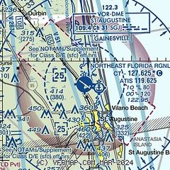
| Sectional chart |
|---|
|
 Download PDF
of official airport diagram from the FAA
| Airport distance calculator |
|---|
|
|
| Sunrise and sunset |
|---|
|
Times for 02-Feb-2026
| | Local
(UTC-5) | | Zulu
(UTC) |
|---|
| Morning civil twilight | | 06:51 | | 11:51 |
| Sunrise | | 07:16 | | 12:16 |
| Sunset | | 18:02 | | 23:02 |
| Evening civil twilight | | 18:27 | | 23:27 |
|
| Current date and time |
|---|
| Zulu (UTC) | 02-Feb-2026 12:18:36 |
|---|
| Local (UTC-5) | 02-Feb-2026 07:18:36 |
|---|
|
| METAR |
|---|
| KSGJ | 021156Z 30006KT 10SM CLR M02/M08 A3037 RMK AO2 SLP284 T10171083 11011 21022 51017 $
|
|
| TAF |
|---|
| KSGJ | 021120Z 0212/0312 29006KT P6SM SKC FM021500 31010G15KT P6SM SKC FM022300 26003KT P6SM SKC
|
|
| NOTAMs |
|---|
NOTAMs are issued by the DoD/FAA and will open in a separate window not controlled by AirNav.
|
|


