FAA INFORMATION EFFECTIVE 14 MAY 2026
Location
| FAA Identifier: | SNL |
| Lat/Long: | 35-21-26.3000N 096-56-34.2000W
35-21.438333N 096-56.570000W
35.3573056,-96.9428333
(estimated) |
| Elevation: | 1073.1 ft. / 327.1 m (surveyed) |
| Variation: | 06E (2000) |
| From city: | 2 miles NW of SHAWNEE, OK |
| Time zone: | UTC -5 (UTC -6 during Standard Time) |
| Zip code: | 74804 |
Airport Operations
| Airport use: | Open to the public |
| Activation date: | 10/1944 |
| Control tower: | no |
| ARTCC: | FORT WORTH CENTER |
| FSS: | MC ALESTER FLIGHT SERVICE STATION |
| NOTAMs facility: | SNL (NOTAM-D service available) |
| Attendance: | MON-FRI 0800-1700
AFT HRS CALL OUT AVBL - AMGR. |
| Wind indicator: | lighted |
| Segmented circle: | no |
| Lights: | MIRL RWY 17/35 PRESET LOW INTST; TO INCR INTST & ACTVT MALSR RWY 17 - CTAF. |
| Beacon: | white-green (lighted land airport)
Operates sunset to sunrise. |
Airport Communications
| CTAF/UNICOM: | 122.7 |
| WX AWOS-3PT: | 118.275 (405-214-1916) |
| OKE CITY APPROACH: | 120.45 |
| OKE CITY DEPARTURE: | 120.45 |
| WX AWOS-3 at SRE (14 nm E): | 118.625 (405-382-0111) |
Nearby radio navigation aids
| VOR radial/distance | | VOR name | | Freq | | Var |
|---|
| IRWr083/32.6 | | WILL ROGERS VORTAC | | 114.10 | | 07E |
| PWAr099/36.0 | | WILEY POST VOR/DME | | 113.40 | | 08E |
Airport Services
| Fuel available: | 100LL JET-A+
100LL:FUEL AVBL 24 HRS WITH CREDIT CARD. |
| Parking: | hangars and tiedowns |
| Airframe service: | MAJOR |
| Powerplant service: | MAJOR |
| Bottled oxygen: | NONE |
| Bulk oxygen: | NONE |
Runway Information
Runway 17/35
| Dimensions: | 5997 x 100 ft. / 1828 x 30 m |
| Surface: | asphalt, in good condition |
| Weight bearing capacity: | | Single wheel: | 30.0 | | Double wheel: | 40.0 | | Double tandem: | 60.0 |
|
| Runway edge lights: | medium intensity |
| RUNWAY 17 | | RUNWAY 35 |
| Latitude: | 35-21.932925N | | 35-20.944420N |
| Longitude: | 096-56.570597W | | 096-56.569513W |
| Elevation: | 1069.1 ft. | | 1067.7 ft. |
| Traffic pattern: | right | | left |
| Runway heading: | 174 magnetic, 180 true | | 354 magnetic, 360 true |
| Displaced threshold: | no | | 404 ft. |
| Markings: | precision, in good condition | | precision, in good condition |
| Visual slope indicator: | 4-light PAPI on left (3.00 degrees glide path) | | 4-light PAPI on left (3.00 degrees glide path) |
| Approach lights: | MALSR: 1,400 foot medium intensity approach lighting system with runway alignment indicator lights | | |
| Runway end identifier lights: | yes | | yes |
| Touchdown point: | yes, no lights | | yes, no lights |
| Instrument approach: | ILS/DME | | |
| Obstructions: | 22 ft. pline, 1275 ft. from runway, 300 ft. left of centerline, 48:1 slope to clear
TREE CREATES 48:1 APCH CLC SLP TO DISP THLD. | | 37 ft. trees, 1382 ft. from runway, 31:1 slope to clear |
Airport Ownership and Management from official FAA records
| Ownership: | Publicly-owned |
| Owner: | CITY OF SHAWNEE
16 W 9TH ST
SHAWNEE, OK 74801-1448
Phone 405-878-1601 |
| Manager: | BONNIE WILSON
2202 AIRPORT DR.
SHAWNEE, OK 74804
Phone 405-878-1633 |
Additional Remarks
| - | FOR CD CTC OKE APCH AT 405-681-5683. |
| - | PILOTS CONDUCTING EFVS OPS; BE AWARE LED ALS IN USE RWY 17. |
Instrument Procedures
NOTE: All procedures below are presented as PDF files. If you need a reader for these files, you should download the free Adobe Reader.NOT FOR NAVIGATION. Please procure official charts for flight.
FAA instrument procedures published for use from 14 May 2026 at 0901Z to 11 June 2026 at 0900Z.
STARs - Standard Terminal Arrivals |
|---|
| GULLI THREE | |
2 pages:
[1] [2] (336KB) |
IAPs - Instrument Approach Procedures |
|---|
| ILS OR LOC RWY 17 | |
download (235KB) |
| RNAV (GPS) RWY 17 | |
download (245KB) |
| RNAV (GPS) RWY 35 | |
download (243KB) |
| NOTE: Special Alternate Minimums apply | |
download (108KB) |
| NOTE: Special Take-Off Minimums/Departure Procedures apply | |
download (131KB) |
Other nearby airports with instrument procedures:
O47 - Prague Municipal Airport (13 nm NE)
KSRE - Seminole Municipal Airport (14 nm E)
KTIK - Tinker Air Force Base (22 nm W)
KCQB - Chandler Regional Airport (23 nm N)
KHMY - Muldrow Army Heliport (24 nm SW)
|
|

Road maps at:
MapQuest
Bing
Google
| Aerial photo |
|---|
WARNING: Photo may not be current or correct
 Photo by David Heon
Photo taken 06-Sep-2014
looking southeast.
Photo by David Heon
Photo taken 06-Sep-2014
looking southeast.
Do you have a better or more recent aerial photo of Shawnee Regional Airport that you would like to share? If so, please send us your photo.
|
| Sectional chart |
|---|
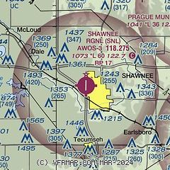
|
| Airport distance calculator |
|---|
|
|
| Sunrise and sunset |
|---|
|
Times for 10-Jun-2026
| | Local
(UTC-5) | | Zulu
(UTC) |
|---|
| Morning civil twilight | | 05:44 | | 10:44 |
| Sunrise | | 06:13 | | 11:13 |
| Sunset | | 20:41 | | 01:41 |
| Evening civil twilight | | 21:11 | | 02:11 |
|
| Current date and time |
|---|
| Zulu (UTC) | 10-Jun-2026 15:00:52 |
|---|
| Local (UTC-5) | 10-Jun-2026 10:00:52 |
|---|
|
| METAR |
|---|
| KSNL | 101435Z AUTO 21017G24KT 10SM CLR 29/19 A2989 RMK AO2 T02880194 TSNO
|
KSRE
14nm E | 101435Z AUTO 21008G15KT 180V240 10SM CLR 27/21 A2989 RMK AO2
|
|
| TAF |
|---|
KTIK
21nm W | 100100Z 1001/1107 18012KT 9999 SCT050 QNH2983INS BECMG 1012/1013 21015G25KT 9999 FEW045 QNH2972INS TX35/1022Z TN25/1012Z
|
KOUN
26nm W | 101120Z 1012/1112 18015KT P6SM FEW250 FM101400 19018G27KT P6SM FEW050 FM110400 18015G22KT P6SM SKC WS010/21050KT
|
|
| NOTAMs |
|---|
NOTAMs are issued by the DoD/FAA and will open in a separate window not controlled by AirNav.
|
|


