FAA INFORMATION EFFECTIVE 22 JANUARY 2026
Location
| FAA Identifier: | STC |
| Lat/Long: | 45-32-46.4000N 094-03-33.8000W
45-32.773333N 094-03.563333W
45.5462222,-94.0593889
(estimated) |
| Elevation: | 1030.5 ft. / 314 m (estimated) |
| Variation: | 03E (1995) |
| From city: | 4 miles E of ST CLOUD, MN |
| Time zone: | UTC -6 (UTC -5 during Daylight Saving Time) |
| Zip code: | 56304 |
Airport Operations
| Airport use: | Open to the public |
| Activation date: | 08/1970 |
| Control tower: | yes |
| ARTCC: | MINNEAPOLIS CENTER |
| FSS: | PRINCETON FLIGHT SERVICE STATION |
| NOTAMs facility: | STC (NOTAM-D service available) |
| Attendance: | 0500-2330 |
| Wind indicator: | lighted |
| Segmented circle: | yes |
| Lights: | ACTVT MALSR RWY 13 & 31 - CTAF. PAPI 13 & 31; HIRL RWY 13/31; MIRL RWY 05/23 PRESET ON LOW INTST, TO INCR INTST & ACTVT - CTAF. |
| Beacon: | white-green (lighted land airport)
Operates sunset to sunrise. |
| Fire and rescue: | ARFF index B |
| Airline operations: | 24 HRS PPR FOR UNSKED ACR OPNS WITH MORE THAN 30 PSGR SEATS CALL AMGR 320-255-7292. |
Airport Communications
| CTAF: | 118.25 |
| ATIS: | 119.375 |
| WX ASOS: | 125.075 (320-200-1187) |
| ST CLOUD GROUND: | 123.75 [0700-2300] |
| ST CLOUD TOWER: | 118.25 [0700-2300] |
| WX AWOS-3 at MGG (19 nm S): | 128.325 (320-963-3300) |
| WX AWOS-3 at PNM (19 nm E): | 119.025 (763-389-0615) |
- APCH/DEP SVC PRVDD BY MINNEAPOLIS ARTCC ON FREQS 121.05/235.775 (PRINCETON RCAG).
- COMMUNICATIONS PRVDD BY PRINCETON RADIO ON FREQ 122.5 (ST CLOUD RCO).
Nearby radio navigation aids
| VOR radial/distance | | VOR name | | Freq | | Var |
|---|
| STC at field | | ST CLOUD VOR/DME | | 112.10 | | 03E |
| GEPr304/37.6 | | GOPHER VORTAC | | 117.30 | | 06E |
| NDB name | | Hdg/Dist | | Freq | | Var | | ID |
|---|
| HUSSK | | 314/5.6 | | 342 | | 03E | | ST | ... - |
| RIPLEY | | 157/34.1 | | 404 | | 03E | | XCR | -..- -.-. .-. |
Airport Services
| Fuel available: | 100LL JET-A |
| Parking: | hangars and tiedowns |
| Airframe service: | MAJOR |
| Powerplant service: | MAJOR |
| Bottled oxygen: | NONE |
| Bulk oxygen: | HIGH |
Runway Information
Runway 13/31
| Dimensions: | 7500 x 150 ft. / 2286 x 46 m |
| Surface: | concrete/grooved, in good condition |
| Weight bearing capacity: | | Single wheel: | 75.0 | | Double wheel: | 175.0 | | Double tandem: | 280.0 |
|
| Runway edge lights: | high intensity |
| Operational restrictions: | RWY 13/31 200 FT BLAST PAD EACH END. |
| RUNWAY 13 | | RUNWAY 31 |
| Latitude: | 45-33.236297N | | 45-32.348625N |
| Longitude: | 094-04.160190W | | 094-02.940148W |
| Elevation: | 1030.5 ft. | | 1015.9 ft. |
| Traffic pattern: | left | | left |
| Runway heading: | 133 magnetic, 136 true | | 313 magnetic, 316 true |
| Displaced threshold: | no | | 500 ft. |
| Declared distances: | TORA:7500 TODA:7500 ASDA:7000 LDA:7000 | | TORA:7500 TODA:7500 ASDA:7500 LDA:7000 |
| Markings: | precision, in fair condition | | precision, in fair condition |
| Visual slope indicator: | 4-light PAPI on right (3.00 degrees glide path) | | 4-light PAPI on left (3.00 degrees glide path) |
| Approach lights: | MALSR: 1,400 foot medium intensity approach lighting system with runway alignment indicator lights | | MALSR: 1,400 foot medium intensity approach lighting system with runway alignment indicator lights |
| Runway end identifier lights: | no | | |
| Touchdown point: | yes, no lights | | yes, no lights |
| Instrument approach: | ILS | | ILS |
Runway 5/23
| Dimensions: | 3000 x 75 ft. / 914 x 23 m |
| Surface: | asphalt, in good condition |
| Weight bearing capacity: | | Single wheel: | 50.0 | | Double wheel: | 75.0 |
|
| Runway edge lights: | medium intensity |
| Operational restrictions: | RWY 05/23 NOT AVBL FOR PART 121/PART 380 OPS WITH SKED PAX CARRYING OPS MORE THAN 9 PAX SEATS AND NON-SKED PAX CARRYING OPS MORE THAN 30 PAX SEATS. |
| RUNWAY 5 | | RUNWAY 23 |
| Latitude: | 45-32.600160N | | 45-32.852173N |
| Longitude: | 094-03.899160W | | 094-03.295228W |
| Elevation: | 1021.1 ft. | | 1022.0 ft. |
| Traffic pattern: | left | | left |
| Runway heading: | 056 magnetic, 059 true | | 236 magnetic, 239 true |
| Declared distances: | TORA:3000 TODA:3000 ASDA:3000 LDA:3000 | | TORA:3000 TODA:3000 ASDA:3000 LDA:3000 |
| Markings: | basic, in good condition | | basic, in good condition |
| Visual slope indicator: | 4-light PAPI on right (3.00 degrees glide path) | | 4-light PAPI on left (3.00 degrees glide path) |
| Touchdown point: | yes, no lights | | yes, no lights |
Airport Ownership and Management from official FAA records
| Ownership: | Publicly-owned |
| Owner: | ST CLOUD RGNL ARPT AUTH
1550 45TH AVE SE STE 1
SAINT CLOUD, MN 56304-9634
Phone 320-255-7292 |
| Manager: | BILL P TOWLE
1550 45TH AVE SE STE 1
SAINT CLOUD, MN 56304-9634
Phone 320-255-7292
WILLIAM.TOWLE@CI.STCLOUD.MN.US. |
Additional Remarks
| A39-05/23 | PCR VALUE: 28/F/A/X/T |
| A39-13/31 | PCR VALUE: 380/R/A/W/T |
| - | RY 31 CALM WIND RY. |
| - | DEER, MIGRATORY WATERFOWL, AND OTHER WILDLIFE ON & INVOF ARPT. |
| - | FLIGHT TRAINING ON & INVOF ARPT. |
| - | CROP DUSTING OPERATIONS ON AND IN VICINITY OF AIRPORT DURING SUMMER MONTHS. |
| - | HELIPAD NOT VISIBLE FROM ATCT AND APPROACH SURFACES. |
| - | LINE OF SIGHT VISIBILITY IS RESTRICTED FROM THE 13 & 23 APPROACH AND RUNWAY 13 & 5 APPROACH |
| - | FOR CD WHEN ATCT IS CLSD CTC FSS VIA RCO, IF UNA CTC MINNEAPOLIS ARTCC AT 651-463-5588. |
Instrument Procedures
NOTE: All procedures below are presented as PDF files. If you need a reader for these files, you should download the free Adobe Reader.NOT FOR NAVIGATION. Please procure official charts for flight.
FAA instrument procedures published for use from 22 January 2026 at 0901Z to 19 February 2026 at 0900z.
IAPs - Instrument Approach Procedures |
|---|
| ILS OR LOC RWY 13 | |
download (295KB) |
| ILS OR LOC RWY 31 | |
download (304KB) |
| RNAV (GPS) RWY 05 | |
download (216KB) |
| RNAV (GPS) RWY 13 | |
download (275KB) |
| RNAV (GPS) RWY 23 | |
download (231KB) |
| RNAV (GPS) RWY 31 | |
download (294KB) |
| VOR RWY 31 | |
download (190KB) |
| NOTE: Special Alternate Minimums apply | |
download (175KB) |
| NOTE: Special Take-Off Minimums/Departure Procedures apply | |
download (156KB) |
Other nearby airports with instrument procedures:
KMGG - Maple Lake Municipal Airport-Bill Mavencamp Sr Field (19 nm S)
KPNM - Princeton Municipal Airport (19 nm E)
KCFE - Buffalo Municipal Airport (25 nm S)
KLXL - Little Falls/Morrison County Airport-Lindbergh Field (27 nm NW)
KPEX - Paynesville Municipal Airport (31 nm W)
|
|

Road maps at:
MapQuest
Bing
Google
| Aerial photo |
|---|
WARNING: Photo may not be current or correct
 Photo taken 26-Aug-2010
from a cessna 172R at 5500 ft MSL looking Southwest.
Photo taken 26-Aug-2010
from a cessna 172R at 5500 ft MSL looking Southwest.
Do you have a better or more recent aerial photo of St Cloud Regional Airport that you would like to share? If so, please send us your photo.
|
| Sectional chart |
|---|
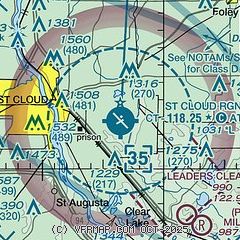
|
| Airport distance calculator |
|---|
|
|
| Sunrise and sunset |
|---|
|
Times for 01-Feb-2026
| | Local
(UTC-6) | | Zulu
(UTC) |
|---|
| Morning civil twilight | | 07:07 | | 13:07 |
| Sunrise | | 07:38 | | 13:38 |
| Sunset | | 17:21 | | 23:21 |
| Evening civil twilight | | 17:53 | | 23:53 |
|
| Current date and time |
|---|
| Zulu (UTC) | 01-Feb-2026 10:16:14 |
|---|
| Local (UTC-6) | 01-Feb-2026 04:16:14 |
|---|
|
| METAR |
|---|
| KSTC | 011000Z AUTO 18011KT 1SM -SN BR VV013 M08/M09 A2997 RMK AO2 P0001 T10831094
|
KMGG
19nm S | 010955Z AUTO 18011G16KT 3/4SM SN OVC005 M07/M09 A3002 RMK AO2 T10721095
|
KPNM
19nm E | 010955Z AUTO 19010G17KT 7SM -SN OVC025 M07/M09 A3000 RMK AO2 SNB0918 P0000 T10741093
|
|
| TAF |
|---|
| KSTC | 010533Z 0106/0206 18013G21KT P6SM OVC070 FM010830 18013G20KT 2SM -SN BR OVC018 FM011200 18008KT 3SM -SN BR OVC008 FM011600 28009KT 5SM -SHSN OVC014 FM012000 30012KT P6SM OVC020
|
|
| NOTAMs |
|---|
NOTAMs are issued by the DoD/FAA and will open in a separate window not controlled by AirNav.
|
|

