FAA INFORMATION EFFECTIVE 09 JULY 2026
Location
| FAA Identifier: | T74 |
| Lat/Long: | 30-34-21.5000N 097-26-35.5000W
30-34.358333N 097-26.591667W
30.5726389,-97.4431944
(estimated) |
| Elevation: | 600 ft. / 182.9 m (surveyed) |
| Variation: | 05E (2010) |
| From city: | 2 miles W of TAYLOR, TX |
| Time zone: | UTC -5 (UTC -6 during Standard Time) |
| Zip code: | 76574 |
Airport Operations
| Airport use: | Open to the public |
| Activation date: | 02/1946 |
| Control tower: | no |
| ARTCC: | HOUSTON CENTER |
| FSS: | SAN ANGELO FLIGHT SERVICE STATION |
| NOTAMs facility: | SJT (NOTAM-D service available) |
| Attendance: | MON-FRI 0800-1700 |
| Wind indicator: | lighted |
| Segmented circle: | yes |
| Lights: | MIRLS RWY 17/35 PRESET LOW SS-SR. TO ACTVT & INCR INTST - CTAF. |
| Beacon: | white-green (lighted land airport)
Operates sunset to sunrise. |
Airport Communications
| CTAF/UNICOM: | 122.8 |
| WX AWOS-3PT: | 119.75 (512-352-4995) |
| AUSTIN APPROACH: | 127.225 |
| AUSTIN DEPARTURE: | 127.225 |
| AEROZ DP: | 127.225 |
| BNDIA DP: | 127.225 |
| ELOEL DP: | 127.225 |
| GABOO STAR: | 127.225 |
| ILEXY DP: | 127.225 |
| MUCKY DP: | 127.225 |
| POTRR STAR: | 127.225 |
| SAYBR DP: | 127.225 |
| SZAGI STAR: | 118.15 ;SFC-7000 FT 119.0 ;8,000-12,000 FT |
| WX AWOS-3 at EDC (12 nm SW): | 118.825 (512-616-2967) |
| WX AWOS-3PT at GTU (14 nm NW): | PHONE 512-869-3430 |
Nearby radio navigation aids
| VOR radial/distance | | VOR name | | Freq | | Var |
|---|
| CWKr015/12.5 | | CENTEX VORTAC | | 112.80 | | 06E |
| GRKr138/33.6 | | GRAY VOR/DME | | 111.80 | | 07E |
Airport Services
| Fuel available: | 100LL JET-A+
A+:100 LL & JET A SELF SERVE ONLY. |
| Parking: | tiedowns |
| Airframe service: | MAJOR
HELI SVCS ALSO AVBL. |
| Powerplant service: | MAJOR |
| Bottled oxygen: | NONE |
| Bulk oxygen: | NONE |
Runway Information
Runway 17/35
| Dimensions: | 4000 x 75 ft. / 1219 x 23 m |
| Surface: | asphalt, in fair condition |
| Weight bearing capacity: | |
| Runway edge lights: | medium intensity |
| RUNWAY 17 | | RUNWAY 35 |
| Latitude: | 30-34.687477N | | 30-34.027922N |
| Longitude: | 097-26.600923W | | 097-26.583075W |
| Elevation: | 600.0 ft. | | 547.9 ft. |
| Traffic pattern: | right | | left |
| Runway heading: | 174 magnetic, 179 true | | 354 magnetic, 359 true |
| Displaced threshold: | no | | 249 ft. |
| Markings: | nonprecision, in fair condition | | nonprecision, in fair condition |
| Visual slope indicator: | 2-light PAPI on left (3.00 degrees glide path) | | 2-light PAPI on left (3.00 degrees glide path) |
| Runway end identifier lights: | | | no |
| Touchdown point: | yes, no lights | | yes, no lights |
| Obstructions: | 30 ft. trees, 1030 ft. from runway, 160 ft. left of centerline, 27:1 slope to clear | | 55 ft. trees, 835 ft. from runway, 215 ft. left and right of centerline, 11:1 slope to clear
APCH RATIO 25:1 TO DSPLCD THR OVR 80 FT TREES 2000 FT DSTC. |
Airport Ownership and Management from official FAA records
| Ownership: | Publicly-owned |
| Owner: | CITY OF TAYLOR
400 PORTER STREET
TAYLOR, TX 76574
Phone 512-352-3675 |
| Manager: | STACEY BATCH
303 AIRPORT RD., #101
TAYLOR, TX 76574
Phone 512-352-5747 |
Additional Remarks
| - | FOR CD CTC AUSTIN APCH AT 512-369-7865. |
| - | 200 FT. AGL TWR, 1000 FT EAST OF RWY CENTERLINE, APX MID POINT OF RWY. |
| - | INTSV HEL ACTVTY ON AND INVOF ARPT. |
Instrument Procedures
NOTE: All procedures below are presented as PDF files. If you need a reader for these files, you should download the free Adobe Reader.NOT FOR NAVIGATION. Please procure official charts for flight.
FAA instrument procedures published for use from 09 July 2026 at 0901Z to 06 August 2026 at 0900Z.
STARs - Standard Terminal Arrivals |
|---|
| BLEWE FIVE **NEW** | |
download (157KB) |
| GABOO ONE (RNAV) **NEW** | |
download (127KB) |
| POTRR TWO (RNAV) **NEW** | |
download (166KB) |
| SZAGI THREE (RNAV) **NEW** | |
download (196KB) |
IAPs - Instrument Approach Procedures |
|---|
| RNAV (GPS) RWY 17 | |
download (204KB) |
| VOR RWY 17 | |
download (178KB) |
| NOTE: Special Alternate Minimums apply | |
download (120KB) |
Departure Procedures |
|---|
| AEROZ TWO (RNAV) | |
download (145KB) |
| BNDIA THREE (RNAV) | |
download (133KB) |
| ELOEL THREE (RNAV) | |
download (156KB) |
| ILEXY FOUR (RNAV) | |
download (173KB) |
| MUCKY THREE (RNAV) | |
download (131KB) |
| SAYBR THREE (RNAV) | |
download (141KB) |
| NOTE: Special Take-Off Minimums/Departure Procedures apply | |
download (504KB) |
Other nearby airports with instrument procedures:
KEDC - Austin Executive Airport (12 nm SW)
KGTU - Georgetown Executive Airport (14 nm NW)
KAUS - Austin-Bergstrom International Airport (26 nm SW)
KRYW - Lago Vista TX/Rusty Allen Airport (28 nm W)
3R9 - Lakeway Airpark (31 nm SW)
|
|

Road maps at:
MapQuest
Bing
Google
| Aerial photo |
|---|
WARNING: Photo may not be current or correct
 Photo By Steve Basile Austin TX
Photo taken 05-Jun-2018
looking east.
Photo By Steve Basile Austin TX
Photo taken 05-Jun-2018
looking east.
Do you have a better or more recent aerial photo of Taylor Municipal Airport that you would like to share? If so, please send us your photo.
|
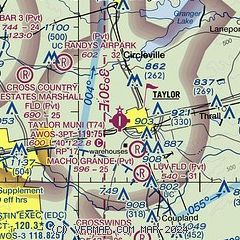
| Sectional chart |
|---|
|
| Airport distance calculator |
|---|
|
|
| Sunrise and sunset |
|---|
|
Times for 27-Jul-2026
| | Local
(UTC-5) | | Zulu
(UTC) |
|---|
| Morning civil twilight | | 06:19 | | 11:19 |
| Sunrise | | 06:46 | | 11:46 |
| Sunset | | 20:27 | | 01:27 |
| Evening civil twilight | | 20:53 | | 01:53 |
|
| Current date and time |
|---|
| Zulu (UTC) | 27-Jul-2026 18:20:20 |
|---|
| Local (UTC-5) | 27-Jul-2026 13:20:20 |
|---|
|
| METAR |
|---|
| KT74 | 271715Z AUTO 20006KT 10SM CLR 34/21 A3003 RMK AO2
|
KEDC
12nm SW | 271715Z AUTO VRB04KT 10SM CLR 33/21 A2999 RMK AO2 T03300213 $
|
KGTU
13nm NW | 271655Z 18009G17KT 10SM CLR 32/21 A3001 RMK AO2 SLP151 T03220206
|
|
| TAF |
|---|
KAUS
22nm SW | 271732Z 2718/2824 18011G19KT P6SM FEW060 FM280000 17011KT P6SM SKC FM280700 19005KT P6SM SCT040 FM281500 20011KT P6SM SCT040
|
|
| NOTAMs |
|---|
NOTAMs are issued by the DoD/FAA and will open in a separate window not controlled by AirNav.
|
|

