FAA INFORMATION EFFECTIVE 16 APRIL 2026
Location
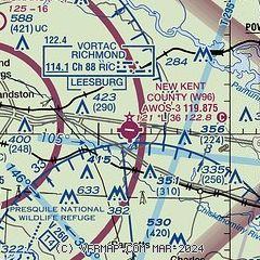
| FAA Identifier: | W96 |
| Lat/Long: | 37-30-12.3460N 077-07-35.6100W
37-30.205767N 077-07.593500W
37.5034294,-77.1265583
(estimated) |
| Elevation: | 120.7 ft. / 36.8 m (surveyed) |
| Variation: | 10W (2005) |
| From city: | 8 miles W of QUINTON, VA |
| Time zone: | UTC -4 (UTC -5 during Standard Time) |
| Zip code: | 23141 |
Airport Operations
| Airport use: | Open to the public |
| Activation date: | 06/1938 |
| Control tower: | no |
| ARTCC: | WASHINGTON CENTER |
| FSS: | LEESBURG FLIGHT SERVICE STATION |
| NOTAMs facility: | DCA (NOTAM-D service available) |
| Attendance: | 0900-1700 |
| Pattern altitude: | 920.7 ft. MSL |
| Wind indicator: | lighted |
| Segmented circle: | yes |
| Lights: | ACTVT REIL RWY 11 & 29; MIRL RWY 11/29 - CTAF. |
| Beacon: | white-green (lighted land airport)
ROTG BCN NOT VISIBLE WHEN APPROACHING FM THE NORTH. Operates sunset to sunrise. |
Airport Communications
| CTAF/UNICOM: | 122.8 |
| WX AWOS-3: | 119.875 (804-932-8863) |
| POTOMAC APPROACH: | 126.4 |
| POTOMAC DEPARTURE: | 126.4 |
| WX ASOS at RIC (9 nm W): | PHONE 804-223-6573 |
| WX AWOS-3 at FYJ (17 nm E): | 132.825 (804-785-2307) |
| WX ASOS at OFP (19 nm NW): | 119.025 (804-752-2902) |
| WX AWOS-3PT at FCI (20 nm W): | 128.625 (804-271-8426) |
Nearby radio navigation aids
| VOR radial/distance | | VOR name | | Freq | | Var |
|---|
| RICr099/9.2 | | RICHMOND VORTAC | | 114.10 | | 09W |
| HPWr003/10.5 | | HOPEWELL VORTAC | | 114.35 | | 06W |
| HCMr286/20.0 | | HARCUM VORTAC | | 108.80 | | 07W |
| FAKr099/33.4 | | FLAT ROCK VORTAC | | 113.30 | | 06W |
| NDB name | | Hdg/Dist | | Freq | | Var | | ID |
|---|
| WAKEFIELD | | 000/31.8 | | 274 | | 11W | | AKQ | .- -.- --.- |
Airport Services
| Fuel available: | 100LL
100LL:FUEL AVBL 24 HRS, CREDIT CARD REQUIRED WHEN UNATTENDED. |
| Parking: | hangars and tiedowns |
| Airframe service: | MINOR |
| Powerplant service: | MINOR |
| Bottled oxygen: | NONE |
| Bulk oxygen: | NONE |
Runway Information
Runway 11/29
| Dimensions: | 3602 x 75 ft. / 1098 x 23 m |
| Surface: | asphalt, in good condition |
| Weight bearing capacity: | |
| Runway edge lights: | medium intensity |
| RUNWAY 11 | | RUNWAY 29 |
| Latitude: | 37-30.237100N | | 37-30.174408N |
| Longitude: | 077-07.963902W | | 077-07.223118W |
| Elevation: | 120.7 ft. | | 107.5 ft. |
| Traffic pattern: | left | | left |
| Runway heading: | 106 magnetic, 096 true | | 286 magnetic, 276 true |
| Markings: | nonprecision, in fair condition | | nonprecision, in fair condition |
| Visual slope indicator: | 2-light PAPI on right (4.00 degrees glide path) | | 2-light PAPI on left (4.00 degrees glide path) |
| Runway end identifier lights: | yes | | yes |
| Touchdown point: | yes, no lights | | yes, no lights |
| Obstructions: | 5 ft. road, 258 ft. from runway, 9 ft. both sides of centerline, 11:1 slope to clear
RWY 11 - ROADWAY +15 FT 260 FT FM RWY END. | | 20 ft. trees, 438 ft. from runway, 165 ft. right of centerline, 11:1 slope to clear
13 FT BRUSH, 101 FT RIGHT OF CTRLN ON APCH AT THLD. |
Airport Ownership and Management from official FAA records
| Ownership: | Publicly-owned |
| Owner: | COUNTY OF NEW KENT
P. O. BOX 150, 12007 COURT HOUSE CIRCLE
NEW KENT, VA 23124
Phone 804-966-9683 |
| Manager: | RUSS PEADEN
6901 TERMINAL RD
QUINTON, VA 23141-2427
Phone 804-932-3984 |
Additional Remarks
| - | DEER ON & INVOF ARPT. |
| - | FOR CD CTC POTOMAC APCH AT 866-640-4124. |
Instrument Procedures
NOTE: All procedures below are presented as PDF files. If you need a reader for these files, you should download the free Adobe Reader.NOT FOR NAVIGATION. Please procure official charts for flight.
FAA instrument procedures published for use from 16 April 2026 at 0901Z to 14 May 2026 at 0900Z.
IAPs - Instrument Approach Procedures |
|---|
| RNAV (GPS) RWY 11 | |
download (238KB) |
| RNAV (GPS) RWY 29 | |
download (263KB) |
| VOR-A | |
download (225KB) |
| NOTE: Special Alternate Minimums apply | |
download (169KB) |
| NOTE: Special Alternate Minimums apply | |
download (169KB) |
| NOTE: Special Take-Off Minimums/Departure Procedures apply | |
download (155KB) |
Other nearby airports with instrument procedures:
KRIC - Richmond International Airport (9 nm W)
KFYJ - Middle Peninsula Regional Airport (17 nm E)
KOFP - Hanover County Municipal Airport (19 nm NW)
KFCI - Richmond Executive-Chesterfield County Airport (20 nm W)
KXSA - Tappahannock/Essex County Airport (24 nm NE)
|
|

Road maps at:
MapQuest
Bing
Google
| Aerial photo |
|---|
WARNING: Photo may not be current or correct

Do you have a better or more recent aerial photo of New Kent County Airport that you would like to share? If so, please send us your photo.
|
| Sectional chart |
|---|
|
| Airport distance calculator |
|---|
|
|
| Sunrise and sunset |
|---|
|
Times for 18-Apr-2026
| | Local
(UTC-4) | | Zulu
(UTC) |
|---|
| Morning civil twilight | | 06:03 | | 10:03 |
| Sunrise | | 06:31 | | 10:31 |
| Sunset | | 19:45 | | 23:45 |
| Evening civil twilight | | 20:12 | | 00:12 |
|
| Current date and time |
|---|
| Zulu (UTC) | 19-Apr-2026 03:26:23 |
|---|
| Local (UTC-4) | 18-Apr-2026 23:26:23 |
|---|
|
| METAR |
|---|
| KW96 | 190315Z AUTO 00000KT 10SM CLR 21/15 A2980 RMK AO1 T02070151
|
KRIC
9nm W | 190254Z 16007KT 10SM SCT250 22/15 A2980 RMK AO2 SLP095 T02220150 58009 $
|
KFYJ
17nm E | 190315Z AUTO 15007KT 10SM CLR 21/15 A2982 RMK AO1 T02110150
|
KOFP
19nm NW | 190254Z AUTO VRB03KT 10SM CLR 21/15 A2982 RMK AO2 SLP095 T02060150 58009
|
KFCI
20nm W | 190256Z AUTO 18003KT 10SM CLR 21/14 A2981 RMK AO2 SLP104 T02060144 58006 $
|
|
| TAF |
|---|
KRIC
9nm W | 182304Z 1823/1918 15009KT P6SM BKN250 FM190800 22011KT P6SM BKN100 FM191100 30010G16KT P6SM VCSH BKN035 FM191400 35014G22KT 6SM -SHRA SCT025 OVC035
|
|
| NOTAMs |
|---|
NOTAMs are issued by the DoD/FAA and will open in a separate window not controlled by AirNav.
|
|


