FAA INFORMATION EFFECTIVE 07 AUGUST 2025
Location
| FAA Identifier: | AGS |
| Lat/Long: | 33-22-11.8000N 081-57-52.2000W
33-22.196667N 081-57.870000W
33.3699444,-81.9645000
(estimated) |
| Elevation: | 145.7 ft. / 44.4 m (surveyed) |
| Variation: | 04W (1990) |
| From city: | 6 miles S of AUGUSTA, GA |
| Time zone: | UTC -4 (UTC -5 during Standard Time) |
| Zip code: | 30906 |
Airport Operations
| Airport use: | Open to the public |
| Activation date: | 10/1943 |
| Control tower: | yes |
| ARTCC: | ATLANTA CENTER |
| FSS: | MACON FLIGHT SERVICE STATION |
| NOTAMs facility: | AGS (NOTAM-D service available) |
| Attendance: | CONTINUOUS |
| Wind indicator: | yes |
| Segmented circle: | yes |
| Lights: | PAPI RWYS 08, 17, 26 & 35, OPER CONSLY. REIL RWY 08 & 26; MIRL RWY 08/26; HIRL RWY 17/35 OPER CONSLY WHEN ATCT CLSD. ACTVT MALSR RWY 17 & 35 - CTAF. |
| Beacon: | white-green (lighted land airport)
Operates sunset to sunrise. |
| Fire and rescue: | ARFF index B |
| Airline operations: | ARFF INDEX C AVBL UPON REQUEST. |
Airport Communications
| CTAF: | 118.7 |
| UNICOM: | 122.95 |
| ATIS: | 132.75 |
| WX ASOS: | PHONE 706-250-6089 |
| AUGUSTA GROUND: | 121.9 348.6 [0645-2300] |
| AUGUSTA TOWER: | 118.7 239.3 [0645-2300] |
| AUGUSTA APPROACH: | 119.15 ;350-169 126.8 ;170-349 270.3 ;170-349 284.625 ;350-169 [0645-2300] |
| AUGUSTA DEPARTURE: | 119.15 ;350-169 126.8 ;170-349 270.3 ;170-349 284.625 ;350-169 [0645-2300] |
| CLEARANCE DELIVERY: | 118.65 |
| ARMY OPS: | 149.7 49.9FM |
| EMERG: | 121.5 243.0 |
| IC: | 126.8 ;170-349 270.3 ;170-349 |
| MEDEVAC: | 32.5FM |
| STUGE STAR: | 119.15 284.625 |
| STWRT STAR: | 119.15 284.625 |
| TRSA: | 119.15 ;350-169 126.8 ;170-349 270.3 ;170-349 284.625 ;350-169 |
| WX ASOS at DNL (7 nm NW): | 135.275 (706-481-8629) |
- APCH/DEP SVC PRVDD BY ATLANTA ARTCC ON FREQS 128.1/322.325 (AUGUSTA RCAG) WHEN APCH CTL CLSD.
Nearby radio navigation aids
| VOR radial/distance | | VOR name | | Freq | | Var |
|---|
| IRQr158/22.5 | | COLLIERS VORTAC | | 113.90 | | 04W |
| ALDr303/(40.0) | | ALLENDALE VOR | | 116.70 | | 01W |
| NDB name | | Hdg/Dist | | Freq | | Var | | ID |
|---|
| BUSHE | | 354/5.1 | | 233 | | 04W | | AG | .- --. |
| EMORY | | 168/5.8 | | 385 | | 04W | | EMR | . -- .-. |
| AIKEN | | 226/22.2 | | 347 | | 06W | | AIK | .- .. -.- |
Airport Services
| Fuel available: | 100LL JET-A |
| Parking: | hangars and tiedowns |
| Airframe service: | MAJOR |
| Powerplant service: | MAJOR |
| Bottled oxygen: | HIGH/LOW |
| Bulk oxygen: | HIGH/LOW |
Runway Information
Runway 17/35
| Dimensions: | 8001 x 150 ft. / 2439 x 46 m |
| Surface: | concrete/grooved, in good condition |
| Weight bearing capacity: | | PCN 73 /R/B/W/T | | Single wheel: | 155.0 | | Double wheel: | 160.0, 2S-175. | | Double tandem: | 450.0 | | Dual double tandem: | 975.0, 2T-585K (B-C-17), 2D/2D2-975K (747), 840K (C-5) 2D/2D2-975K (747). |
|
| Runway edge lights: | high intensity |
| RUNWAY 17 | | RUNWAY 35 |
| Latitude: | 33-22.943375N | | 33-21.651907N |
| Longitude: | 081-58.250302W | | 081-57.929105W |
| Elevation: | 144.8 ft. | | 133.7 ft. |
| Traffic pattern: | left | | left |
| Runway heading: | 172 magnetic, 168 true | | 352 magnetic, 348 true |
| Markings: | precision, in good condition | | precision, in good condition |
| Visual slope indicator: | 4-light PAPI on left (3.00 degrees glide path) | | 4-light PAPI on left (3.00 degrees glide path) |
| RVR equipment: | touchdown, rollout | | touchdown, rollout |
| Approach lights: | MALSR: 1,400 foot medium intensity approach lighting system with runway alignment indicator lights | | MALSR: 1,400 foot medium intensity approach lighting system with runway alignment indicator lights |
| Touchdown point: | yes, no lights | | yes, no lights |
| Instrument approach: | ILS | | ILS |
| Obstructions: | 90 ft. tree, 2450 ft. from runway, 800 ft. left of centerline, 38:1 slope to clear | | 42 ft. trees, 1500 ft. from runway, 600 ft. left of centerline, 21:1 slope to clear
PER SURVEY DEC 2004 RWY 17-35. |
Runway 8/26
| Dimensions: | 6002 x 75 ft. / 1829 x 23 m |
| Surface: | asphalt/grooved, in good condition |
| Weight bearing capacity: | | PCN 40 /F/B/W/T | | Single wheel: | 52.0 | | Double wheel: | 71.0 | | Double tandem: | 126.0 |
|
| Runway edge lights: | medium intensity |
| Operational restrictions: | RWY 08/26 NOT AVBL FOR SKED ACR OPNS WITH MORE THAN 9 PSGR SEATS OR UNSKED ACR AT LEAST 31 PSGR SEATS. |
| RUNWAY 8 | | RUNWAY 26 |
| Latitude: | 33-21.962198N | | 33-22.164453N |
| Longitude: | 081-58.154152W | | 081-56.999665W |
| Elevation: | 133.7 ft. | | 137.5 ft. |
| Traffic pattern: | left | | left |
| Runway heading: | 082 magnetic, 078 true | | 262 magnetic, 258 true |
| Markings: | nonprecision, in good condition | | nonprecision, in good condition |
| Visual slope indicator: | 4-light PAPI on left (3.00 degrees glide path) | | 4-light PAPI on left (3.00 degrees glide path) |
| Runway end identifier lights: | yes | | yes |
| Touchdown point: | yes, no lights | | yes, no lights |
| Obstructions: | 52 ft. trees, 1250 ft. from runway, 125 ft. right of centerline, 20:1 slope to clear | | 65 ft. trees, 1250 ft. from runway, 200 ft. left of centerline, 16:1 slope to clear |
Airport Ownership and Management from official FAA records
| Ownership: | Publicly-owned |
| Owner: | CITY OF AUGUSTA
AVIATION DEPARTMENT, 1501 AVIATION WAY
AUGUSTA, GA 30906
Phone 706-798-2656 |
| Manager: | HERBERT JUDON
1501 AVIATION WAY
AUGUSTA, GA 30906
Phone 706-798-3236 |
Additional Remarks
| - | BIRDS ON & INVOF ARPT. HVY BIRD ACT INVOF ARPT NOV-MAR. |
| - | CAUTION: TAXI-LANE RAMP ENTRANCE/EXIT POINT INTO STANDARD AERO STORM WATER DITCH ON NORTH SIDE. |
| - | CAUTION: WILDLIFE HAZARD COYOTE. |
| - | FOR CD IF UNA TO CTC ON FSS FREQ, CTC AUGUSTA APCH AT 706-771-1777, WHEN APCH CLSD CTC ATLANTA ARTCC AT 770-210-7692. |
| - | TWY ALL EAST OF RWY 17/35 CLSD TO AIR CARRIER ACFT. |
Instrument Procedures
NOTE: All procedures below are presented as PDF files. If you need a reader for these files, you should download the free Adobe Reader.NOT FOR NAVIGATION. Please procure official charts for flight.
FAA instrument procedures published for use from 07 August 2025 at 0901Z to 04 September 2025 at 0900z.
STARs - Standard Terminal Arrivals |
|---|
| STUGE THREE | |
2 pages:
[1] [2] (249KB) |
| STWRT THREE | |
download (196KB) |
IAPs - Instrument Approach Procedures |
|---|
| ILS OR LOC RWY 17 **CHANGED** | |
download (267KB) |
| ILS OR LOC RWY 35 **CHANGED** | |
download (292KB) |
| RNAV (GPS) RWY 17 **CHANGED** | |
download (256KB) |
| RNAV (GPS) RWY 26 **CHANGED** | |
download (270KB) |
| RNAV (GPS) RWY 35 **CHANGED** | |
download (259KB) |
| RNAV (GPS) Y RWY 08 **CHANGED** | |
download (259KB) |
| RNAV (GPS) Z RWY 08 **CHANGED** | |
download (273KB) |
| NOTE: Special Alternate Minimums apply | |
download (153KB) |
Departure Procedures |
|---|
| CHATT SIX (RNAV) | |
download (206KB) |
| DOVER FIVE (RNAV) | |
download (185KB) |
| JUNPR SIX (RNAV) | |
download (188KB) |
| KAOLN SIX (RNAV) | |
download (178KB) |
| RDBUD FOUR (RNAV) | |
download (181KB) |
| SAMMI FOUR (RNAV) | |
download (167KB) |
| NOTE: Special Take-Off Minimums/Departure Procedures apply | |
download (479KB) |
Other nearby airports with instrument procedures:
KDNL - Daniel Field Airport (7 nm NW)
KBXG - Burke County Airport (20 nm S)
KAIK - Aiken Regional Airport (22 nm NE)
2J5 - Millen Airport (29 nm S)
KHQU - Thomson/McDuffie County Airport (29 nm W)
|
|

Road maps at:
MapQuest
Bing
Google
| Aerial photo |
|---|
WARNING: Photo may not be current or correct
 Photo courtesy of AirNav, LLC
Photo taken 25-Jun-2011
looking south.
Photo courtesy of AirNav, LLC
Photo taken 25-Jun-2011
looking south.
Do you have a better or more recent aerial photo of Augusta Regional Airport at Bush Field that you would like to share? If so, please send us your photo.
|
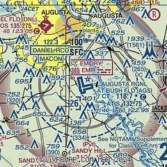
| Sectional chart |
|---|
|
 Download PDF
of official airport diagram from the FAA
| Airport distance calculator |
|---|
|
|
| Sunrise and sunset |
|---|
|
Times for 02-Sep-2025
| | Local
(UTC-4) | | Zulu
(UTC) |
|---|
| Morning civil twilight | | 06:38 | | 10:38 |
| Sunrise | | 07:04 | | 11:04 |
| Sunset | | 19:51 | | 23:51 |
| Evening civil twilight | | 20:17 | | 00:17 |
|
| Current date and time |
|---|
| Zulu (UTC) | 02-Sep-2025 16:30:00 |
|---|
| Local (UTC-4) | 02-Sep-2025 12:30:00 |
|---|
|
| METAR |
|---|
| KAGS | 021553Z 08009G15KT 10SM CLR 27/15 A3007 RMK AO2 SLP181 T02670150 $
|
KDNL
7nm NW | 021553Z AUTO 10007KT 060V120 10SM SCT041 26/14 A3009 RMK AO2 SLP186 T02560139
|
|
| TAF |
|---|
| KAGS | 021139Z 0212/0312 35003KT P6SM SKC FM021500 05008KT P6SM FEW060 SCT250 FM030000 VRB02KT P6SM FEW200
|
KDNL
7nm NW | 021139Z 0212/0312 02006KT P6SM SKC FM021500 03008KT P6SM FEW060 SCT250 FM030000 06004KT P6SM FEW200
|
|
| NOTAMs |
|---|
NOTAMs are issued by the DoD/FAA and will open in a separate window not controlled by AirNav.
|
|


