FAA INFORMATION EFFECTIVE 19 FEBRUARY 2026
Location
| FAA Identifier: | C66 |
| Lat/Long: | 40-55-46.9360N 090-37-51.9860W
40-55.782267N 090-37.866433W
40.9297044,-90.6311072
(estimated) |
| Elevation: | 753 ft. / 229.5 m (surveyed) |
| Variation: | 03E (1980) |
| From city: | 2 miles N of MONMOUTH, IL |
| Time zone: | UTC -6 (UTC -5 during Daylight Saving Time) |
| Zip code: | 61462 |
Airport Operations
| Airport use: | Open to the public |
| Activation date: | 04/1940 |
| Control tower: | no |
| ARTCC: | CHICAGO CENTER |
| FSS: | KANKAKEE FLIGHT SERVICE STATION |
| NOTAMs facility: | IKK (NOTAM-D service available) |
| Attendance: | TUE-SUN 0800-1630 |
| Wind indicator: | lighted |
| Segmented circle: | yes |
| Lights: | ACTVT PAPI RWY 03 & 21; MIRL RWY 03/21 PRESET LOW INTST, TO INCR INTST & ACTVT - CTAF. |
| Beacon: | white-green (lighted land airport)
Operates sunset to sunrise. |
Airport Communications
| CTAF/UNICOM: | 122.8 |
| QUAD CITY APPROACH: | 133.275 [0530-2230] |
| QUAD CITY DEPARTURE: | 133.275 [0530-2230] |
| CLEARANCE DELIVERY: | 120.7 |
| WX AWOS-3 at GBG (9 nm E): | 118.975 (309-343-3711) |
- APCH/DEP SVC PRVDD BY CHICAGO ARTCC ON FREQS 135.6/370.95 (BURLINGTON RCAG) WHEN MOLINE APCH CTL CLSD.
Nearby radio navigation aids
| VOR radial/distance | | VOR name | | Freq | | Var |
|---|
| BRLr042/18.2 | | BURLINGTON VOR/DME | | 115.55 | | 05E |
| MZVr174/23.5 | | MOLINE VOR/DME | | 114.40 | | 05E |
| NDB name | | Hdg/Dist | | Freq | | Var | | ID |
|---|
| MACOMB | | 352/24.9 | | 251 | | 01E | | JZY | .--- --.. -.-- |
Airport Services
| Fuel available: | 100LL MOGAS
100LL:24 HR SELF SERVE FUEL |
| Parking: | hangars and tiedowns |
| Airframe service: | NONE |
| Powerplant service: | NONE |
| Bottled oxygen: | NONE |
| Bulk oxygen: | NONE |
Runway Information
Runway 3/21
| Dimensions: | 2899 x 60 ft. / 884 x 18 m |
| Surface: | asphalt, in good condition |
| Weight bearing capacity: | |
| Runway edge lights: | medium intensity |
| RUNWAY 3 | | RUNWAY 21 |
| Latitude: | 40-55.563917N | | 40-56.002067N |
| Longitude: | 090-37.991517W | | 090-37.741583W |
| Elevation: | 753.0 ft. | | 748.0 ft. |
| Traffic pattern: | left | | left |
| Runway heading: | 020 magnetic, 023 true | | 200 magnetic, 203 true |
| Markings: | basic, in good condition | | basic, in fair condition |
| Visual slope indicator: | 2-light PAPI on left (3.50 degrees glide path) | | 2-light PAPI on left (3.00 degrees glide path) |
| Runway end identifier lights: | no | | no |
| Touchdown point: | yes, no lights | | yes, no lights |
| Obstructions: | 34 ft. tree, 681 ft. from runway, 147 ft. right of centerline, 14:1 slope to clear | | 52 ft. tree, 789 ft. from runway, 180 ft. right of centerline, 11:1 slope to clear |
Airport Ownership and Management from official FAA records
| Ownership: | Publicly-owned |
| Owner: | CITY OF MONMOUTH
100 E. BROADWAY
MONMOUTH, IL 61462-1764
Phone 309-734-2141 |
| Manager: | ANNETTE ST. LEDGER
100 E. BROADWAY
MONMOUTH, IL 61462-1764
Phone 309-734-2141
EMAIL ADDRESS: ANNETTE.STLEDGER@CITYOFMONMOUTHIL.GOV |
Additional Remarks
| A30A-03 | SEASONAL CROPS IN PART 77 SFC; 200 FT FROM RWY END 61 FT L. |
| - | FOR CD CTC CHICAGO ARTCC AT 630-906-8921. |
Instrument Procedures
NOTE: All procedures below are presented as PDF files. If you need a reader for these files, you should download the free Adobe Reader.NOT FOR NAVIGATION. Please procure official charts for flight.
FAA instrument procedures published for use from 19 February 2026 at 0901Z to 19 March 2026 at 0900Z.
IAPs - Instrument Approach Procedures |
|---|
| RNAV (GPS)-A **CHANGED** | |
download (165KB) |
| NOTE: Special Take-Off Minimums/Departure Procedures apply | |
download (372KB) |
Other nearby airports with instrument procedures:
KGBG - Harrel W Timmons Galesburg Regional Airport (9 nm E)
KBRL - Southeast Iowa Regional Airport (24 nm W)
KMQB - Macomb Municipal Airport (25 nm S)
KMLI - Quad Cities International Airport (32 nm N)
KCTK - Ingersoll Airport (33 nm SE)
|
|

Road maps at:
MapQuest
Bing
Google
| Aerial photo |
|---|
WARNING: Photo may not be current or correct

Do you have a better or more recent aerial photo of Monmouth Municipal Airport that you would like to share? If so, please send us your photo.
|
| Sectional chart |
|---|
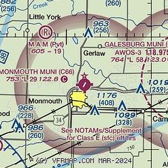
|
| Airport distance calculator |
|---|
|
|
| Sunrise and sunset |
|---|
|
Times for 13-Mar-2026
| | Local
(UTC-5) | | Zulu
(UTC) |
|---|
| Morning civil twilight | | 06:51 | | 11:51 |
| Sunrise | | 07:19 | | 12:19 |
| Sunset | | 19:06 | | 00:06 |
| Evening civil twilight | | 19:33 | | 00:33 |
|
| Current date and time |
|---|
| Zulu (UTC) | 13-Mar-2026 13:51:15 |
|---|
| Local (UTC-5) | 13-Mar-2026 08:51:15 |
|---|
|
| METAR |
|---|
KGBG
9nm E | 131335Z AUTO 28032G39KT 10SM SCT028 03/00 A2974 RMK AO2 T00260000
|
|
| TAF |
|---|
KBRL
25nm SW | 131136Z 1312/1412 28025G35KT P6SM SKC FM131300 28020G30KT P6SM SKC FM131800 29015G25KT P6SM SCT150 FM140000 31009KT P6SM SCT150 FM140700 05005KT P6SM BKN070
|
|
| NOTAMs |
|---|
NOTAMs are issued by the DoD/FAA and will open in a separate window not controlled by AirNav.
|
|

