FAA INFORMATION EFFECTIVE 17 APRIL 2025
Location
| FAA Identifier: | I18 |
| Lat/Long: | 38-55-47.2000N 081-49-10.1000W
38-55.786667N 081-49.168333W
38.9297778,-81.8194722
(estimated) |
| Elevation: | 758.2 ft. / 231.1 m (surveyed) |
| Variation: | 07W (2000) |
| From city: | 6 miles SW of RAVENSWOOD, WV |
| Time zone: | UTC -4 (UTC -5 during Standard Time) |
| Zip code: | 25262 |
Airport Operations
| Airport use: | Open to the public |
| Control tower: | no |
| ARTCC: | INDIANAPOLIS CENTER |
| FSS: | ELKINS FLIGHT SERVICE STATION [703-724-4288] |
| NOTAMs facility: | EKN (NOTAM-D service available) |
| Attendance: | 0800-1600 |
| Wind indicator: | lighted |
| Segmented circle: | yes |
| Lights: | ACTVT REIL RWY 04 & 22, PAPI RWY 04 & 22; MIRL RWY 04/22 & WINDSOCK LGT - CTAF. |
| Beacon: | white-green (lighted land airport)
Operates sunset to sunrise. |
Airport Communications
| CTAF/UNICOM: | 122.8 |
| WX AWOS-2: | 121.3 (304-273-3424) |
| HUNTINGTON APPROACH: | 128.4 |
| HUNTINGTON DEPARTURE: | 128.4 |
| WX AWOS-3 at 3I2 (13 nm W): | 119.675 (304-675-4618) |
| WX AWOS-3PT at GAS (17 nm W): | 119.925 (740-446-2149) |
Nearby radio navigation aids
| VOR radial/distance | | VOR name | | Freq | | Var |
|---|
| HVQr359/34.9 | | CHARLESTON VOR/DME | | 117.40 | | 03W |
| JPUr217/37.0 | | PARKERSBURG VOR/DME | | 114.45 | | 03W |
| NDB name | | Hdg/Dist | | Freq | | Var | | ID |
|---|
| UNIVERSITY | | 150/24.3 | | 250 | | 06W | | UGS | ..- --. ... |
Airport Services
| Fuel available: | 100LL |
| Parking: | hangars and tiedowns |
| Airframe service: | MAJOR |
| Powerplant service: | MAJOR |
| Bottled oxygen: | NONE |
| Bulk oxygen: | NONE |
Runway Information
Runway 4/22
| Dimensions: | 4000 x 75 ft. / 1219 x 23 m |
| Surface: | asphalt, in excellent condition |
| Weight bearing capacity: | |
| Runway edge lights: | medium intensity |
| RUNWAY 4 | | RUNWAY 22 |
| Latitude: | 38-55.499507N | | 38-56.072532N |
| Longitude: | 081-49.377135W | | 081-48.960700W |
| Elevation: | 738.0 ft. | | 758.2 ft. |
| Traffic pattern: | left | | left |
| Runway heading: | 037 magnetic, 030 true | | 217 magnetic, 210 true |
| Markings: | nonprecision, in good condition | | nonprecision, in good condition |
| Visual slope indicator: | 2-light PAPI on left (3.00 degrees glide path) | | 2-light PAPI on left (4.00 degrees glide path)
VGSI AND DESCENT ANGLES NOT COINCIDENT. |
| Runway end identifier lights: | yes | | yes |
| Touchdown point: | yes, no lights | | yes, no lights |
| Obstructions: | 61 ft. trees, 1430 ft. from runway, 20:1 slope to clear | | 22 ft. trees, 220 ft. from runway, 245 ft. left of centerline, 1:1 slope to clear
16 FT TREES, 150-200 DSTC, 170-250 FT L. |
Airport Ownership and Management from official FAA records
| Ownership: | Publicly-owned |
| Owner: | JACKSON COUNTY CMSN
P. O. BOX 800
RIPLEY, WV 25271
Phone 304-373-2220 |
| Manager: | RALPH DENNIS
912 AIRPORT RD
MILLWOOD, WV 25262
Phone 304-273-8114
304-532-6781 MGR CELL. |
Additional Remarks
| - | DEER AND BIRDS ON & INVOF ARPT. |
| - | +482 FT STACK 1/2 MILE NW OF ARPT. |
| - | RWY SAFETY AREA HAS SFC VARIATIONS. |
| - | RWY 04/22, 50 FT DROP-OFF 200 FT FM THR - EACH END. |
| - | 15 FT TREES PARALLEL TO RWY 04, 75 FT L OF CNTRLN. |
| - | FOR CD CTC HUNTINGTON ATCT AT 304-453-2490. |
Instrument Procedures
NOTE: All procedures below are presented as PDF files. If you need a reader for these files, you should download the free Adobe Reader.NOT FOR NAVIGATION. Please procure official charts for flight.
FAA instrument procedures published for use from 17 April 2025 at 0901Z to 15 May 2025 at 0900z.
IAPs - Instrument Approach Procedures |
|---|
| RNAV (GPS) RWY 04 | |
download (210KB) |
| RNAV (GPS) RWY 22 | |
download (217KB) |
| NOTE: Special Take-Off Minimums/Departure Procedures apply | |
download (149KB) |
Other nearby airports with instrument procedures:
3I2 - Mason County Airport (13 nm W)
KGAS - Gallia-Meigs Regional Airport (17 nm W)
KUSW - Boggs Field Airport (23 nm E)
KUNI - Ohio University Airport (26 nm NW)
KPKB - Mid-Ohio Valley Regional Airport (31 nm NE)
|
|

Road maps at:
MapQuest
Bing
Google
| Aerial photo |
|---|
WARNING: Photo may not be current or correct

Do you have a better or more recent aerial photo of Jackson County Airport that you would like to share? If so, please send us your photo.
|
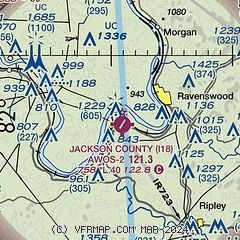
| Sectional chart |
|---|
|
| Airport distance calculator |
|---|
|
|
| Sunrise and sunset |
|---|
|
Times for 10-May-2025
| | Local
(UTC-4) | | Zulu
(UTC) |
|---|
| Morning civil twilight | | 05:51 | | 09:51 |
| Sunrise | | 06:20 | | 10:20 |
| Sunset | | 20:27 | | 00:27 |
| Evening civil twilight | | 20:57 | | 00:57 |
|
| Current date and time |
|---|
| Zulu (UTC) | 10-May-2025 15:24:30 |
|---|
| Local (UTC-4) | 10-May-2025 11:24:30 |
|---|
|
| METAR |
|---|
KUNI
26nm NW | 101455Z AUTO 00000KT 5SM HZ CLR 18/02 A3023 RMK AO2 T01810017 TSNO
|
|
| TAF |
|---|
KPKB
31nm NE | 101137Z 1012/1112 00000KT P6SM SKC FM101400 36004KT P6SM FEW250
|
KCRW
35nm S | 101137Z 1012/1112 00000KT P6SM FEW250 TEMPO 1012/1013 4SM BR FEW001 FM101400 03003KT P6SM SCT210
|
|
| NOTAMs |
|---|
NOTAMs are issued by the DoD/FAA and will open in a separate window not controlled by AirNav.
|
|


