FAA INFORMATION EFFECTIVE 14 MAY 2026
Location
| FAA Identifier: | 3I2 |
| Lat/Long: | 38-54-52.6850N 082-05-54.8840W
38-54.878083N 082-05.914733W
38.9146347,-82.0985789
(estimated) |
| Elevation: | 643.4 ft. / 196.1 m (surveyed) |
| Variation: | 07W (2000) |
| From city: | 4 miles NE of POINT PLEASANT, WV |
| Time zone: | UTC -4 (UTC -5 during Standard Time) |
| Zip code: | 25550 |
Airport Operations
| Airport use: | Open to the public |
| Control tower: | no |
| ARTCC: | INDIANAPOLIS CENTER |
| FSS: | ELKINS FLIGHT SERVICE STATION [703-724-4288] |
| NOTAMs facility: | EKN (NOTAM-D service available) |
| Attendance: | MON-FRI 1000-1400 |
| Wind indicator: | lighted |
| Segmented circle: | yes |
| Lights: | ACTVT REIL RWY 07 & 25; PAPI RWY 07 & 25; MIRL RWY 07/25 - CTAF. |
| Beacon: | white-green (lighted land airport)
Operates sunset to sunrise. |
Airport Communications
| CTAF/UNICOM: | 122.8 |
| WX AWOS-3: | 119.675 (304-675-4618) |
| HUNTINGTON APPROACH: | 128.4 |
| HUNTINGTON DEPARTURE: | 128.4 |
| WX AWOS-3PT at GAS (6 nm SW): | 119.925 (740-446-2149) |
| WX AWOS-2 at I18 (13 nm E): | 121.3 (304-273-3424) |
| WX AWOS-3 at UNI (19 nm N): | 128.325 (740-597-2687) |
Nearby radio navigation aids
| VOR radial/distance | | VOR name | | Freq | | Var |
|---|
| HVQr339/37.2 | | CHARLESTON VOR/DME | | 117.40 | | 03W |
| NDB name | | Hdg/Dist | | Freq | | Var | | ID |
|---|
| UNIVERSITY | | 182/20.6 | | 250 | | 06W | | UGS | ..- --. ... |
Airport Services
| Bottled oxygen: | NONE |
| Bulk oxygen: | NONE |
Runway Information
Runway 7/25
| Dimensions: | 4000 x 75 ft. / 1219 x 23 m |
| Surface: | asphalt, in fair condition |
| Weight bearing capacity: | |
| Runway edge lights: | medium intensity |
| RUNWAY 7 | | RUNWAY 25 |
| Latitude: | 38-54.738182N | | 38-55.017960N |
| Longitude: | 082-06.296492W | | 082-05.532967W |
| Elevation: | 639.0 ft. | | 625.4 ft. |
| Traffic pattern: | left | | left |
| Runway heading: | 072 magnetic, 065 true | | 252 magnetic, 245 true |
| Markings: | nonprecision, in fair condition | | nonprecision, in fair condition |
| Visual slope indicator: | 2-light PAPI on left (3.00 degrees glide path) | | 2-light PAPI on left (3.00 degrees glide path) |
| Runway end identifier lights: | yes | | yes |
| Touchdown point: | yes, no lights | | yes, no lights |
| Obstructions: | 20 ft. trees, 420 ft. from runway, 20 ft. right of centerline, 11:1 slope to clear
30 FT TREES, 0-199 DSTC, 75 FT R. | | 35 ft. trees, 300 ft. from runway, 140 ft. left and right of centerline, 2:1 slope to clear |
Airport Ownership and Management from official FAA records
| Ownership: | Publicly-owned |
| Owner: | MASON CO COMISSION
COURT HOUSE, 200 6TH ST,
POINT PLEASANT, WV 25550
Phone 304-675-1110 |
| Manager: | TRENT AND PAIGE ROUSH
1518 AIRPORT RD
POINT PLEASANT, WV 25550
Phone 304-674-5075 |
Additional Remarks
| - | DEER ON & INVOF ARPT. |
| - | COLD TEMPERATURE AIRPORT. ALTITUDE CORRECTION REQUIRED AT OR BELOW -16C. |
| - | FOR CD CTC HUNTINGTON ATCT AT 304-453-2490. |
| - | SEVERAL POWER PLANT STACKS IN VICINITY OF ARPT WEST & NORTH. |
| - | RWY 25, 35 FT DROP-OFF, 100 FT FM RWY END. |
| - | STEAM FROM COOLING TOWERS NW OCCASIONALLY OBSCURES OBSTN LGTS ON TOWER NORTH. |
| - | RWY 07 HAS 3 FT DITCH 80 FT L & R OF CNTRLN FIRST 1000 FT. |
| - | 6-8 FT BRUSH PARALLEL TO RWY 25, 95 FT FM CENTERLINE. |
Instrument Procedures
NOTE: All procedures below are presented as PDF files. If you need a reader for these files, you should download the free Adobe Reader.NOT FOR NAVIGATION. Please procure official charts for flight.
FAA instrument procedures published for use from 14 May 2026 at 0901Z to 11 June 2026 at 0900Z.
IAPs - Instrument Approach Procedures |
|---|
| RNAV (GPS) RWY 07 | |
download (213KB) |
| RNAV (GPS) RWY 25 | |
download (250KB) |
| NOTE: Special Alternate Minimums apply | |
download (26KB) |
| NOTE: Special Take-Off Minimums/Departure Procedures apply | |
download (210KB) |
Other nearby airports with instrument procedures:
KGAS - Gallia-Meigs Regional Airport (6 nm SW)
I18 - Jackson County Airport (13 nm E)
KUNI - Ohio University Airport (19 nm N)
KJRO - James A Rhodes Airport (23 nm W)
12V - Ona Airpark (29 nm S)
|
|

Road maps at:
MapQuest
Bing
Google
| Aerial photo |
|---|
WARNING: Photo may not be current or correct

Do you have a better or more recent aerial photo of Mason County Airport that you would like to share? If so, please send us your photo.
|
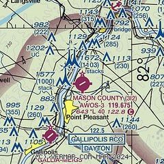
| Sectional chart |
|---|
|
| Airport distance calculator |
|---|
|
|
| Sunrise and sunset |
|---|
|
Times for 01-Jun-2026
| | Local
(UTC-4) | | Zulu
(UTC) |
|---|
| Morning civil twilight | | 05:34 | | 09:34 |
| Sunrise | | 06:06 | | 10:06 |
| Sunset | | 20:47 | | 00:47 |
| Evening civil twilight | | 21:18 | | 01:18 |
|
| Current date and time |
|---|
| Zulu (UTC) | 01-Jun-2026 06:47:07 |
|---|
| Local (UTC-4) | 01-Jun-2026 02:47:07 |
|---|
|
| METAR |
|---|
KUNI
19nm N | 010635Z AUTO 00000KT 10SM CLR 13/12 A2999 RMK AO2 T01260125
|
|
| TAF |
|---|
KHTS
39nm SW | 010520Z 0106/0206 00000KT P6SM FEW180 FM011500 01005KT P6SM SCT150
|
KCRW
40nm SE | 010520Z 0106/0206 00000KT P6SM FEW240 TEMPO 0108/0112 4SM BR SCT001 FM011400 01004KT P6SM BKN110
|
KPKB
41nm NE | 010520Z 0106/0206 00000KT P6SM FEW210 FM011400 02005KT P6SM SCT180
|
|
| NOTAMs |
|---|
NOTAMs are issued by the DoD/FAA and will open in a separate window not controlled by AirNav.
|
|

