FAA INFORMATION EFFECTIVE 27 NOVEMBER 2025
Location
| FAA Identifier: | I44 |
| Lat/Long: | 39-45-54.3800N 084-20-34.6600W
39-45.906333N 084-20.577667W
39.7651056,-84.3429611
(estimated) |
| Elevation: | 925 ft. / 282 m (estimated) |
| From city: | 7 miles W of DAYTON, OH |
| Time zone: | UTC -5 (UTC -4 during Daylight Saving Time) |
| Zip code: | 45427 |
Airport Operations
| Airport use: | Open to the public |
| Activation date: | 08/1971 |
| Control tower: | no |
| ARTCC: | INDIANAPOLIS CENTER |
| FSS: | DAYTON FLIGHT SERVICE STATION |
| NOTAMs facility: | DAY (NOTAM-D service available) |
| Attendance: | UNATNDD |
| Wind indicator: | yes |
| Segmented circle: | no |
Airport Communications
| CTAF/UNICOM: | 122.8 |
| COLUMBUS APPROACH: | 118.85 |
| COLUMBUS DEPARTURE: | 118.85 |
| WX ASOS at DAY (10 nm NE): | PHONE 937-419-1421 |
| WX ASOS at MGY (12 nm SE): | 118.375 (937-885-2171) |
| WX AWOS-3PT at MWO (14 nm S): | 120.025 (513-422-3505) |
| WX AWOS-3 at GDK (17 nm E): | 118.525 (937-372-4668) |
| WX AWOS-3PT at I68 (19 nm S): | 120.55 (513-934-5500) |
Nearby radio navigation aids
| VOR radial/distance | | VOR name | | Freq | | Var |
|---|
| DQNr172/15.3 | | DAYTON VOR/DME | | 114.50 | | 01W |
| MXQr313/32.1 | | MIDWEST VOR/DME | | 112.90 | | 04W |
| RODr209/34.3 | | ROSEWOOD VORTAC | | 117.50 | | 05W |
| NDB name | | Hdg/Dist | | Freq | | Var | | ID |
|---|
| BRUNY | | 190/4.9 | | 315 | | 06W | | AT | .- - |
| ONIDA | | 359/11.3 | | 223 | | 04W | | MW | -- .-- |
Airport Services
| Airframe service: | NONE |
| Powerplant service: | NONE |
| Bottled oxygen: | NONE |
| Bulk oxygen: | NONE |
Runway Information
Runway 4/22
| Dimensions: | 2900 x 52 ft. / 884 x 16 m |
| Surface: | asphalt, in poor condition
NMRS CRACKS IN PAVEMENT WITH 3 FT VEGETATION & EXTSV FOD. |
| Weight bearing capacity: | | Single wheel: | 5000 LBS PER AMGR. |
|
| RUNWAY 4 | | RUNWAY 22 |
| Latitude: | 39-45.731333N | | 39-46.081333N |
| Longitude: | 084-20.787667W | | 084-20.367667W |
| Elevation: | 925.0 ft. | | 925.0 ft. |
| Traffic pattern: | left | | left |
| Runway heading: | 043 true | | 223 true |
| Markings: | numbers only, in fair condition | | numbers only, in fair condition |
| Runway end identifier lights: | no | | no |
| Obstructions: | 77 ft. trees, 700 ft. from runway, 109 ft. right of centerline, 6:1 slope to clear | | 40 ft. trees, 201 ft. from runway, 90 ft. left of centerline, 1:1 slope to clear
+10-20 FT BRUSH/TREES, 25 FT DIST, 20-125 FT L; +10-25 FT BRUSH/TREES, 0 FT DIST, 20-125 FT R. |
Airport Ownership and Management from official FAA records
| Ownership: | Privately-owned |
| Owner: | S & S LAND & FARMS, LLC
1550 SOLDIERS HOME-WEST CARROLLTON
DAYTON, OH 45417-6146
Phone 937-263-2676 |
| Manager: | STEVE RAUCH
1550 SOLDIERS HOME-WEST CARROLLTON
DAYTON, OH 45417-6146
Phone 937-604-2619 |
Additional Remarks
| - | ULTRALIGHTS & PWRD PRCHTS ON & INVOF ARPT. |
| - | FOR CD CTC COLUMBUS APCH AT 614-338-8537. |
| - | MOWED PATH FM RWY 04 END TO HNGR AREA NOT SUITABLE FOR ACFT. |
| - | TWY FM MIDFIELD TO HNGR AREA IN POOR COND - EXTSV VEGETATION & FOD. |
| - | SEASONAL CROPS ALG ENTR LEN RWY 04/22, 10 FT FM RWY EDGE, BOTH SIDES. |
Instrument Procedures
There are no published instrument procedures at I44.
Some nearby airports with instrument procedures:
I73 - Moraine Air Park (7 nm SE)
3I7 - Dayton/Phillipsburg Airport (9 nm N)
KDAY - James M Cox Dayton International Airport (10 nm NE)
KMGY - Dayton/Wright Brothers Airport (12 nm SE)
KFFO - Wright-Patterson Air Force Base (14 nm E)
KMWO - Middletown Regional Airport/Hook Field (14 nm S)
KGDK - Greene County/Lewis A Jackson Regional Airport (17 nm E)
I68 - Warren County Airport/John Lane Field (19 nm S)
|
|

Road maps at:
MapQuest
Bing
Google
| Aerial photo |
|---|
WARNING: Photo may not be current or correct
 Photo taken 12-Oct-2014
looking southwest.
Photo taken 12-Oct-2014
looking southwest.
Do you have a better or more recent aerial photo of Dahio Trotwood Airport that you would like to share? If so, please send us your photo.
|
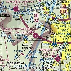
| Sectional chart |
|---|
|
| Airport distance calculator |
|---|
|
|
| Sunrise and sunset |
|---|
|
Times for 17-Dec-2025
| | Local
(UTC-5) | | Zulu
(UTC) |
|---|
| Morning civil twilight | | 07:23 | | 12:23 |
| Sunrise | | 07:54 | | 12:54 |
| Sunset | | 17:13 | | 22:13 |
| Evening civil twilight | | 17:44 | | 22:44 |
|
| Current date and time |
|---|
| Zulu (UTC) | 17-Dec-2025 08:02:48 |
|---|
| Local (UTC-5) | 17-Dec-2025 03:02:48 |
|---|
|
| METAR |
|---|
KDAY
10nm NE | 170756Z 21013KT 10SM BKN220 03/M07 A2993 RMK AO2 SLP143 T00281072
|
KMGY
11nm SE | 170753Z AUTO 22012G21KT 10SM CLR 05/M07 A2994 RMK AO2 SLP145 T00501072
|
KMWO
14nm S | 170755Z AUTO 21010KT 10SM CLR 04/M04 A2998 RMK AO2
|
KFFO
15nm E | 170755Z AUTO 22013KT 10SM CLR 04/M05 A2993 RMK AO2 SLP144 T00441054
|
KI68
19nm S | 170755Z AUTO 22008KT 10SM OVC042 06/M05 A2995 RMK AO2
|
|
| TAF |
|---|
KDAY
10nm NE | 170530Z 1706/1806 21012G18KT P6SM BKN045 WS020/22040KT FM171400 23010KT P6SM SCT035 BKN120 FM171800 25008KT P6SM BKN035 BKN200 FM180200 16008KT P6SM SCT040 BKN200
|
KFFO
15nm E | 170300Z 1703/1809 22009KT 9999 BKN025 BKN040 WS020/22040KT 620254 QNH2992INS TEMPO 1704/1711 22010G18KT BECMG 1712/1713 24014KT 9999 BKN020 BKN120 620204 QNH2996INS BECMG 1715/1716 25012KT 9999 SCT030 BKN120 BKN200 QNH3003INS BECMG 1719/1720 17009KT 9999 BKN025 BKN100 620252 QNH2996INS BECMG 1806/1807 18012KT 9999 BKN030 BKN060 620306 520103 QNH2991INS TX06/1720Z TN01/1711Z
|
|
| NOTAMs |
|---|
NOTAMs are issued by the DoD/FAA and will open in a separate window not controlled by AirNav.
|
|


