FAA INFORMATION EFFECTIVE 16 APRIL 2026
Location
| FAA Identifier: | ALN |
| Lat/Long: | 38-53-23.7000N 090-02-45.6000W
38-53.395000N 090-02.760000W
38.8899167,-90.0460000
(estimated) |
| Elevation: | 543.5 ft. / 165.7 m (surveyed) |
| Variation: | 01W (2010) |
| From city: | 4 miles E of central business district of the associated city |
| Time zone: | UTC -5 (UTC -6 during Standard Time) |
| Zip code: | 62010 |
Airport Operations
| Airport use: | Open to the public |
| Activation date: | 04/1940 |
| Control tower: | yes |
| ARTCC: | KANSAS CITY CENTER |
| FSS: | SAINT LOUIS FLIGHT SERVICE STATION |
| NOTAMs facility: | ALN (NOTAM-D service available) |
| Attendance: | 0700-2200
ATTENDANT AFT HR - CALL 618-259-3230 OR 258-1005. |
| Wind indicator: | lighted |
| Segmented circle: | no |
| Lights: | ACTVT MALSR RWY 29; REIL RWY 11 - CTAF. WHEN ATCT CLSD PAPI 11, 17, 35; HIRL RWY 11/29; MIRL RWY 17/35 PRESET ON LOW INTST, TO INCR INTST & ACTVT - CTAF. |
| Beacon: | white-green (lighted land airport)
Operates sunset to sunrise. |
| Fire and rescue: | ARFF index A |
Airport Communications
| CTAF: | 126.0 |
| UNICOM: | 122.95 |
| ATIS: | 128.0 |
| WX AWOS-3PT: | 128.0 (618-259-7231) |
| REGIONAL GROUND: | 120.2 [0700-2200] |
| REGIONAL TOWER: | 126.0 239.0 [0700-2200] |
| SAINT LOUIS APPROACH: | 124.2 |
| SAINT LOUIS DEPARTURE: | 124.2 |
| CLEARANCE DELIVERY: | 120.2 ;WHEN TWR CLSD |
| DELMA STAR: | 128.1 |
| FARMR STAR: | 119.15 |
| WX ASOS at STL (17 nm SW): | PHONE 314-238-8419 |
| WX ASOS at SET (18 nm W): | 118.075 (636-250-4590) |
| WX ASOS at CPS (20 nm S): | PHONE 618-332-0001 |
Nearby radio navigation aids
| VOR radial/distance | | VOR name | | Freq | | Var |
|---|
| TOYr323/10.8 | | TROY VORTAC | | 116.00 | | 04E |
| STLr084/20.5 | | ST LOUIS VORTAC | | 117.40 | | 01E |
Airport Services
| Fuel available: | 100LL JET-A |
| Parking: | hangars and tiedowns |
| Airframe service: | MAJOR |
| Powerplant service: | MAJOR |
| Bottled oxygen: | HIGH |
| Bulk oxygen: | HIGH |
Runway Information
Runway 11/29
| Dimensions: | 8099 x 150 ft. / 2469 x 46 m |
| Surface: | asphalt/grooved, in good condition |
| Weight bearing capacity: | | Single wheel: | 106.0 | | Double wheel: | 144.0 | | Double tandem: | 198.0 | | Dual double tandem: | 575.0 |
|
| Runway edge lights: | high intensity |
| Operational restrictions: | RWY 11/29 NOT AVBL FOR PART 121/PART 380 OPS WITH SKED PAX CARRYING OPS MORE THAN 9 PAX SEATS AND NON-SKED PAX CARRYING OPS MORE THAN 30 PAX SEATS. 90 DAY PPR FOR UNSKED ACR OPS GTR THAN 30 PAX SEATS - CALL AMGR. |
| RUNWAY 11 | | RUNWAY 29 |
| Latitude: | 38-53.714347N | | 38-53.185312N |
| Longitude: | 090-03.297748W | | 090-01.730558W |
| Elevation: | 537.8 ft. | | 526.4 ft. |
| Traffic pattern: | left | | left |
| Runway heading: | 114 magnetic, 113 true | | 294 magnetic, 293 true |
| Declared distances: | TORA:8099 TODA:8099 ASDA:8099 LDA:8099 | | TORA:8099 TODA:8099 ASDA:8099 LDA:8099 |
| Markings: | precision, in good condition | | precision, in good condition |
| Visual slope indicator: | 4-light PAPI on right (3.00 degrees glide path) | | |
| Approach lights: | | | MALSR: 1,400 foot medium intensity approach lighting system with runway alignment indicator lights |
| Runway end identifier lights: | yes | | no |
| Touchdown point: | yes, no lights | | yes, no lights |
| Instrument approach: | | | ILS/DME |
| Obstructions: | 35 ft. tree, 1275 ft. from runway, 475 ft. right of centerline, 30:1 slope to clear | | none |
Runway 17/35
| Dimensions: | 6500 x 100 ft. / 1981 x 30 m |
| Surface: | asphalt, in good condition |
| Weight bearing capacity: | | Single wheel: | 47.0 | | Double wheel: | 63.0 | | Double tandem: | 109.0 |
|
| Runway edge lights: | medium intensity |
| Operational restrictions: | RWY 17/35 NOT AVBL FOR PART 121/PART 380 OPS WITH SKED PAX CARRYING OPS MORE THAN 9 PAX SEATS AND NON-SKED PAX CARRYING OPS MORE THAN 30 PAX SEATS. 90 DAY PPR FOR UNSKED ACR OPS GTR THAN 30 PAX SEATS - CALL AMGR. |
| RUNWAY 17 | | RUNWAY 35 |
| Latitude: | 38-53.858408N | | 38-52.794913N |
| Longitude: | 090-03.143970W | | 090-02.985398W |
| Elevation: | 533.4 ft. | | 542.3 ft. |
| Traffic pattern: | left | | left |
| Runway heading: | 174 magnetic, 173 true | | 354 magnetic, 353 true |
| Markings: | nonprecision, in fair condition | | nonprecision, in fair condition |
| Visual slope indicator: | 4-light PAPI on left (3.00 degrees glide path) | | 4-light PAPI on left (3.00 degrees glide path) |
| Touchdown point: | yes, no lights | | yes, no lights |
| Obstructions: | 18 ft. tree, 896 ft. from runway, 139 ft. left of centerline, 38:1 slope to clear | | 32 ft. trees, 1379 ft. from runway, 72 ft. right of centerline, 36:1 slope to clear |
Airport Ownership and Management from official FAA records
| Ownership: | Publicly-owned |
| Owner: | ST. LOUIS REGIONAL
8 TERMINAL DR SUITE 1
EAST ALTON, IL 62024
Phone 618-259-2531 |
| Manager: | DANIEL ADAMS, AAE
8 TERMINAL DR, SUITE 1
EAST ALTON, IL 62024
Phone 618-259-2531 |
Additional Remarks
| A39-11/29 | PCR VALUE: 440/F/D/X/T |
| A39-17/35 | PCR VALUE: 180/F/D/X/T |
| - | RWY 11 & 17 APCH ENDS CLOSELY ALIGNED; VERIFY CORRECT COMPASS HDG PRIOR TO DEP. |
| - | INDEX B FFR EQUIP AVBL WITH 30-MIN PPR. |
| - | MIGRATORY BIRD ACTIVITY IN VICINITY OF ARPT SEPTEMBER THROUGH APRIL. |
| - | WILDLIFE ON AND IN VICINITY OF AIRPORT |
Instrument Procedures
NOTE: All procedures below are presented as PDF files. If you need a reader for these files, you should download the free Adobe Reader.NOT FOR NAVIGATION. Please procure official charts for flight.
FAA instrument procedures published for use from 16 April 2026 at 0901Z to 14 May 2026 at 0900Z.
STARs - Standard Terminal Arrivals |
|---|
| DELMA FOUR (RNAV) | |
download (267KB) |
| FARMR THREE (RNAV) | |
download (209KB) |
IAPs - Instrument Approach Procedures |
|---|
| ILS OR LOC RWY 29 | |
download (294KB) |
| RNAV (GPS) RWY 11 | |
download (226KB) |
| RNAV (GPS) RWY 17 | |
download (230KB) |
| RNAV (GPS) RWY 29 | |
download (255KB) |
| RNAV (GPS) RWY 35 | |
download (279KB) |
| VOR-A | |
download (252KB) |
| NOTE: Special Alternate Minimums apply | |
download (162KB) |
Departure Procedures |
|---|
| GATEWAY ONE | |
2 pages:
[1] [2] (395KB) |
| LINDBERGH NINE | |
download (228KB) |
| OZARK EIGHT | |
download (148KB) |
| PLESS FIVE | |
download (171KB) |
| NOTE: Special Take-Off Minimums/Departure Procedures apply | |
download (201KB) |
Other nearby airports with instrument procedures:
KSTL - St Louis Lambert International Airport (17 nm SW)
KSET - St Charles County Regional Airport/Smartt Field (18 nm W)
KCPS - St Louis Downtown Airport (20 nm S)
KBLV - Scott Air Force Base/MidAmerica Airport (23 nm SE)
1H0 - Creve Coeur Airport (24 nm SW)
|
|

Road maps at:
MapQuest
Bing
Google
| Aerial photo |
|---|
WARNING: Photo may not be current or correct
 Photo courtesy of Bob Srenco, Srenco Photography
Photo taken 17-May-2011
looking southeast.
Photo courtesy of Bob Srenco, Srenco Photography
Photo taken 17-May-2011
looking southeast.
Do you have a better or more recent aerial photo of St Louis Regional Airport that you would like to share? If so, please send us your photo.
|
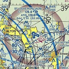
| Sectional chart |
|---|
|
CAUTION: Diagram may not be current
 Download PDF
of official airport diagram from the FAA
| Airport distance calculator |
|---|
|
|
| Sunrise and sunset |
|---|
|
Times for 06-May-2026
| | Local
(UTC-5) | | Zulu
(UTC) |
|---|
| Morning civil twilight | | 05:28 | | 10:28 |
| Sunrise | | 05:58 | | 10:58 |
| Sunset | | 19:56 | | 00:56 |
| Evening civil twilight | | 20:25 | | 01:25 |
|
| Current date and time |
|---|
| Zulu (UTC) | 06-May-2026 11:18:00 |
|---|
| Local (UTC-5) | 06-May-2026 06:18:00 |
|---|
|
| METAR |
|---|
| KALN | 061055Z AUTO 20003KT 7SM -RA OVC090 09/08 A2991 RMK AO2 P0003 T00860077
|
KSTL
17nm SW | 061051Z 24005KT 10SM -RA OVC085 08/07 A2992 RMK AO2 SLP134 P0001 T00830072 $
|
KSET
18nm W | 061104Z AUTO 24007KT 10SM BKN010 OVC100 08/07 A2993 RMK AO2 CIG 007V012 T00830072
|
KCPS
20nm S | 061053Z AUTO 00000KT 10SM OVC090 08/08 A2992 RMK AO2 SLP133 T00830078 $
|
|
| TAF |
|---|
KSTL
17nm SW | 060806Z 0608/0712 29004KT 6SM -RA BR BKN045 FM061000 30004KT P6SM BKN045 FM061900 36005KT P6SM SCT045 FM070000 VRB03KT P6SM FEW060
|
KCPS
20nm S | 060807Z 0608/0706 VRB04KT 6SM -RA BR OVC060 FM061000 VRB03KT P6SM BKN045 FM061800 36005KT P6SM SCT050
|
|
| NOTAMs |
|---|
NOTAMs are issued by the DoD/FAA and will open in a separate window not controlled by AirNav.
|
|


