FAA INFORMATION EFFECTIVE 09 JULY 2026
Location
| FAA Identifier: | CEF |
| Lat/Long: | 42-11-38.4560N 072-32-05.2320W
42-11.640933N 072-32.087200W
42.1940156,-72.5347867
(estimated) |
| Elevation: | 241.1 ft. / 73.5 m (surveyed) |
| Variation: | 14W (1980) |
| From city: | 3 miles NE of central business district of the associated city |
| Time zone: | UTC -4 (UTC -5 during Standard Time) |
| Zip code: | 01022 |
Airport Operations
| Airport use: | Open to the public |
| Activation date: | 07/1942 |
| Control tower: | yes |
| ARTCC: | BOSTON CENTER |
| FSS: | BURLINGTON FLIGHT SERVICE STATION |
| NOTAMs facility: | CEF (NOTAM-D service available) |
| Attendance: | MON-FRI 0800-2300, ALL SUN 1300-2100, ALL SAT 0900-1700 |
| Pattern altitude: | RECTANGULAR TFC PAT: 1000 FT AGL LGT ACFT, 2000 FT AGL LRG/HVY ACFT; OVHD: 2500 FT AGL. |
| Wind indicator: | yes |
| Segmented circle: | no |
| Lights: | WHEN ATCT CLSD ACTVT ALSF1 RWY 05 & 23; PAPI RWY 5, 15, 23 & 33; HIRL RWY 05/23 & 15/33 - CTAF. |
| Beacon: | white-white-green (lighted military airport)
CLEAR SIDE IS SPLIT. DALGT TURNED ON WHEN AIRFIELD IS IFR. DUSK-2300. AIRFIELD LGTS NOT AVBL 2300-0700 HRS. |
| Landing fee: | yes |
| Fire and rescue: | ARFF index A |
| International operations: | customs landing rights airport |
Airport Communications
| CTAF: | 134.85 |
| UNICOM: | 122.95 |
| ATIS: | 127.525 |
| WESTOVER GROUND: | 118.35 275.8 [0700-2300] |
| WESTOVER TOWER: | 134.85 348.75 [0700-2300] |
| BRADLEY APPROACH: | 125.35 |
| BRADLEY DEPARTURE: | 125.35 |
| COMD POST: | 252.1 ;439 AW |
| DEER PARK STAR: | 123.95 ;061-240 125.35 ;241-060 |
| EMERG: | 121.5 243.0 |
| PMSV METRO: | 274.75 |
| PTD: | 372.2 |
| STELA STAR: | 125.35 |
| WX ASOS at BAF (8 nm W): | 127.1 (413-568-2267) |
| WX ASOS at BDL (17 nm SW): | 118.15 (860-386-3480) |
- (ATIS DESCRIPTION) NO NOTAM MP: 1400-1600Z++THU.
- ATCT OPS EXTNS/IREG HRS BY NOTAM.
- COMMAND POST/439 AW NAME CASINO ROYALE.
- NGT OBSTN LTD DUE TO HI INTST SCTY LGTS. AFLD WX IS MNT BY AN/FMQ-19. AUTOMATED OBS ARE QLTY CTLD FOR ACCURACY DURG ATC FLYING HRS.
Nearby radio navigation aids
| VOR radial/distance | | VOR name | | Freq | | Var |
|---|
| BAFr091/8.3 | | BARNES VORTAC | | 113.00 | | 14W |
| CTRr121/19.3 | | CHESTER VOR/DME | | 115.10 | | 13W |
| GDMr239/29.9 | | GARDNER VOR/DME | | 116.95 | | 14W |
| HFDr014/33.2 | | HARTFORD VOR/DME | | 114.90 | | 13W |
| PUTr309/33.9 | | PUTNAM VOR/DME | | 117.40 | | 14W |
Airport Services
| Fuel available: | 100LL JET-A
100LL:FUEL OPR HRS 1200-0400Z++ WKDAYS, 1400-2200Z++ SAT, 1800-0200Z++ SUN. UTA HRS 1200-2100Z++ SAT-SUN. IF FUEL SUPPORT IS NEEDED OUTSIDE THESE HOURS ON UTA, REQ APVL THRU AMOPS WHEN ACUIRING PPR, EXC HOL. |
| Parking: | hangars and tiedowns |
Runway Information
Runway 5/23
| Dimensions: | 11597 x 300 ft. / 3535 x 91 m
1000 FT OVRN BOTH ENDS OF RWY. |
| Surface: | asphalt, in good condition |
| Weight bearing capacity: | |
| Runway edge lights: | high intensity |
| RUNWAY 5 | | RUNWAY 23 |
| Latitude: | 42-10.647797N | | 42-12.227037N |
| Longitude: | 072-32.880403W | | 072-31.437428W |
| Elevation: | 234.1 ft. | | 241.1 ft. |
| Traffic pattern: | right | | left |
| Runway heading: | 048 magnetic, 034 true | | 228 magnetic, 214 true |
| Displaced threshold: | 1202 ft. | | no |
| Markings: | precision, in good condition | | precision, in good condition |
| Visual slope indicator: | 4-light PAPI on left (3.00 degrees glide path) | | 4-light PAPI on left (3.00 degrees glide path)
PAPI UNUSBL BYD 6 DEGS R. |
| RVR equipment: | touchdown | | touchdown |
| Approach lights: | ALSF1: standard 2,400 foot high intensity approach lighting system with centerline sequenced flashers (category I)
ALSF-1 SFL PTN OTS UFN. | | ALSF1: standard 2,400 foot high intensity approach lighting system with centerline sequenced flashers (category I) |
| Runway end identifier lights: | | | no |
| Touchdown point: | yes, no lights | | yes, no lights |
| Instrument approach: | ILS | | ILS |
Runway 15/33
| Dimensions: | 7085 x 150 ft. / 2160 x 46 m |
| Surface: | asphalt, in good condition |
| Weight bearing capacity: | |
| Runway edge lights: | high intensity |
| RUNWAY 15 | | RUNWAY 33 |
| Latitude: | 42-12.386408N | | 42-11.561587N |
| Longitude: | 072-32.524183W | | 072-31.414993W |
| Elevation: | 240.9 ft. | | 239.9 ft. |
| Traffic pattern: | left | | right |
| Runway heading: | 149 magnetic, 135 true | | 329 magnetic, 315 true |
| Markings: | nonprecision, in good condition | | nonprecision, in good condition |
| Visual slope indicator: | 4-light PAPI on left (3.00 degrees glide path) | | 4-light PAPI on left (3.00 degrees glide path) |
| RVR equipment: | NO RVR AVBL. | | touchdown |
| Runway end identifier lights: | no | | no |
| Touchdown point: | yes, no lights | | yes, no lights |
Airport Ownership and Management from official FAA records
| Ownership: | U.S. Air Force |
| Owner: | USAF RESERVES
439TH OSS/OSA 750 HANGAR AVE
CHICOPEE, MA 01022
Phone 413-557-2187
CIV PTN OF THE ARPT (TWY A, P & S) IS OWNED BY WESTOVER METRO DEV CORP, 255 PADGETTE ST, CHICOPEE MA 01020. |
| Manager: | ANDY WIDOR
WESTOVER METRO ARPT, 255 PADGETTE ST
CHICOPEE, MA 01022
Phone 413-593-5543
CTC AMGR FOR CIV OPS ANDY WIDOR AT A.WIDOR@WESTOVERAIRPORT.COM. |
Additional Remarks
| - | CIV TRNG LTD TO LOW APCH ONLY; TGL NOT AUTH. |
| - | CEF IS A JOINT-USE AFLD. IFR TKOF & LDG MIN AS PRESCRIBED BY USAF REG APPLY. |
| - | PAPI ALL RWYS PRVD PROPER TCH FOR HGT GP4 ACFT ONLY. |
| - | LGT: PAPI OFF DUR OPR HR PERIODS OF NO TFC. |
| - | RSTD: AFT HRS DEP/ARR 24 HR PPR NOTICE 413-593-5543. |
| - | HVY VFR TFC BELOW 10,000 FT ALONG RIVER & HWY 5 NM SW OF AFLD. |
| - | CAUTION: VMC DEP ACFT REMAIN AT OR BLW 1000 FT TIL PAST DEP END OF RWY TO ENSURE SEPARATION FM VFR OVERHEAD & CLSD PAT TFC. STROBE LGT LCTD ATOP STACKS 4000 FT LEFT RWY 23 THR; OCCASIONAL STEAM CLOUD. UNCTLD VEH TFC ON RAMPS & TWY. |
| - | CAUTION: LGT ACFT TFC, HANG GLIDER OPR AND HOT AIR BALLOON ACT ALONG RIVER W AND NW OF ARPT. EXTV HANG GLIDER & GLIDER IN THE MT GREYLOCK AREA APRX 45 NM NW OF AFLD. UNLGTD OBST W SIDE RWY 05 CLEAR ZONE. |
| - | CUST: PILOT MUST ARNG CUST 860-292-1314. |
| - | CAUTION: POTENTIAL FOR HYDROPLANING AFTER ANY PRECIPITATION. PONDING AT INT RY 05/23 & 15/33 MEASURED IN 1/10TH INCHES; SEE NOTAMS FOR KCEF. |
| - | MILITARY: RSTD: CIV PILOTS ARE REMINDED TO CHECK MIL NOTAMS BY VISITING THE FEDERAL NOTAM SYSTEM (FNS) WEBSITE (HTTPS://NOTAMS.AIM.FAA.GOV/NOTAMSEARCH/) OR CONTACTING FLIGHT SERVICE. |
| - | TRANS ALERT: FLEET SVC FOR TRAN ACFT UNAVBL WKEND AND M-F 2030-0400Z++ WITHOUT PRIOR APVL FR AMOPS DSN 589-2951. |
| - | CAUTION: EASTSIDE PAD 19, PAD 33 AND TWY L DO NOT HAVE PAVED SHOULDERS. |
| - | WHEN ATCT CLSD, FOR CD CTC BRADLEY APCH 860-386-3597. |
| - | MILITARY: ACFT ON A JA/ATT, JCS, TACTICAL EXER, MIL CHTR MISSION CTC 439 LRS/LGRDX DSN 589-3318/3125 TO COORD SUPPORT RQMNTS. LGRDX WILL ARNG ALL RQRD SUPPORT. SAAM MISSIONS CDN WILL BE MADE WITH AIRFIELD MGR DSN 589-2944. |
| - | PCL ONLY AUTH WITH 5 HR PPR TO FBO. |
| - | RWY 15 WIND DATA EST AVBL AT ALL TIMES. |
| - | ASSAULT STRIP MRK PAINTED 3000 FT X 60 FT ON RWY 15-33. |
| - | RSTD: PPR DSN 589-2951, C413-557-2951. |
| - | MISC: FIRST 1000 FT EACH END RWY 05-23 CONC AND MID 9597 FT IS ASPH. |
Instrument Procedures
NOTE: All procedures below are presented as PDF files. If you need a reader for these files, you should download the free Adobe Reader.NOT FOR NAVIGATION. Please procure official charts for flight.
FAA instrument procedures published for use from 09 July 2026 at 0901Z to 06 August 2026 at 0900Z.
STARs - Standard Terminal Arrivals |
|---|
| DEER PARK THREE **NEW** | |
download (205KB) |
| STELA ONE (RNAV) **NEW** | |
download (218KB) |
IAPs - Instrument Approach Procedures |
|---|
| ILS OR LOC RWY 05 | |
download (161KB) |
| ILS OR LOC RWY 23 | |
download (180KB) |
| RNAV (GPS) RWY 05 | |
download (71KB) |
| RNAV (GPS) RWY 23 | |
download (71KB) |
| TACAN RWY 05 | |
download (143KB) |
| TACAN RWY 23 | |
download (160KB) |
Departure Procedures |
|---|
| THUMB ONE (RNAV) | |
download (203KB) |
| NOTE: Special Take-Off Minimums/Departure Procedures apply | |
download (510KB) |
Other nearby airports with instrument procedures:
KBAF - Westfield-Barnes Regional Airport (8 nm W)
7B2 - Northampton Airport (9 nm NW)
KBDL - Bradley International Airport (17 nm SW)
3B0 - Southbridge Municipal Airport (23 nm E)
0B5 - Turners Falls Airport (24 nm N)
|
|

Road maps at:
MapQuest
Bing
Google
| Aerial photo |
|---|
WARNING: Photo may not be current or correct
 Photo by Tal Reichert
Photo taken 27-Aug-2007
Photo by Tal Reichert
Photo taken 27-Aug-2007
Do you have a better or more recent aerial photo of Westover Air Reserve Base/Metropolitan Airport that you would like to share? If so, please send us your photo.
|
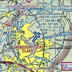
| Sectional chart |
|---|
|
 Download PDF
of official airport diagram from the FAA
| Airport distance calculator |
|---|
|
|
| Sunrise and sunset |
|---|
|
Times for 27-Jul-2026
| | Local
(UTC-4) | | Zulu
(UTC) |
|---|
| Morning civil twilight | | 05:07 | | 09:07 |
| Sunrise | | 05:39 | | 09:39 |
| Sunset | | 20:14 | | 00:14 |
| Evening civil twilight | | 20:46 | | 00:46 |
|
| Current date and time |
|---|
| Zulu (UTC) | 27-Jul-2026 07:14:41 |
|---|
| Local (UTC-4) | 27-Jul-2026 03:14:41 |
|---|
|
| METAR |
|---|
| KCEF | 270655Z AUTO 00000KT 10SM CLR 14/13 A2981 RMK AO2 SLP097 T01380125 CHINO RWY23 $
|
KBAF
8nm W | 270653Z AUTO 00000KT 10SM CLR 15/13 A2984 RMK AO2 SLP103 T01500128
|
KBDL
17nm SW | 270651Z 32003KT 10SM FEW070 FEW250 14/13 A2984 RMK AO2 SLP103 T01440133 $
|
|
| TAF |
|---|
| KCEF | 270000Z 2700/2806 VRB06KT 9999 FEW060 QNH2978INS BECMG 2715/2716 18009KT 9999 SCT050 BKN150 QNH2972INS TEMPO 2721/2802 8000 -SHRA BKN050 BKN120 BECMG 2804/2805 16006KT 9999 FEW015 BKN030 BKN150 QNH2969INS TX29/2719Z TN13/2710Z LAST NO AMDS AFT 2701 NEXT 2712
|
KBAF
8nm W | 270400Z 2704/2810 22006KT 9999 FEW050 QNH2982INS BECMG 2720/2721 12006KT 9999 SCT050 QNH2980INS TX29/2722Z TN14/2710Z
|
KBDL
17nm SW | 270554Z 2706/2812 00000KT P6SM FEW250 FM271700 17006KT P6SM SCT100 FM271900 19006KT P6SM VCSH BKN100 FM280100 18006KT P6SM BKN100
|
|
| NOTAMs |
|---|
NOTAMs are issued by the DoD/FAA and will open in a separate window not controlled by AirNav.
|
|


