FAA INFORMATION EFFECTIVE 16 APRIL 2026
Location
| FAA Identifier: | COS |
| Lat/Long: | 38-48-20.9400N 104-42-02.7950W
38-48.349000N 104-42.046583W
38.8058167,-104.7007764
(estimated) |
| Elevation: | 6187 ft. / 1885.8 m (surveyed) |
| Variation: | 08E (2020) |
| From city: | 6 miles SE of COLORADO SPRINGS, CO |
| Time zone: | UTC -6 (UTC -7 during Standard Time) |
| Zip code: | 80916 |
Airport Operations
| Airport use: | Open to the public |
| Activation date: | 04/1940 |
| Control tower: | yes |
| ARTCC: | DENVER CENTER |
| FSS: | DENVER FLIGHT SERVICE STATION |
| NOTAMs facility: | COS (NOTAM-D service available) |
| Attendance: | CONTINUOUS |
| Wind indicator: | yes |
| Segmented circle: | no |
| Lights: | ACTVT REIL RWY 13 & 31, 17R - CTC COS ATCT. |
| Beacon: | white-green (lighted land airport)
Operates sunset to sunrise. |
| Landing fee: | yes |
| Fire and rescue: | ARFF index C |
| International operations: | customs landing rights airport |
Airport Communications
| UNICOM: | 122.95 |
| ATIS: | 125.0 254.3 |
| WX ASOS: | 125.0 (719-694-7502) |
| SPRINGS GROUND: | 121.7 348.6 |
| SPRINGS TOWER: | 119.9 360.6 133.15 335.55 |
| SPRINGS APPROACH: | 124.0 257.875 120.6 |
| SPRINGS DEPARTURE: | 124.0 257.875 |
| CLEARANCE DELIVERY: | 134.45 363.125 |
| CLASS C: | 124.0 257.875 |
| COMD POST: | 318.05 328.025 |
| DUNNN STAR: | 124.0 257.875 |
| EMERG: | 121.5 243.0 |
| PMSV METRO: | 226.1 |
| PTD: | 122.85 372.2 |
| WX AWOS-3 at FCS (8 nm S): | 125.0 (719-637-9696) |
| WX AWOS-3PT at FLY (10 nm NE): | 118.450 (719-683-5371) |
| WX ASOS at CO90 (19 nm E): | 125.0 (719-637-9696) |
- PTD LTD TO PETERSON RAMP ONLY.
- COMMUNICATIONS PRVDD BY DENVER RADIO ON FREQ 122.4 (BLACK FOREST RCO).
- SAID IN USE. OPERATE TRANSPONDERS WITH ALTITUDE REPORTING MODE AND ADS-B (IF EQUIPPED) ENABLED ON ALL AIRPORT SURFACES.
Nearby radio navigation aids
| VOR radial/distance | | VOR name | | Freq | | Var |
|---|
| FCSr007/8.0 | | BUTTS VOR/DME | | 108.80 | | 12E |
| BRKr193/8.9 | | BLACK FOREST VOR/DME | | 112.50 | | 08E |
| PUBr329/33.2 | | PUEBLO VORTAC | | 116.70 | | 08E |
| NDB name | | Hdg/Dist | | Freq | | Var | | ID |
|---|
| PETEY | | 358/6.7 | | 407 | | 08E | | CO | -.-. --- |
| IRONHORSE | | 010/8.0 | | 335 | | 08E | | IHS | .. .... ... |
Airport Services
| Fuel available: | 100LL JET-A |
| Parking: | hangars and tiedowns |
| Airframe service: | MAJOR |
| Powerplant service: | MAJOR |
| Bottled oxygen: | NONE |
| Bulk oxygen: | HIGH |
Runway Information
Runway 17L/35R
| Dimensions: | 13500 x 150 ft. / 4115 x 46 m |
| Surface: | concrete/grooved, in good condition |
| Weight bearing capacity: | | Single wheel: | 120.0 | | Double wheel: | 250.0 | | Double tandem: | 550.0 | | Dual double tandem: | 1120.0 |
|
| Runway edge lights: | high intensity |
| RUNWAY 17L | | RUNWAY 35R |
| Latitude: | 38-48.965213N | | 38-46.741855N |
| Longitude: | 104-41.144022W | | 104-41.147860W |
| Elevation: | 6187.0 ft. | | 6102.7 ft. |
| Traffic pattern: | left | | left |
| Runway heading: | 172 magnetic, 180 true | | 352 magnetic, 000 true |
| Declared distances: | TORA:13501 TODA:13501 ASDA:13501 LDA:13501 | | TORA:13501 TODA:13501 ASDA:13501 LDA:13501 |
| Markings: | precision, in good condition | | precision, in good condition |
| Visual slope indicator: | 4-light PAPI on left (3.00 degrees glide path) | | 4-light PAPI on right (3.00 degrees glide path) |
| RVR equipment: | touchdown, rollout | | touchdown, rollout |
| Approach lights: | MALSR: 1,400 foot medium intensity approach lighting system with runway alignment indicator lights | | |
| Runway end identifier lights: | no | | yes |
| Centerline lights: | yes | | yes |
| Touchdown point: | yes, lighted | | yes, lighted |
| Instrument approach: | ILS/DME | | ILS/DME |
Runway 17R/35L
| Dimensions: | 11022 x 150 ft. / 3360 x 46 m |
| Surface: | asphalt/grooved, in good condition |
| Weight bearing capacity: | | Single wheel: | 120.0 | | Double wheel: | 250.0 | | Double tandem: | 550.0 | | Dual double tandem: | 1120.0 |
|
| Runway edge lights: | high intensity |
| RUNWAY 17R | | RUNWAY 35L |
| Latitude: | 38-49.444520N | | 38-47.629468N |
| Longitude: | 104-42.953680W | | 104-42.956047W |
| Elevation: | 6176.4 ft. | | 6045.0 ft. |
| Traffic pattern: | left | | left |
| Runway heading: | 172 magnetic, 180 true | | 352 magnetic, 000 true |
| Declared distances: | TORA:11022 TODA:11022 ASDA:11022 LDA:11022 | | TORA:11022 TODA:11022 ASDA:11022 LDA:11022 |
| Markings: | precision, in good condition | | precision, in good condition |
| Visual slope indicator: | 4-light PAPI on left (3.00 degrees glide path) | | 4-light PAPI on left (3.00 degrees glide path) |
| RVR equipment: | touchdown, rollout | | touchdown, rollout |
| Approach lights: | | | MALSR: 1,400 foot medium intensity approach lighting system with runway alignment indicator lights |
| Runway end identifier lights: | yes | | |
| Touchdown point: | yes, no lights | | yes, no lights |
| Instrument approach: | | | ILS |
Runway 13/31
| Dimensions: | 8270 x 150 ft. / 2521 x 46 m |
| Surface: | asphalt/grooved, in good condition |
| Weight bearing capacity: | | Single wheel: | 120.0 | | Double wheel: | 171.0 | | Double tandem: | 279.0 | | Dual double tandem: | 691.0 |
|
| Runway edge lights: | medium intensity |
| RUNWAY 13 | | RUNWAY 31 |
| Latitude: | 38-49.389345N | | 38-48.424907N |
| Longitude: | 104-42.921280W | | 104-41.692190W |
| Elevation: | 6173.1 ft. | | 6137.1 ft. |
| Traffic pattern: | left | | left |
| Runway heading: | 127 magnetic, 135 true | | 307 magnetic, 315 true |
| Displaced threshold: | no | | 356 ft. |
| Declared distances: | TORA:8270 TODA:8270 ASDA:8270 LDA:8270 | | TORA:8270 TODA:8270 ASDA:8270 LDA:7914 |
| Markings: | nonprecision, in good condition | | nonprecision, in good condition |
| Visual slope indicator: | 4-light PAPI on right (3.00 degrees glide path) | | 4-light PAPI on left (3.04 degrees glide path) |
| Runway end identifier lights: | yes | | yes |
| Touchdown point: | yes, no lights | | yes, no lights |
| Obstructions: | none | | 10 ft. hill, 400 ft. from runway, 340 ft. left of centerline, 20:1 slope to clear |
Airport Ownership and Management from official FAA records
| Ownership: | Publicly-owned |
| Owner: | CITY OF COLORADO SPRINGS
7770 MILTON E PROBY PKWY, SUITE 50
COLORADO SPRINGS, CO 80916
Phone (719) 550-1919 |
| Manager: | ALEXANDRU KOVACS
7770 MILTON E PROBY PKWY, SUITE 50
COLORADO SPRINGS, CO 80916
Phone (719) 550-1900 |
Additional Remarks
| A39-17L/35R | PCR VALUE: 1060/R/B/W/T |
| A39-13/31 | PCR VALUE: 460/F/C/X/T |
| A39-17R/35L | PCR VALUE: 1160/F/A/X/T |
| - | CUSTOMS AVBL FOR ALL MIL/CIVILIAN ACFT. CONTACT US CUSTOMS 719-574-6607. |
| - | OIL: O-133-148-156(MIL). |
| - | PORTIONS OF TWYS A, B, E, F, G, AND M ARE BLOCKED FROM VIEW FROM THE TOWER BY OBSTRUCTIONS. PORTIONS OF TWY C AND RY 17R/35L ARE BLOCKED FROM VIEW FROM THE TOWER WHEN THE INFIELD MILITARY OPERATING SFC IS OCCUPIED BY A C17 OR C5. |
| - | WATERFOWL AND MIGRATORY BIRD ACTIVITY ON AND INVOF ARPT. |
| - | A/DACG RAMP LIGHT 140 FT AGL. |
| - | BE ALERT; INTENSIVE USAF STUDENT TRAINING INVOF COLORADO SPRINGS & PUEBLO COLORADO. |
| - | CTN: ACFT WITH WINGSPAN GREATER THAN 117 FT; WHEN TAXI ON CNTRLN A2, A3, A4, USE OVERSTEER IN TURNS DUE TO INSUFFICIENT CORNER FILLETS IN PAVEMENT. |
| - | PPR RQR FOR ALL TRAN ACFT - CTC AFLD MGT DSN 834-4778/9 C719-556-4778/9. AFLD MGMT OPR 1300-0500++, CLSD HOL. |
| - | TURBO JET TRNG FLTS PROHIBITED 2300-0600. |
| - | MILITARY: TRAN ALERT-FORT CARSON ARRIVAL/DEPARTURE AIR CONTROL GROUP (ADACG) MSN, CTC DSN 532-8002/3 OR C719-503-8002/3. ALL TRAN ACFT CTC HIGH COUNTRY 30 MIN PRIOR TO ARR. TRAN ACFT CTC COLORADO SPRINGS RGNL COMD POST (CALLSIGN: HIGH COUNTRY) WITH ATA AND ATD. |
| - | MISC-FAA ATCT WILL PROVIDE MIL RCR O/R. CARGO AND PAX SVC AVBL ONLY ON PETERSON RAMP 1330-2330Z++ WKD. CLSD WKEND AND HOL UNLESS COORD 72 HR PRIOR. CTC PAX SVC AT DSN 834-4521/9021 OR C719-556-4521/9021. |
| - | FUEL-A++(MIL) |
| - | MISC-WX OPR H24 INCL WKEND; ++ CTC 834-4337, C 719-556-4337. OBSN AND FCST BY NWS KCOS. LLWASL KPEF WATCH, WARNING, ADZY. |
| - | WHEN CROSSING RWY 17R/35L FROM A1 TO B1 OR B1 TO A1, BE AWARE YOU WILL NOT SEE A1 OR B1 DEPENDING ON DIRECTION CROSSING UNTIL YOU CREST RWY 17R/35L. WHEN CROSSING FROM A1 TO B1 TRAVEL NE AND FROM B1 TO A1 TRAVEL SW. |
| - | AF: ACFT TRANSPORTING HAZ CARGO CTC AFLD MGMT ON 318.05 30 MIN PRIOR TO ARR. |
| - | MILITARY: RSTD: DUE TO LIMITED PRKG AND POTENTIAL TO DMG LGT, UNSECURED ACFT, MOBILITY ACFT ARE NOT PERMITTED TO USE COLORADO SPRINGS FBO UNLESS FBO CAN GUARANTEE SUFFICIENT PRKG CLNC THAT BLAST FM ENG THRUST AND REVERSE THRUST WILL NOT IMPACT OTR ACFT, GND PSNL, OR EQPT. |
| - | B52 OPNS PROHIBITED. |
| - | LGTD WDI APCH RWY 17L/35R, 17R/35L & 13/31. |
| - | JASU: 2(AM32A-95) 2MA32A-60A 2(MA32-86A) 1(SGNC) 2(B809D-GENERATORS). |
Instrument Procedures
NOTE: All procedures below are presented as PDF files. If you need a reader for these files, you should download the free Adobe Reader.NOT FOR NAVIGATION. Please procure official charts for flight.
FAA instrument procedures published for use from 16 April 2026 at 0901Z to 14 May 2026 at 0900Z.
STARs - Standard Terminal Arrivals |
|---|
| DEBERRY FIVE | |
download (216KB) |
| OZZZY FIVE (RNAV) | |
download (188KB) |
IAPs - Instrument Approach Procedures |
|---|
| ILS OR LOC RWY 17L | |
download (398KB) |
| ILS OR LOC RWY 35L | |
download (389KB) |
| ILS OR LOC RWY 35R | |
download (462KB) |
| ILS RWY 17L (SA CAT I - II) | |
download (379KB) |
| ILS RWY 35L (SA CAT II) | |
download (361KB) |
| RNAV (RNP) Z RWY 17L | |
download (372KB) |
| RNAV (RNP) Z RWY 17R | |
download (387KB) |
| RNAV (RNP) Z RWY 35L | |
download (380KB) |
| RNAV (RNP) Z RWY 35R | |
download (343KB) |
| RNAV (GPS) RWY 31 | |
download (293KB) |
| RNAV (GPS) Y RWY 17L | |
download (340KB) |
| RNAV (GPS) Y RWY 17R | |
download (324KB) |
| RNAV (GPS) Y RWY 35L | |
download (363KB) |
| RNAV (GPS) Y RWY 35R | |
download (326KB) |
| VOR RWY 17L | |
download (321KB) |
| NDB RWY 35L | |
download (380KB) |
| NOTE: Special Alternate Minimums apply | |
download (144KB) |
Departure Procedures |
|---|
| SPRINGS SIX | |
2 pages:
[1] [2] (411KB) |
| NOTE: Special Take-Off Minimums/Departure Procedures apply | |
download (175KB) |
Other nearby airports with instrument procedures:
KFCS - Butts Army Airfield (Fort Carson) (8 nm S)
KFLY - Meadow Lake Airport (10 nm NE)
1V6 - Fremont County Airport (30 nm SW)
KPUB - Pueblo Memorial Airport (32 nm S)
KAPA - Centennial Airport (46 nm N)
|
|

Road maps at:
MapQuest
Bing
Google
| Aerial photo |
|---|
WARNING: Photo may not be current or correct
 Photo by Mitch Bowers - Imagewerx.us Aerial Photography
Photo taken 21-Mar-2018
looking northwest from 9000MSL.
Photo by Mitch Bowers - Imagewerx.us Aerial Photography
Photo taken 21-Mar-2018
looking northwest from 9000MSL.
Do you have a better or more recent aerial photo of City of Colorado Springs Municipal Airport that you would like to share? If so, please send us your photo.
|
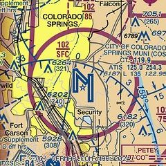
| Sectional chart |
|---|
|
CAUTION: Diagram may not be current
 Download PDF
of official airport diagram from the FAA
| Airport distance calculator |
|---|
|
|
| Sunrise and sunset |
|---|
|
Times for 14-May-2026
| | Local
(UTC-6) | | Zulu
(UTC) |
|---|
| Morning civil twilight | | 05:18 | | 11:18 |
| Sunrise | | 05:48 | | 11:48 |
| Sunset | | 20:02 | | 02:02 |
| Evening civil twilight | | 20:32 | | 02:32 |
|
| Current date and time |
|---|
| Zulu (UTC) | 14-May-2026 07:44:10 |
|---|
| Local (UTC-6) | 14-May-2026 01:44:10 |
|---|
|
| METAR |
|---|
| KCOS | 140654Z 03006KT 10SM FEW120 BKN160 OVC210 14/05 A3002 RMK AO2 SLP090 T01440050 402670094
|
KCWN
8nm SW | 140655Z AUTO 29010G22KT 10SM OVC200 22/M03 A3003 RMK AO2 SLP973 T02201027 402530115 $
|
KFCS
9nm S | 140655Z AUTO 25005KT 10SM FEW210 20/02 A2998 RMK AO2 SLP083 T01970021 402830086 $
|
KFLY
10nm NE | 140735Z AUTO 30009G22KT 10SM CLR 18/M01 A3006 RMK AO2 T01831008
|
KAFF
11nm NW | 140655Z AUTO 26017G23KT 10SM FEW130 21/M02 A3000 RMK AO2 SLP054 T02071024 402610085
|
|
| TAF |
|---|
| KCOS | 140520Z 1406/1506 36008KT P6SM FEW140 SCT220 WS020/20030KT FM141200 29007KT P6SM BKN140 FM141600 23011KT P6SM SCT220 FM141900 22012G22KT P6SM FEW120 BKN220 FM150000 35012KT P6SM SCT100
|
KFCS
9nm S | 140400Z 1404/1510 29009KT 9999 SCT120 QNH3001INS BECMG 1407/1408 29009KT 9999 SCT120 WS010/27030KT QNH2998INS BECMG 1413/1414 26009KT 9999 VCSH BKN160 520209 QNH2997INS BECMG 1417/1418 26009KT 9999 NSW SCT180 QNH2988INS BECMG 1503/1504 33012G18KT 9999 VCSH OVC140 QNH2996INS BECMG 1507/1508 33009KT 9999 NSW SCT120 QNH2997INS TX29/1420Z TN13/1412Z
|
KAFF
11nm NW | 132145Z 1319/1501 16012G18KT 9999 SCT140 QNH3015INS BECMG 1319/1320 17015G25KT 9999 VCSH BKN130 520009 QNH3006INS DRY MICROBURST CONDS EXIST TEMPO 1320/1402 VRB20G35KT -SHRA VCTS BKN120CB BECMG 1401/1402 16012KT 9999 NSW BKN130 520309 QNH3003INS BECMG 1406/1407 27025G35KT 9999 BKN150 560009 QNH2997INS BECMG 1414/1415 27015G25KT 9999 SCT150 530009 QNH2999INS BECMG 1418/1419 28014KT 9999 FEW150 SCT200 520009 QNH2993INS WND 240V320 BECMG 1421/1422 35012G18KT 9999 SCT140 QNH2993INS TX27/1321Z TN10/1
|
|
| NOTAMs |
|---|
NOTAMs are issued by the DoD/FAA and will open in a separate window not controlled by AirNav.
|
|


