FAA INFORMATION EFFECTIVE 09 JULY 2026
Location
| FAA Identifier: | DSM |
| Lat/Long: | 41-32-02.3020N 093-39-47.0600W
41-32.038367N 093-39.784333W
41.5339728,-93.6630722
(estimated) |
| Elevation: | 957.9 ft. / 292.0 m (surveyed) |
| Variation: | 01E (2020) |
| From city: | 3 miles SW of DES MOINES, IA |
| Time zone: | UTC -5 (UTC -6 during Standard Time) |
| Zip code: | 50321 |
Airport Operations
| Airport use: | Open to the public |
| Activation date: | 04/1940 |
| Control tower: | yes |
| ARTCC: | MINNEAPOLIS CENTER |
| FSS: | FORT DODGE FLIGHT SERVICE STATION |
| NOTAMs facility: | DSM (NOTAM-D service available) |
| Attendance: | CONTINUOUS |
| Wind indicator: | lighted |
| Segmented circle: | no |
| Beacon: | white-green (lighted land airport)
Operates sunset to sunrise. |
| Fire and rescue: | ARFF index C |
| International operations: | customs landing rights airport
FLIGHT NOTIFICATION SERVICE (ADCUS) AVBL MON-FRI
0830-1700. FOR SAT; SUN; HOLS & NIGHT CUSTOMS SVC
MAKE APPOINTMENTS MON-FRI 0830-1700. AT LEAST 3 HR
ADVANCE NOTICE RQRD. |
Airport Communications
| UNICOM: | 122.95 |
| ATIS: | 119.55 |
| WX ASOS: | 119.55 (515-218-1035) |
| DES MOINES GROUND: | 121.9 348.6 |
| DES MOINES TOWER: | 118.3 257.8 |
| DES MOINES APPROACH: | 123.9 307.15 120.45 135.2 350.3 360.7 |
| DES MOINES DEPARTURE: | 123.9 307.15 120.45 350.3 |
| CLEARANCE DELIVERY: | 134.15 317.55 |
| CLASS C: | 123.9 307.15 |
| CLASS C/S: | 120.45 135.2 350.3 360.7 |
| EMERG: | 121.5 243.0 |
| IC: | 118.3 121.9 123.9 257.8 307.15 348.6 |
| WX AWOS-3 at IKV (10 nm NE): | 119.175 (515-965-5764) |
- CTC GND CTL ON 121.9 PRIOR TO PUSHBACK ON THE TRML APN. ADVISE TWR IF DE-ICING IS REQD.
Nearby radio navigation aids
| VOR radial/distance | | VOR name | | Freq | | Var |
|---|
| DSMr347/5.8 | | DES MOINES VORTAC | | 117.50 | | 07E |
| TNUr236/29.0 | | NEWTON VOR/DME | | 112.50 | | 03E |
Airport Services
| Fuel available: | 100LL JET-A |
| Parking: | hangars and tiedowns |
| Airframe service: | MAJOR |
| Powerplant service: | MAJOR |
| Bottled oxygen: | HIGH/LOW |
| Bulk oxygen: | HIGH/LOW |
Runway Information
Runway 5/23
| Dimensions: | 9004 x 150 ft. / 2744 x 46 m |
| Surface: | concrete, in excellent condition |
| Weight bearing capacity: | | Single wheel: | 100.0 | | Double wheel: | 190.0 | | Double tandem: | 360.0 | | Dual double tandem: | 850.0 |
|
| Runway edge lights: | high intensity |
| RUNWAY 5 | | RUNWAY 23 |
| Latitude: | 41-31.402073N | | 41-32.276968N |
| Longitude: | 093-40.626787W | | 093-39.034052W |
| Elevation: | 915.5 ft. | | 937.0 ft. |
| Traffic pattern: | left | | left |
| Runway heading: | 053 magnetic, 054 true | | 233 magnetic, 234 true |
| Markings: | nonprecision, in good condition | | nonprecision, in good condition |
| Visual slope indicator: | 4-light PAPI on left (3.00 degrees glide path) | | 4-light PAPI on left (3.00 degrees glide path)
PAPI UNUSBL BYD 9 DEGS RIGHT OF CNTRLN. |
| RVR equipment: | touchdown | | rollout |
| Approach lights: | MALSR: 1,400 foot medium intensity approach lighting system with runway alignment indicator lights | | |
| Runway end identifier lights: | yes | | yes |
| Touchdown point: | yes, no lights | | yes, no lights |
| Instrument approach: | ILS/DME | | |
| Obstructions: | none | | 67 ft. pole, lighted, 2322 ft. from runway, 375 ft. left of centerline, 34:1 slope to clear |
Runway 13/31
| Dimensions: | 9001 x 150 ft. / 2744 x 46 m |
| Surface: | concrete/grooved, in excellent condition |
| Weight bearing capacity: | | Single wheel: | 100.0 | | Double wheel: | 200.0 | | Double tandem: | 360.0 | | Dual double tandem: | 850.0 |
|
| Runway edge lights: | high intensity |
| RUNWAY 13 | | RUNWAY 31 |
| Latitude: | 41-32.736328N | | 41-31.738030N |
| Longitude: | 093-40.467220W | | 093-39.009272W |
| Elevation: | 912.6 ft. | | 957.8 ft. |
| Traffic pattern: | left | | right |
| Runway heading: | 131 magnetic, 132 true | | 311 magnetic, 312 true |
| Declared distances: | TORA:9001 TODA:9001 ASDA:9001 LDA:9001 | | TORA:9001 TODA:9001 ASDA:9001 LDA:9001 |
| Markings: | precision, in good condition | | precision, in good condition |
| Visual slope indicator: | 4-light PAPI on right (3.00 degrees glide path) | | 4-light PAPI on left (3.00 degrees glide path) |
| RVR equipment: | touchdown, midfield, rollout | | touchdown, midfield, rollout |
| Approach lights: | MALSR: 1,400 foot medium intensity approach lighting system with runway alignment indicator lights | | ALSF2: standard 2,400 foot high intensity approach lighting system with centerline sequenced flashers (category II or III) |
| Centerline lights: | yes | | yes |
| Touchdown point: | yes, no lights | | yes, lighted |
| Instrument approach: | ILS/DME | | ILS/DME |
Airport Ownership and Management from official FAA records
| Ownership: | Publicly-owned |
| Owner: | DES MOINES AIRPORT AUTHORITY
5800 FLEUR DRIVE, SUITE 207, ROOM 201
DES MOINES, IA 50321
Phone 515-256-5100 |
| Manager: | MR. BRIAN MULCAHY
5800 FLEUR DRIVE, SUITE 207
DES MOINES, IA 50321-2854
Phone 515-256-5100
EXEC DIR |
Additional Remarks
| A39-05/23 | PCR VALUE: 696/R/D/W/T |
| A39-13/31 | PCR VALUE: 696/R/D/W/T |
| - | CONTR FUEL - 515-256-5330. |
| - | BIRDS ON & INVOF ARPT. |
| - | INFORMAL NOISE ABATEMENT PROCEDURES IN EFFECT. EXPECT ATC TO ASSIGN PREFERRED RY. |
| - | IANG SOUTH RAMP PCN 78 R/B/W/T. IANG WEST RAMP PCN 87 R/B/W/T. |
| - | MAX ACFT WT SOUTH GA APRN 170,000 LBS ALL OTHER FBO APRN 80,000 LBS. |
| - | RWY 05 APCH END HAS LTD VIS FROM THE TWR. TWR CANNOT EASILY ID IF AN ACFT IS OVER THE HOLD SHORT LINE AT TWY P7. RWY 05 ARRIVALS - USE CTN AND ENSURE YOU ARE CORRECTLY LINED UP WITH RWY 05 AND NOT TWY P. |
| - | CROSS BLEED ENGINE STARTS ON AIR CARRIER RAMP PROHIBITED. |
| - | USE CAUTION WHEN LNDG OVER RAISED LIGHTS IN THE OVERRUNS AND RWY THLDS AT DSM. |
| - | ARNG RAMP AVBL FOR MIL AND MIL-CONTRACTED ACFT FOR OFFL BUS ONLY WITH LTD SUPPORT. PPR; CTC DSN 261-8360/8361, C515-261-8360/8361. FBO WILL PROVIDE CONTRACT FUEL. MIL CREWS CAN CTC HAWKI ON 252.9 |
| - | A321 AIRCRAFT LTD TO 190,000 LBS ON RWY 5-23 AND TWY P. A321 EXCEEDING 190,000 LBS WO ARPT AUTH WAIVER REQ ATCT PRVD 13-31. |
| - | TERMINAL APRON TAXILANE ADG III AC ONLY, ADG IV AC AT GATE 25 ONLY. |
| - | MODERN AVIATION FBO LCTD AT NORTH GA APRON. |
| - | TERMINAL APRON TAXILANE ADG III AC ONLY, ADG IV AC AT GATE A4 ONLY. |
| - | TRML APRON TAXILANE ADG III (ACFT WINGSPAN LESS THAN 118 FT) ONLY, ADG IV (ACFT WINGSPAN LESS THAN 172 FT) ACFT AT GATE A4 ONLY. |
| - | TERMINAL APRON DE-ICE SPOT N2 AND ASSOCIATED TAXILANE LIMITED TO ADGII UNLESS COORDINATED WITH IDS 129.875. |
| - | NO TAXI BETWEEN GATES 24 AND 26. |
| - | NO TAXI TO TRML GATES 21/23/25 FROM TXY D1 WHEN AN AIRCRAFT IS PARKED AT REMOTE SPOT R6 - REQUEST TXY E. |
| - | ENTER TERMINAL DE-ICE PAD QUEUE FROM TAXILANE N, DO NOT ENTER PAD FROM TAXILANE N4. |
| - | TWY P E OF TWY D WINGTIP CLEARANCE LIMITED TO 121.5 FT, CAUTION ADVISED FOR ADG V AND LARGER AIRCRAFT. |
Instrument Procedures
NOTE: All procedures below are presented as PDF files. If you need a reader for these files, you should download the free Adobe Reader.NOT FOR NAVIGATION. Please procure official charts for flight.
FAA instrument procedures published for use from 09 July 2026 at 0901Z to 06 August 2026 at 0900Z.
IAPs - Instrument Approach Procedures |
|---|
| ILS OR LOC RWY 05 | |
download (304KB) |
| ILS OR LOC RWY 13 | |
download (288KB) |
| ILS OR LOC RWY 31 | |
download (279KB) |
| ILS RWY 31 (SA CAT I) | |
download (249KB) |
| ILS RWY 31 (CAT II - III) | |
download (245KB) |
| RNAV (GPS) RWY 05 | |
download (241KB) |
| RNAV (GPS) RWY 13 | |
download (220KB) |
| RNAV (GPS) RWY 23 | |
download (234KB) |
| RNAV (GPS) RWY 31 | |
download (233KB) |
| VOR RWY 23 | |
download (236KB) |
| NOTE: Special Alternate Minimums apply | |
download (146KB) |
Departure Procedures |
|---|
| DES MOINES TWO | |
download (173KB) |
| DES MOINES TWO | |
download (173KB) |
| NOTE: Special Take-Off Minimums/Departure Procedures apply | |
download (429KB) |
Other nearby airports with instrument procedures:
KIKV - Ankeny Regional Airport (10 nm NE)
3Y3 - Winterset Municipal Airport (19 nm SW)
KAMW - Ames Municipal Airport (28 nm N)
KPRO - Perry Municipal Airport (28 nm NW)
KOXV - Knoxville Municipal Airport (28 nm SE)
|
|

Road maps at:
MapQuest
Bing
Google
| Aerial photo |
|---|
WARNING: Photo may not be current or correct

Do you have a better or more recent aerial photo of Des Moines International Airport that you would like to share? If so, please send us your photo.
|
| Sectional chart |
|---|
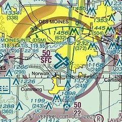
|
CAUTION: Diagram may not be current
 Download PDF
of official airport diagram from the FAA
| Airport distance calculator |
|---|
|
|
| Sunrise and sunset |
|---|
|
Times for 31-Jul-2026
| | Local
(UTC-5) | | Zulu
(UTC) |
|---|
| Morning civil twilight | | 05:38 | | 10:38 |
| Sunrise | | 06:09 | | 11:09 |
| Sunset | | 20:33 | | 01:33 |
| Evening civil twilight | | 21:04 | | 02:04 |
|
| Current date and time |
|---|
| Zulu (UTC) | 31-Jul-2026 07:34:06 |
|---|
| Local (UTC-5) | 31-Jul-2026 02:34:06 |
|---|
|
| METAR |
|---|
| KDSM | 310654Z 12009KT 10SM OVC075 22/21 A2988 RMK AO2 SLP111 T02170206
|
KIKV
10nm NE | 310715Z AUTO 14006G12KT 10SM BKN035 BKN042 OVC080 22/21 A2990 RMK AO2
|
|
| TAF |
|---|
| KDSM | 310520Z 3106/0106 11009KT P6SM FEW040 OVC080 FM310700 16009KT 6SM -SHRA OVC090 PROB30 3107/3110 4SM -TSRA OVC025CB FM311000 15010KT P6SM OVC025 PROB30 3110/3112 4SM -SHRA OVC008 FM311400 19010KT P6SM BKN007 FM311700 27010KT P6SM BKN014 PROB30 3118/3122 4SM -TSRA OVC008CB FM312300 32015G26KT P6SM BKN014
|
|
| NOTAMs |
|---|
NOTAMs are issued by the DoD/FAA and will open in a separate window not controlled by AirNav.
|
|


