FAA INFORMATION EFFECTIVE 14 MAY 2026
Location
| FAA Identifier: | FAY |
| Lat/Long: | 34-59-28.3600N 078-52-48.9870W
34-59.472667N 078-52.816450W
34.9912111,-78.8802742
(estimated) |
| Elevation: | 189.4 ft. / 57.7 m (surveyed) |
| Variation: | 07W (1985) |
| From city: | 3 miles S of FAYETTEVILLE, NC |
| Time zone: | UTC -4 (UTC -5 during Standard Time) |
| Zip code: | 28306 |
Airport Operations
| Airport use: | Open to the public |
| Activation date: | 05/1949 |
| Control tower: | yes |
| ARTCC: | WASHINGTON CENTER |
| FSS: | RALEIGH FLIGHT SERVICE STATION |
| NOTAMs facility: | FAY (NOTAM-D service available) |
| Attendance: | 0600-0000 |
| Wind indicator: | lighted |
| Segmented circle: | no |
| Lights: | SS-SR |
| Beacon: | white-green (lighted land airport)
Operates sunset to sunrise. |
| Fire and rescue: | ARFF index B |
Airport Communications
| UNICOM: | 122.95 |
| ATIS: | 121.25 |
| WX ASOS: | 121.25 (910-484-1546) |
| FAYETTEVILLE GROUND: | 121.7 348.6 |
| FAYETTEVILLE TOWER: | 118.3 269.2 |
| FAYETTEVILLE APPROACH: | 125.175 ;321-060 127.8 ;231-320 133.0 ;061-230 285.575 ;321-060 290.25 ;061-230 343.725 ;231-320 |
| FAYETTEVILLE DEPARTURE: | 125.175 ;321-060 127.8 ;231-320 133.0 ;061-230 285.575 ;321-060 290.25 ;061-230 343.725 ;231-320 |
| CLASS C: | 125.175 ;321-060 127.8 ;231-320 133.0 ;061-230 285.575 ;321-060 290.25 ;061-230 343.725 ;231-320 |
| EMERG: | 121.5 243.0 |
| IC: | 133.0 ;061-230 290.25 ;061-230 |
Nearby radio navigation aids
| VOR radial/distance | | VOR name | | Freq | | Var |
|---|
| FAY at field | | FAYETTEVILLE VOR/DME | | 114.85 | | 04W |
| SDZr114/37.3 | | SANDHILLS VORTAC | | 111.80 | | 03W |
| NDB name | | Hdg/Dist | | Freq | | Var | | ID |
|---|
| CLINTON | | 281/25.5 | | 412 | | 09W | | CTZ | -.-. - --.. |
Airport Services
| Fuel available: | 100LL JET-A |
| Parking: | hangars and tiedowns |
| Airframe service: | MAJOR |
| Powerplant service: | MAJOR
MAJOR POWER PLANT REPAIRS AVBL FOR PISTON ENGINES ONLY. |
| Bottled oxygen: | NONE |
| Bulk oxygen: | NONE |
Runway Information
Runway 4/22
| Dimensions: | 7709 x 150 ft. / 2350 x 46 m |
| Surface: | asphalt/grooved, in good condition |
| Weight bearing capacity: | | Single wheel: | 109.0 | | Double wheel: | 178.0 | | Double tandem: | 321.0 |
|
| Runway edge lights: | high intensity |
| RUNWAY 4 | | RUNWAY 22 |
| Latitude: | 34-59.060722N | | 35-00.147857N |
| Longitude: | 078-53.220525W | | 078-52.421020W |
| Elevation: | 183.1 ft. | | 157.7 ft. |
| Traffic pattern: | left | | left |
| Runway heading: | 038 magnetic, 031 true | | 218 magnetic, 211 true |
| Displaced threshold: | 598 ft. | | 303 ft. |
| Declared distances: | TORA:7709 TODA:7709 ASDA:7006 LDA:6408 | | TORA:7709 TODA:7709 ASDA:6711 LDA:6408 |
| Markings: | precision, in good condition | | precision, in good condition |
| Visual slope indicator: | 4-light PAPI on right (3.13 degrees glide path) | | 4-light PAPI on left (3.00 degrees glide path) |
| RVR equipment: | touchdown | | rollout |
| Approach lights: | MALSR: 1,400 foot medium intensity approach lighting system with runway alignment indicator lights | | |
| Runway end identifier lights: | | | yes |
| Touchdown point: | yes, no lights | | yes, no lights |
| Instrument approach: | ILS/DME | | |
Runway 10/28
| Dimensions: | 4801 x 150 ft. / 1463 x 46 m |
| Surface: | asphalt, in excellent condition |
| Weight bearing capacity: | | PCN 17 /F/A/X/T | | Single wheel: | 53.0 | | Double wheel: | 75.0 |
|
| Runway edge lights: | medium intensity |
| RUNWAY 10 | | RUNWAY 28 |
| Latitude: | 34-59.269348N | | 34-59.253308N |
| Longitude: | 078-53.290210W | | 078-52.328662W |
| Elevation: | 182.9 ft. | | 183.8 ft. |
| Traffic pattern: | left | | left |
| Runway heading: | 098 magnetic, 091 true | | 278 magnetic, 271 true |
| Markings: | nonprecision, in good condition | | nonprecision, in good condition |
| Visual slope indicator: | | | 4-light PAPI on left (3.00 degrees glide path) |
| Runway end identifier lights: | yes | | yes |
| Touchdown point: | yes, no lights | | yes, no lights |
| Obstructions: | 15 ft. trees, 800 ft. from runway, 50 ft. right of centerline, 40:1 slope to clear | | 15 ft. trees, 800 ft. from runway, 90 ft. left of centerline, 40:1 slope to clear |
Airport Ownership and Management from official FAA records
| Ownership: | Publicly-owned |
| Owner: | CITY OF FAYETTEVILLE
400 AIRPORT RD SUITE 1
FAYETTEVILLE, NC 28306
Phone 910-433-1160 |
| Manager: | ANDREW LAGALA
400 AIRPORT RD SUITE 1
FAYETTEVILLE, NC 28306
Phone 910-433-1625 |
Additional Remarks
| A39-04/22 | PCR VALUE: 430/F/A/X/T |
| - | CLSD TO ALL MIL ACFT OVER 17000 LBS FOR ACR RAMP OPNS EXCP 24 HR PPR. CALL AMGR 910-433-1160 MON-FRI. |
Instrument Procedures
NOTE: All procedures below are presented as PDF files. If you need a reader for these files, you should download the free Adobe Reader.NOT FOR NAVIGATION. Please procure official charts for flight.
FAA instrument procedures published for use from 14 May 2026 at 0901Z to 11 June 2026 at 0900Z.
IAPs - Instrument Approach Procedures |
|---|
| ILS OR LOC RWY 04 | |
download (236KB) |
| RNAV (GPS) RWY 04 | |
download (216KB) |
| RNAV (GPS) RWY 10 | |
download (188KB) |
| RNAV (GPS) RWY 22 | |
download (204KB) |
| RNAV (GPS) RWY 28 | |
download (222KB) |
| LOC BC RWY 22 | |
download (219KB) |
| VOR RWY 04 | |
download (180KB) |
| VOR RWY 22 | |
download (170KB) |
| VOR RWY 28 | |
download (164KB) |
| NOTE: Special Alternate Minimums apply | |
download (166KB) |
Departure Procedures |
|---|
| MOUNTY FIVE | |
download (171KB) |
| NOTE: Special Take-Off Minimums/Departure Procedures apply | |
download (365KB) |
Other nearby airports with instrument procedures:
KFBG - Simmons Army Airfield (9 nm N)
KPOB - Pope Army Airfield (13 nm NW)
5W4 - P K Airpark (15 nm W)
KHRJ - Harnett Regional Jetport Airport (24 nm N)
KLBT - Lumberton Regional Airport (25 nm S)
|
|

Road maps at:
MapQuest
Bing
Google
| Aerial photo |
|---|
WARNING: Photo may not be current or correct
 Photo by Jake Williams Jr
Photo taken 06-Jun-2010
Photo by Jake Williams Jr
Photo taken 06-Jun-2010
Do you have a better or more recent aerial photo of Fayetteville Regional Airport/Grannis Field that you would like to share? If so, please send us your photo.
|
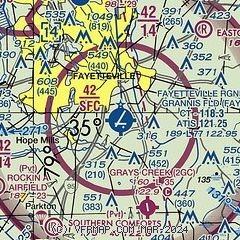
| Sectional chart |
|---|
|
 Download PDF
of official airport diagram from the FAA
| Airport distance calculator |
|---|
|
|
| Sunrise and sunset |
|---|
|
Times for 05-Jun-2026
| | Local
(UTC-4) | | Zulu
(UTC) |
|---|
| Morning civil twilight | | 05:33 | | 09:33 |
| Sunrise | | 06:03 | | 10:03 |
| Sunset | | 20:25 | | 00:25 |
| Evening civil twilight | | 20:55 | | 00:55 |
|
| Current date and time |
|---|
| Zulu (UTC) | 05-Jun-2026 21:22:05 |
|---|
| Local (UTC-4) | 05-Jun-2026 17:22:05 |
|---|
|
| METAR |
|---|
| KFAY | 052053Z 19007KT 10SM CLR 33/11 A3003 RMK AO2 SLP162 T03280106 57019
|
KFBG
8nm N | 052055Z AUTO 09003KT 10SM CLR 34/10 A3001 RMK AO2 SLP163 T03400099 57017 $
|
KPOB
12nm NW | 052055Z AUTO 28004KT 10SM CLR 34/09 A3002 RMK AO2 SLP166 T03380091 57017 $
|
|
| TAF |
|---|
| KFAY | 051720Z 0518/0618 22008KT P6SM FEW250 FM061200 23010KT P6SM FEW250
|
KFBG
8nm N | 051700Z 0517/0623 21006KT 9999 FEW150 QNH3011INS BECMG 0614/0615 25010G20KT 9999 SKC QNH3015INS TX33/0515Z TN20/0610Z
|
KPOB
12nm NW | 051700Z 0517/0623 23008KT 9999 FEW030 SCT250 QNH3000INS BECMG 0617/0618 23010G15KT 9999 OVC080 QNH2993INS BECMG 0620/0621 23008KT 9999 OVC080 QNH2991INS TX34/0520Z TN19/0609Z
|
|
| NOTAMs |
|---|
NOTAMs are issued by the DoD/FAA and will open in a separate window not controlled by AirNav.
|
|


