FAA INFORMATION EFFECTIVE 19 MARCH 2026
Location
| FAA Identifier: | GVL |
| Lat/Long: | 34-16-21.4550N 083-49-48.8140W
34-16.357583N 083-49.813567W
34.2726264,-83.8302261
(estimated) |
| Elevation: | 1276.9 ft. / 389.2 m (surveyed) |
| Variation: | 03W (1985) |
| Time zone: | UTC -4 (UTC -5 during Standard Time) |
| Zip code: | 30501 |
Airport Operations
| Airport use: | Open to the public |
| Activation date: | 04/1940 |
| Control tower: | no |
| ARTCC: | ATLANTA CENTER |
| FSS: | MACON FLIGHT SERVICE STATION |
| NOTAMs facility: | GVL (NOTAM-D service available) |
| Attendance: | DAYLIGHT HOURS |
| Wind indicator: | lighted |
| Segmented circle: | yes |
| Lights: | DUSK-DAWN. ACTVT MALSR RWY 05; HIRL RWY 05/23 - CTAF. |
| Beacon: | white-green (lighted land airport)
Operates sunset to sunrise. |
Airport Communications
| CTAF/UNICOM: | 123.075 |
| WX ASOS: | 126.475 (770-532-4687) |
| ATLANTA APPROACH: | 132.475 ;0615-2200 |
| ATLANTA DEPARTURE: | 132.475 ;0615-2200 |
| WX AWOS-3PT at JCA (15 nm SE): | 118.125 (706-387-6477) |
| WX AWOS-3PT at LZU (19 nm S): | PHONE 770-339-7753 |
| WX AWOS-3 at WDR (19 nm SE): | 118.575 (770-868-0642) |
| WX AWOS-3 at AJR (19 nm NE): | 119.175 (706-778-3675) |
- CD PRVDD BY ATLANTA ARTCC ON FREQS 134.8/307.9 (MOUNT OGLETHORPE RCAG) 2200-0615.
- APCH/DEP SVC PRVDD BY ATLANTA TRACON 0615-2200 ON FREQS 132.475/291.1 OTHER TIMES BY ATLANTA ARTCC ON FREQS 127.5/316.05 (ATHENS RCAG).
- CD PRVDD BY GAINESVILLE RCO ON FREQ 122.5 0615-2200.
Nearby radio navigation aids
| VOR radial/distance | | VOR name | | Freq | | Var |
|---|
| AHNr308/31.8 | | ATHENS VOR/DME | | 116.95 | | 00E |
| ODFr226/36.6 | | FOOTHILLS VOR/DME | | 113.40 | | 00E |
| NDB name | | Hdg/Dist | | Freq | | Var | | ID |
|---|
| BARROW COUNTY | | 334/23.5 | | 404 | | 05W | | BMW | -... -- .-- |
Airport Services
| Fuel available: | 100LL JET-A+
100LL:24 HOUR SELF SERVICE FUEL WITH CREDIT CARD. |
| Parking: | tiedowns |
| Airframe service: | MAJOR |
| Powerplant service: | MINOR |
| Bottled oxygen: | NONE |
| Bulk oxygen: | HIGH |
Runway Information
Runway 5/23
| Dimensions: | 5496 x 100 ft. / 1675 x 30 m |
| Surface: | asphalt/grooved, in excellent condition |
| Weight bearing capacity: | | Single wheel: | 45.0 | | Double wheel: | 100.0 |
|
| Runway edge lights: | high intensity |
| RUNWAY 5 | | RUNWAY 23 |
| Latitude: | 34-16.024085N | | 34-16.707892N |
| Longitude: | 083-50.275757W | | 083-49.559718W |
| Elevation: | 1274.3 ft. | | 1237.5 ft. |
| Traffic pattern: | left | | left |
| Runway heading: | 044 magnetic, 041 true | | 224 magnetic, 221 true |
| Displaced threshold: | no | | 396 ft. |
| Declared distances: | TORA:5496 TODA:5496 ASDA:5370 LDA:5370 | | TORA:5496 TODA:5496 ASDA:5496 LDA:5100 |
| Markings: | precision, in good condition | | precision, in good condition |
| Visual slope indicator: | 4-light PAPI on right (3.00 degrees glide path) | | 4-light PAPI on left (3.00 degrees glide path) |
| Approach lights: | MALSR: 1,400 foot medium intensity approach lighting system with runway alignment indicator lights | | |
| Runway end identifier lights: | no | | |
| Touchdown point: | yes, no lights | | yes, no lights |
| Instrument approach: | ILS/DME | | |
| Obstructions: | 23 ft. trees, 269 ft. from runway, 493 ft. left of centerline, 3:1 slope to clear | | 15 ft. trees, 279 ft. from runway, 479 ft. left of centerline, 5:1 slope to clear
BLDG 360 FT LEFT 0 FT - 80 FT FROM EOR. |
Runway 11/29
| Dimensions: | 4003 x 100 ft. / 1220 x 30 m |
| Surface: | asphalt, in fair condition |
| Weight bearing capacity: | | Single wheel: | 20.0 | | Double wheel: | 35.0 |
|
| RUNWAY 11 | | RUNWAY 29 |
| Latitude: | 34-16.445275N | | 34-16.246787N |
| Longitude: | 083-50.049548W | | 083-49.291445W |
| Elevation: | 1272.8 ft. | | 1259.9 ft. |
| Traffic pattern: | left | | left |
| Runway heading: | 111 magnetic, 108 true | | 291 magnetic, 288 true |
| Displaced threshold: | 120 ft. | | 111 ft. |
| Declared distances: | TORA:4001 TODA:4001 ASDA:3881 LDA:3770 | | TORA:4001 TODA:4001 ASDA:3890 LDA:3770 |
| Markings: | basic, in good condition | | basic, in good condition |
| Touchdown point: | yes, no lights | | yes, no lights |
| Obstructions: | 42 ft. trees, 242 ft. from runway, 111 ft. left of centerline, 1:1 slope to clear | | 42 ft. trees, 494 ft. from runway, 149 ft. right of centerline, 7:1 slope to clear |
Airport Ownership and Management from official FAA records
| Ownership: | Publicly-owned |
| Owner: | CITY OF GAINESVILLE
P.O. BOX 2496
GAINESVILLE, GA 30501
Phone 770-535-6882 |
| Manager: | LISA POOLE
PO BOX 2496
GAINESVILLE, GA 30503-2496
Phone 770-535-6882 |
Additional Remarks
| - | DEER ON & INVOF ALL RYS. |
| - | FOR CD IF UNA TO CTC ON FSS FREQ, CTC ATLANTA APCH AT 678-364-6131, WHEN ATCT CLSD CTC ATLANTA ARTCC AT 770-210-7692. |
Instrument Procedures
NOTE: All procedures below are presented as PDF files. If you need a reader for these files, you should download the free Adobe Reader.NOT FOR NAVIGATION. Please procure official charts for flight.
FAA instrument procedures published for use from 19 March 2026 at 0901Z to 16 April 2026 at 0900Z.
STARs - Standard Terminal Arrivals |
|---|
| BOKRT THREE (RNAV) | |
download (186KB) |
IAPs - Instrument Approach Procedures |
|---|
| ILS OR LOC RWY 05 | |
download (268KB) |
| RNAV (GPS) RWY 05 | |
download (268KB) |
| RNAV (GPS) RWY 23 | |
download (254KB) |
| NOTE: Special Alternate Minimums apply | |
download (157KB) |
| NOTE: Special Take-Off Minimums/Departure Procedures apply | |
download (479KB) |
Other nearby airports with instrument procedures:
KJCA - Jackson County Airport (15 nm SE)
KLZU - Gwinnett County Airport-Briscoe Field (19 nm S)
KWDR - Barrow County Airport (19 nm SE)
KAJR - Habersham County Airport (19 nm NE)
KCNI - Cherokee County Regional Airport (29 nm W)
|
|

Road maps at:
MapQuest
Bing
Google
| Aerial photo |
|---|
WARNING: Photo may not be current or correct
 Photo by "aedelstein"
Photo taken 22-Apr-2017
looking south.
Photo by "aedelstein"
Photo taken 22-Apr-2017
looking south.
Do you have a better or more recent aerial photo of Lee Gilmer Memorial Airport that you would like to share? If so, please send us your photo.
|
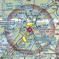
| Sectional chart |
|---|
|
CAUTION: Diagram may not be current

| Airport distance calculator |
|---|
|
|
| Sunrise and sunset |
|---|
|
Times for 25-Mar-2026
| | Local
(UTC-4) | | Zulu
(UTC) |
|---|
| Morning civil twilight | | 07:08 | | 11:08 |
| Sunrise | | 07:33 | | 11:33 |
| Sunset | | 19:50 | | 23:50 |
| Evening civil twilight | | 20:15 | | 00:15 |
|
| Current date and time |
|---|
| Zulu (UTC) | 25-Mar-2026 04:19:03 |
|---|
| Local (UTC-4) | 25-Mar-2026 00:19:03 |
|---|
|
| METAR |
|---|
| KGVL | 250353Z AUTO 09007KT 9SM CLR 12/M01 A3032 RMK AO2 SLP262 T01171011
|
KJCA
15nm SE | 250355Z AUTO 13007KT 10SM CLR 11/02 A3032 RMK AO2 T01140019
|
KLZU
19nm S | 250356Z AUTO 10007KT CLR 12/03 A3029 RMK AO2 SLP268 T01220028 PWINO $
|
KWDR
19nm SE | 250355Z 10SM CLR 11/02 A3033 RMK AO2
|
KAJR
19nm NE | 250355Z AUTO 06007KT 7SM CLR 11/M01 A3032 RMK AO2 T01101010
|
|
| TAF |
|---|
KAHN
31nm SE | 241733Z 2418/2518 10010G20KT P6SM FEW060 SCT250 FM242300 11012KT P6SM SCT100 FM250400 10007KT P6SM BKN150 BKN250 FM251500 11006KT P6SM SCT020 BKN050
|
KPDK
33nm SW | 241733Z 2418/2518 09010G20KT P6SM FEW060 SCT250 FM242300 11012KT P6SM SCT100 FM250400 10007KT P6SM BKN150 BKN250 FM251500 11006KT P6SM SCT020 BKN050
|
|
| NOTAMs |
|---|
NOTAMs are issued by the DoD/FAA and will open in a separate window not controlled by AirNav.
|
|


