FAA INFORMATION EFFECTIVE 19 MARCH 2026
Location
| FAA Identifier: | HIG |
| Lat/Long: | 39-04-20.8000N 093-40-38.5000W
39-04.346667N 093-40.641667W
39.0724444,-93.6773611
(estimated) |
| Elevation: | 840 ft. / 256.0 m (surveyed) |
| Variation: | 02E (2005) |
| From city: | 2 miles E of HIGGINSVILLE, MO |
| Time zone: | UTC -5 (UTC -6 during Standard Time) |
| Zip code: | 64037 |
Airport Operations
| Airport use: | Open to the public |
| Control tower: | no |
| ARTCC: | KANSAS CITY CENTER |
| FSS: | COLUMBIA FLIGHT SERVICE STATION |
| NOTAMs facility: | COU (NOTAM-D service available) |
| Attendance: | SEP-APR 0800-1700, MAY-AUG 0700-1900 |
| Wind indicator: | lighted |
| Segmented circle: | no |
| Lights: | ACTVT MIRL RY 16/34; PAPI & REIL RYS 16 & 34 - CTAF. |
| Beacon: | white-green (lighted land airport)
Operates sunset to sunrise. |
Airport Communications
| CTAF/UNICOM: | 122.8 |
| WHITEMAN APPROACH: | 127.45 |
| WHITEMAN DEPARTURE: | 125.925 |
| WX AWOS-3PT at RCM (18 nm S): | 119.575 (660-422-7010) |
- APCH/DEP SVC PRVDD BY KANSAS CITY ARTCC ON FREQS 135.575/323.15 (KNOB NOSTER RCAG) WHEN WHITEMAN APCH CTL CLSD.
Nearby radio navigation aids
| VOR radial/distance | | VOR name | | Freq | | Var |
|---|
| ANXr087/21.1 | | NAPOLEON VORTAC | | 115.15 | | 07E |
| BQSr162/34.7 | | BRAYMER VOR/DME | | 115.35 | | 03E |
Airport Services
| Fuel available: | 100LL
100LL:FOR SVC AFT HRS, CALL NBRS POSTED ON TERMINAL DOOR. |
| Parking: | hangars and tiedowns |
| Airframe service: | NONE |
| Powerplant service: | NONE |
| Bottled oxygen: | NONE |
| Bulk oxygen: | NONE |
Runway Information
Runway 16/34
| Dimensions: | 4400 x 75 ft. / 1341 x 23 m |
| Surface: | asphalt, in good condition |
| Weight bearing capacity: | | Single wheel: | 12.5 | | Double wheel: | 16.0 |
|
| Runway edge lights: | medium intensity |
| RUNWAY 16 | | RUNWAY 34 |
| Latitude: | 39-04.698333N | | 39-03.996667N |
| Longitude: | 093-40.758333W | | 093-40.525000W |
| Elevation: | 840.0 ft. | | 796.0 ft. |
| Traffic pattern: | left | | left |
| Runway heading: | 163 magnetic, 165 true | | 343 magnetic, 345 true |
| Declared distances: | TORA:4400 TODA:4400 ASDA:4400 LDA:4400 | | TORA:4400 TODA:4400 ASDA:4400 LDA:4400 |
| Markings: | nonprecision, in good condition | | nonprecision, in good condition |
| Visual slope indicator: | 4-light PAPI on left (3.00 degrees glide path) | | 4-light PAPI on left (3.00 degrees glide path) |
| Runway end identifier lights: | yes | | yes |
| Touchdown point: | yes, no lights | | yes, no lights |
| Obstructions: | none | | 27 ft. tree, 750 ft. from runway, 320 ft. right of centerline, 20:1 slope to clear |
Airport Ownership and Management from official FAA records
| Ownership: | Publicly-owned |
| Owner: | CITY OF HIGGINSVILLE
1922 MAIN ST BOX 110
HIGGINSVILLE, MO 64037
Phone 660-584-2106 |
| Manager: | SCOTT MCCORMICK
11667 AIRPORT ROAD
HIGGINSVILLE, MO 64037
Phone 618-420-9046 |
Additional Remarks
| - | WILDLIFE ON & INVOF ARPT. |
| - | EXTENSIVE HELICOPTER OPERATIONS. |
| - | FOR CD CTC WHITEMAN APCH AT 660-687-3132. WHEN WHITEMAN APCH IS CLSD, CTC KANSAS CITY ARTCC AT 913-254-8508. |
Instrument Procedures
NOTE: All procedures below are presented as PDF files. If you need a reader for these files, you should download the free Adobe Reader.NOT FOR NAVIGATION. Please procure official charts for flight.
FAA instrument procedures published for use from 19 March 2026 at 0901Z to 16 April 2026 at 0900Z.
IAPs - Instrument Approach Procedures |
|---|
| RNAV (GPS) RWY 16 | |
download (234KB) |
| RNAV (GPS) RWY 34 | |
download (221KB) |
| NOTE: Special Take-Off Minimums/Departure Procedures apply | |
download (158KB) |
Other nearby airports with instrument procedures:
KRCM - Skyhaven Airport (18 nm S)
KSZL - Whiteman Air Force Base (21 nm S)
KMHL - Marshall Memorial Municipal Airport (22 nm E)
3GV - East Kansas City Airport (25 nm W)
3EX - Excelsior Springs Memorial Airport (29 nm NW)
|
|

Road maps at:
MapQuest
Bing
Google
| Aerial photo |
|---|
WARNING: Photo may not be current or correct

Do you have a better or more recent aerial photo of Higginsville Industrial Municipal Airport that you would like to share? If so, please send us your photo.
|
| Sectional chart |
|---|
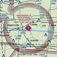
|
| Airport distance calculator |
|---|
|
|
| Sunrise and sunset |
|---|
|
Times for 15-Apr-2026
| | Local
(UTC-5) | | Zulu
(UTC) |
|---|
| Morning civil twilight | | 06:11 | | 11:11 |
| Sunrise | | 06:39 | | 11:39 |
| Sunset | | 19:51 | | 00:51 |
| Evening civil twilight | | 20:18 | | 01:18 |
|
| Current date and time |
|---|
| Zulu (UTC) | 15-Apr-2026 05:20:09 |
|---|
| Local (UTC-5) | 15-Apr-2026 00:20:09 |
|---|
|
| METAR |
|---|
KRCM
18nm S | 150455Z AUTO 18012G18KT 10SM SCT120 22/17 A2977 RMK AO2
|
KMHL
22nm E | 150455Z AUTO 19014G22KT 10SM CLR 22/18 A2977 RMK AO2
|
KSZL
22nm S | 150355Z AUTO 19020G30KT 10SM CLR 23/19 A2978 RMK AO2 PK WND 19040/26 LTG DSNT SW SLP080 P0000 T02320185 VISNO RWY01 CHINO RWY01 $
|
KDMO
32nm SE | 150453Z AUTO 10SM CLR 23/18 A2980 RMK AO2 PK WND 20033/0408 SLP080 T02280178
|
KLXT
33nm W | 150453Z AUTO 20016G25KT 10SM CLR 22/19 A2975 RMK AO2 PK WND 20027/0415 SLP064 T02220189 $
|
KGPH
33nm NW | 150455Z AUTO 20014G23KT 10SM SCT028 23/18 A2972 RMK AO2
|
|
| NOTAMs |
|---|
NOTAMs are issued by the DoD/FAA and will open in a separate window not controlled by AirNav.
|
|

