FAA INFORMATION EFFECTIVE 27 NOVEMBER 2025
Location
| FAA Identifier: | MCZ |
| Lat/Long: | 35-51-43.8940N 077-10-41.5220W
35-51.731567N 077-10.692033W
35.8621928,-77.1782006
(estimated) |
| Elevation: | 74.9 ft. / 22.8 m (surveyed) |
| Variation: | 09W (1990) |
| From city: | 6 miles W of WILLIAMSTON, NC |
| Time zone: | UTC -5 (UTC -4 during Daylight Saving Time) |
| Zip code: | 27892 |
Airport Operations
| Airport use: | Open to the public |
| Control tower: | no |
| ARTCC: | WASHINGTON CENTER |
| FSS: | RALEIGH FLIGHT SERVICE STATION |
| NOTAMs facility: | RDU (NOTAM-D service available) |
| Attendance: | 0800-1700
FOR SVC AFT HRS CALL 252-799-8718 OR 252-217-4023. |
| Wind indicator: | lighted |
| Segmented circle: | yes |
| Lights: | PAPI RWY 03 & 21 OPR CONSLY. MIRL RWY 03/21 DUSK TO DAWN; TO CHG INTST - CTAF. |
| Beacon: | white-green (lighted land airport)
Operates sunset to sunrise. |
Airport Communications
| CTAF/UNICOM: | 122.8 |
| WX AWOS-3P: | 118.65 (252-802-4261) |
| WX AWOS-3 at PGV (17 nm SW): | 128.425 (252-758-6485) |
| WX AWOS-3P at ETC (18 nm W): | 119.575 (252-641-1640) |
| WX AWOS-3 at OCW (19 nm S): | 120.175 (252-975-6133) |
- APCH/DEP SVC PRVDD BY WASHINGTON ARTCC (ZDC) ON 123.85/279.65 (NEW BERN RCAG).
Nearby radio navigation aids
| VOR radial/distance | | VOR name | | Freq | | Var |
|---|
| TYIr110/26.4 | | TAR RIVER VORTAC | | 117.80 | | 05W |
| CVIr215/34.1 | | COFIELD VORTAC | | 114.60 | | 09W |
| ISOr037/34.8 | | KINSTON VORTAC | | 117.50 | | 05W |
| NDB name | | Hdg/Dist | | Freq | | Var | | ID |
|---|
| ALWOOD | | 054/13.3 | | 230 | | 09W | | AQE | .- --.- . |
| CHOCOWINITY | | 359/21.4 | | 388 | | 08W | | RNW | .-. -. .-- |
Airport Services
| Fuel available: | 100LL JET-A1
100LL:100LL AND JET-A HAS 24 HR SELF-SVC WITH CREDIT CARD. |
| Parking: | hangars and tiedowns |
| Airframe service: | NONE |
| Powerplant service: | NONE |
| Bottled oxygen: | NONE |
| Bulk oxygen: | NONE |
Runway Information
Runway 3/21
| Dimensions: | 5000 x 75 ft. / 1524 x 23 m |
| Surface: | asphalt, in good condition |
| Weight bearing capacity: | |
| Runway edge lights: | medium intensity |
| RUNWAY 3 | | RUNWAY 21 |
| Latitude: | 35-51.354407N | | 35-52.108735N |
| Longitude: | 077-10.895797W | | 077-10.488245W |
| Elevation: | 64.7 ft. | | 74.3 ft. |
| Traffic pattern: | left | | left |
| Runway heading: | 033 magnetic, 024 true | | 213 magnetic, 204 true |
| Markings: | nonprecision, in good condition | | nonprecision, in good condition |
| Visual slope indicator: | 2-light PAPI on left (3.00 degrees glide path)
OTS INDEF. | | 2-light PAPI on left (3.00 degrees glide path) |
| Touchdown point: | yes, no lights | | yes, no lights |
| Obstructions: | 16 ft. road, 416 ft. from runway, 259 ft. right of centerline, 13:1 slope to clear
APCH SLOPE 23:1 AT DSPLCD. | | 15 ft. road, 587 ft. from runway, 242 ft. left of centerline, 25:1 slope to clear |
Airport Ownership and Management from official FAA records
| Ownership: | Publicly-owned |
| Owner: | COUNTY OF MARTIN
305 E. MAIN STREET, PO BOX 668
WILLIAMSTON, NC 27892
Phone 252-789-4300 |
| Manager: | JESSE COUNCIL, JULIET CHARLIE AVIAT
2135 AIRPORT RD
WILLIAMSTON, NC 27892
Phone 252-792-1971 |
Additional Remarks
| - | DEER ON AND INVOF ARPT. |
| - | FOR CD CTC WASHINGTON ARTCC AT 703-771-3587. |
| - | RWY 03 HAS 10-15 FT DROP-OFF 70 FT FM CNTRLN BOTH SIDES. |
| - | RWY 03 HAS A MKD DSPLCD THR OF 45 FT (UNPUBLD). |
Instrument Procedures
NOTE: All procedures below are presented as PDF files. If you need a reader for these files, you should download the free Adobe Reader.NOT FOR NAVIGATION. Please procure official charts for flight.
FAA instrument procedures published for use from 27 November 2025 at 0901Z to 25 December 2025 at 0900Z.
IAPs - Instrument Approach Procedures |
|---|
| RNAV (GPS) RWY 03 | |
download (200KB) |
| RNAV (GPS) RWY 21 | |
download (206KB) |
| NOTE: Special Alternate Minimums apply | |
download (167KB) |
| NOTE: Special Take-Off Minimums/Departure Procedures apply | |
download (391KB) |
Other nearby airports with instrument procedures:
KPGV - Pitt-Greenville Airport (17 nm SW)
KETC - Tarboro-Edgecombe Airport (18 nm W)
KOCW - Washington-Warren Airport (19 nm S)
KPMZ - Plymouth Municipal Airport (21 nm E)
KASJ - Tri-County Airport at Henry Joyner Field (26 nm N)
|
|

Road maps at:
MapQuest
Bing
Google
| Aerial photo |
|---|
WARNING: Photo may not be current or correct
 Photo by David Newcomer
Photo taken 14-Mar-2012
from 5,500' altitude looking north.
Photo by David Newcomer
Photo taken 14-Mar-2012
from 5,500' altitude looking north.
Do you have a better or more recent aerial photo of Martin County Airport that you would like to share? If so, please send us your photo.
|
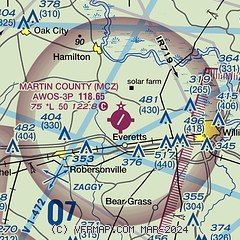
| Sectional chart |
|---|
|
| Airport distance calculator |
|---|
|
|
| Sunrise and sunset |
|---|
|
Times for 23-Dec-2025
| | Local
(UTC-5) | | Zulu
(UTC) |
|---|
| Morning civil twilight | | 06:49 | | 11:49 |
| Sunrise | | 07:17 | | 12:17 |
| Sunset | | 16:58 | | 21:58 |
| Evening civil twilight | | 17:27 | | 22:27 |
|
| Current date and time |
|---|
| Zulu (UTC) | 23-Dec-2025 16:24:57 |
|---|
| Local (UTC-5) | 23-Dec-2025 11:24:57 |
|---|
|
| METAR |
|---|
| KMCZ | 231555Z AUTO 20006KT 10SM BKN050 OVC065 07/05 A3028 RMK AO2 T00740045
|
KPGV
18nm SW | 231555Z AUTO 24006KT 10SM BKN041 OVC050 08/03 A3028 RMK AO2
|
KETC
18nm W | 231555Z AUTO 22007KT 10SM SCT050 BKN075 OVC085 09/03 A3027 RMK AO2 T00900033
|
KOCW
19nm S | 231550Z AUTO 21004KT 10SM BKN044 OVC055 07/03 A3029 RMK AO2 T00720025
|
|
| TAF |
|---|
KPGV
18nm SW | 231120Z 2312/2412 VRB03KT P6SM -DZ BKN200 FM231500 25006KT P6SM BKN040 WS020/23035KT FM231700 24011G19KT P6SM FEW030 OVC040 WS020/25035KT FM232100 25006KT P6SM FEW150 WS020/27035KT FM240200 24006KT P6SM SKC AMD LTD TO CLD VIS AND WIND
|
|
| NOTAMs |
|---|
NOTAMs are issued by the DoD/FAA and will open in a separate window not controlled by AirNav.
|
|


