FAA INFORMATION EFFECTIVE 14 MAY 2026
Location
| FAA Identifier: | ASJ |
| Lat/Long: | 36-17-51.0950N 077-10-15.0700W
36-17.851583N 077-10.251167W
36.2975264,-77.1708528
(estimated) |
| Elevation: | 66.6 ft. / 20.3 m (surveyed) |
| Variation: | 10W (2000) |
| From city: | 9 miles W of AHOSKIE, NC |
| Time zone: | UTC -4 (UTC -5 during Standard Time) |
| Zip code: | 27897 |
Airport Operations
| Airport use: | Open to the public |
| Control tower: | no |
| ARTCC: | WASHINGTON CENTER |
| FSS: | RALEIGH FLIGHT SERVICE STATION |
| NOTAMs facility: | ASJ (NOTAM-D service available) |
| Attendance: | MON-SAT 0900-DUSK, ALL SUN UNATNDD |
| Wind indicator: | lighted |
| Segmented circle: | yes |
| Lights: | ACTVT REIL RWY 01 & 19; MIRL RWY 01/19 - CTAF. PAPI RWY 01 & 19 OPER CONSLY. |
| Beacon: | white-green (lighted land airport)
Operates sunset to sunrise. |
Airport Communications
| CTAF/UNICOM: | 122.8 |
| WX AWOS-3: | 119.075 (252-345-2967) |
- APCH/DEP SVC PRVDD BY WASHINGTON ARTCC (ZDC) ON 123.85/279.65 (NEW BERN RCAG).
Nearby radio navigation aids
| VOR radial/distance | | VOR name | | Freq | | Var |
|---|
| TYIr058/32.2 | | TAR RIVER VORTAC | | 117.80 | | 05W |
| NDB name | | Hdg/Dist | | Freq | | Var | | ID |
|---|
| ALWOOD | | 024/36.8 | | 230 | | 09W | | AQE | .- --.- . |
Airport Services
| Fuel available: | 100LL JET-A1+
100LL:100LL AND JET A - 24 HR SELF SERVICE AVBL WITH CREDIT CARD. |
| Parking: | tiedowns |
| Airframe service: | NONE |
| Powerplant service: | NONE |
| Bottled oxygen: | NONE |
| Bulk oxygen: | NONE |
Runway Information
Runway 1/19
| Dimensions: | 4501 x 75 ft. / 1372 x 23 m |
| Surface: | asphalt, in good condition |
| Weight bearing capacity: | | Single wheel: | 35.0 | | Double wheel: | 45.0 |
|
| Runway edge lights: | medium intensity |
| RUNWAY 1 | | RUNWAY 19 |
| Latitude: | 36-17.480788N | | 36-18.222383N |
| Longitude: | 077-10.238760W | | 077-10.263587W |
| Elevation: | 66.5 ft. | | 66.3 ft. |
| Traffic pattern: | left | | left |
| Runway heading: | 008 magnetic, 358 true | | 188 magnetic, 178 true |
| Markings: | nonprecision, in good condition | | nonprecision, in good condition |
| Visual slope indicator: | 2-light PAPI on left (3.17 degrees glide path) | | 2-light PAPI on left (3.00 degrees glide path) |
| Runway end identifier lights: | yes | | yes |
| Touchdown point: | yes, no lights | | yes, no lights |
| Obstructions: | 10 ft. road, 422 ft. from runway, 22:1 slope to clear | | 71 ft. trees, 973 ft. from runway, 292 ft. left of centerline, 10:1 slope to clear |
Airport Ownership and Management from official FAA records
| Ownership: | Publicly-owned |
| Owner: | TRI-COUNTY AIRPORT AUTH.
140 TRI-COUNTY AIRPORT RD
AULANDER, NC 27805
Phone 252-345-9962 |
| Manager: | HENRY JOYNER
140 TRI-COUNTY AIRPORT RD
AULANDER, NC 27805
Phone 252-345-0111
FOR ARPT AMGR AFTER HOURS CALL 252-395-0822. |
Additional Remarks
| - | RWY 01/19 -4 FT DITCH 120 FT L & R OF CNTRLN. |
| - | FOR CD CTC WASHINGTON ARTCC AT 703-771-3587. |
Instrument Procedures
NOTE: All procedures below are presented as PDF files. If you need a reader for these files, you should download the free Adobe Reader.NOT FOR NAVIGATION. Please procure official charts for flight.
FAA instrument procedures published for use from 14 May 2026 at 0901Z to 11 June 2026 at 0900z.
IAPs - Instrument Approach Procedures |
|---|
| RNAV (GPS) RWY 01 | |
download (234KB) |
| RNAV (GPS) RWY 19 | |
download (231KB) |
| NOTE: Special Alternate Minimums apply | |
download (166KB) |
| NOTE: Special Take-Off Minimums/Departure Procedures apply | |
download (364KB) |
Other nearby airports with instrument procedures:
KIXA - Halifax/Northampton Regional Airport (23 nm W)
KMCZ - Martin County Airport (26 nm S)
KFKN - Franklin Regional Airport (27 nm NE)
KEMV - Emporia-Greensville Regional Airport (28 nm NW)
KETC - Tarboro-Edgecombe Airport (28 nm SW)
|
|

Road maps at:
MapQuest
Bing
Google
| Aerial photo |
|---|
WARNING: Photo may not be current or correct
 Photo by Amy White
Taken in February 2014
looking southeast.
Photo by Amy White
Taken in February 2014
looking southeast.
Do you have a better or more recent aerial photo of Tri-County Airport at Henry Joyner Field that you would like to share? If so, please send us your photo.
|
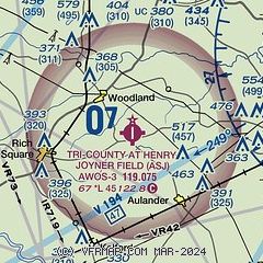
| Sectional chart |
|---|
|
| Airport distance calculator |
|---|
|
|
| Sunrise and sunset |
|---|
|
Times for 15-May-2026
| | Local
(UTC-4) | | Zulu
(UTC) |
|---|
| Morning civil twilight | | 05:35 | | 09:35 |
| Sunrise | | 06:03 | | 10:03 |
| Sunset | | 20:07 | | 00:07 |
| Evening civil twilight | | 20:36 | | 00:36 |
|
| Current date and time |
|---|
| Zulu (UTC) | 15-May-2026 07:22:30 |
|---|
| Local (UTC-4) | 15-May-2026 03:22:30 |
|---|
|
| METAR |
|---|
| KASJ | 150655Z AUTO 00000KT 10SM CLR 09/04 A2997 RMK AO2 T00850040
|
|
| TAF |
|---|
KPGV
42nm S | 150520Z 1506/1606 30005KT P6SM SKC FM151400 31009G17KT P6SM SKC FM152300 00000KT P6SM SKC AMD LTD TO CLD VIS AND WIND
|
KRWI
44nm SW | 150520Z 1506/1606 30006KT P6SM SKC
|
KECG
48nm E | 150520Z 1506/1606 30006KT P6SM FEW080 FM151400 30012G20KT P6SM FEW050 FM152300 10003KT P6SM SKC
|
|
| NOTAMs |
|---|
NOTAMs are issued by the DoD/FAA and will open in a separate window not controlled by AirNav.
|
|

