FAA INFORMATION EFFECTIVE 27 NOVEMBER 2025
Location
| FAA Identifier: | OKZ |
| Lat/Long: | 32-57-58.9490N 082-50-14.9590W
32-57.982483N 082-50.249317W
32.9663747,-82.8374886
(estimated) |
| Elevation: | 438.5 ft. / 133.7 m (surveyed) |
| Variation: | 05W (2005) |
| From city: | 2 miles SW of SANDERSVILLE, GA |
| Time zone: | UTC -5 (UTC -4 during Daylight Saving Time) |
| Zip code: | 31082 |
Airport Operations
| Airport use: | Open to the public |
| Control tower: | no |
| ARTCC: | ATLANTA CENTER |
| FSS: | MACON FLIGHT SERVICE STATION |
| NOTAMs facility: | MCN (NOTAM-D service available) |
| Attendance: | MON-FRI 0800-1700 |
| Wind indicator: | lighted |
| Segmented circle: | yes |
| Lights: | REIL RWY 13; MIRL RWY 13/31 PRESET LOW INTST DUSK-2200; TO INCR INTST & ACTVT AFT 2200 - CTAF. ACTVT PAPI RWYS 13 & 31 - CTAF. |
| Beacon: | white-green (lighted land airport)
Operates sunset to sunrise. |
Airport Communications
| CTAF/UNICOM: | 123.0 |
| WX AWOS-3: | 120.575 (478-240-9432) |
| ATLANTA APPROACH: | 124.2 |
| ATLANTA DEPARTURE: | 124.2 |
- ATLANTA LARGE TRACON PROVIDES APCH/DEP SVC 0615-2300 ON FREQ 124.2; ATLANTA ARTCC PROVIDES APCH/DEP SVC 2300-0615 ON FREQS 123.95/269.3 (MACON RCAG).
Nearby radio navigation aids
| VOR radial/distance | | VOR name | | Freq | | Var |
|---|
| DBNr004/24.2 | | DUBLIN VORTAC | | 113.10 | | 05W |
| NDB name | | Hdg/Dist | | Freq | | Var | | ID |
|---|
| CULVR | | 128/19.7 | | 380 | | 04W | | UMB | ..- -- -... |
Airport Services
| Fuel available: | 100LL JET-A+ |
| Parking: | tiedowns |
| Airframe service: | MAJOR |
| Powerplant service: | MAJOR |
| Bottled oxygen: | NONE |
| Bulk oxygen: | NONE |
Runway Information
Runway 13/31
| Dimensions: | 5501 x 75 ft. / 1677 x 23 m |
| Surface: | asphalt, in good condition |
| Weight bearing capacity: | |
| Runway edge lights: | medium intensity |
| RUNWAY 13 | | RUNWAY 31 |
| Latitude: | 32-58.212297N | | 32-57.752638N |
| Longitude: | 082-50.713138W | | 082-49.785547W |
| Elevation: | 407.1 ft. | | 435.2 ft. |
| Traffic pattern: | left | | left |
| Runway heading: | 125 magnetic, 120 true | | 305 magnetic, 300 true |
| Displaced threshold: | no | | 486 ft. |
| Declared distances: | TORA:5501 TODA:5501 ASDA:5501 LDA:5501 | | TORA:5501 TODA:5501 ASDA:5501 LDA:5015 |
| Markings: | nonprecision, in good condition | | nonprecision, in good condition |
| Visual slope indicator: | 2-light PAPI on left (3.00 degrees glide path) | | 2-light PAPI on left (3.60 degrees glide path) |
| Runway end identifier lights: | yes | | no |
| Touchdown point: | yes, no lights | | yes, no lights |
| Obstructions: | 21 ft. trees, 450 ft. from runway, 276 ft. left of centerline, 11:1 slope to clear | | 60 ft. pole, 1099 ft. from runway, 382 ft. right of centerline, 14:1 slope to clear |
Airport Ownership and Management from official FAA records
| Ownership: | Publicly-owned |
| Owner: | WASHINGTON CO
PO BOX 271
SANDERSVILLE, GA 31082
Phone 478-552-9136
AND CITY OF SANDERSVILLE |
| Manager: | RAY LAWRENCE
1726 KAOLIN RD
SANDERSVILLE, GA 31082
Phone 478-552-9136 |
Additional Remarks
| - | DEER ON & INVOF RYS & TWYS. |
| - | FOR CD CTC ATLANTA APCH AT 678-364-6132, WHEN APCH CLSD CTC ATLANTA ARTCC AT 770-210-7692. |
Instrument Procedures
NOTE: All procedures below are presented as PDF files. If you need a reader for these files, you should download the free Adobe Reader.NOT FOR NAVIGATION. Please procure official charts for flight.
FAA instrument procedures published for use from 27 November 2025 at 0901Z to 25 December 2025 at 0900Z.
IAPs - Instrument Approach Procedures |
|---|
| RNAV (GPS) RWY 13 | |
download (201KB) |
| RNAV (GPS) RWY 31 | |
download (217KB) |
| NOTE: Special Alternate Minimums apply | |
download (157KB) |
| NOTE: Special Take-Off Minimums/Departure Procedures apply | |
download (490KB) |
Other nearby airports with instrument procedures:
2J3 - Louisville Municipal Airport (23 nm E)
KMLJ - Baldwin County Regional Airport (23 nm NW)
KDBN - W H 'Bud' Barron Airport (25 nm S)
KSBO - East Georgia Regional Airport (32 nm SE)
KHQU - Thomson/McDuffie County Airport (37 nm NE)
|
|

Road maps at:
MapQuest
Bing
Google
| Aerial photo |
|---|
WARNING: Photo may not be current or correct
 Photo taken 11-Sep-2015
looking northwest.
Photo taken 11-Sep-2015
looking northwest.
Do you have a better or more recent aerial photo of Kaolin Field Airport that you would like to share? If so, please send us your photo.
|
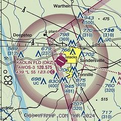
| Sectional chart |
|---|
|
| Airport distance calculator |
|---|
|
|
| Sunrise and sunset |
|---|
|
Times for 01-Dec-2025
| | Local
(UTC-5) | | Zulu
(UTC) |
|---|
| Morning civil twilight | | 06:50 | | 11:50 |
| Sunrise | | 07:17 | | 12:17 |
| Sunset | | 17:24 | | 22:24 |
| Evening civil twilight | | 17:51 | | 22:51 |
|
| Current date and time |
|---|
| Zulu (UTC) | 01-Dec-2025 05:10:11 |
|---|
| Local (UTC-5) | 01-Dec-2025 00:10:11 |
|---|
|
| TAF |
|---|
KWRB
43nm SW | 301600Z 3016/0119 06006KT 9999 SCT015 OVC030 QNH3024INS BECMG 3014/3015 04003KT 9999 VCSH SCT015 OVC030 QNH3027INS TEMPO 3018/3021 03009KT 8000 -SHRA BKN025 BECMG 3022/3023 01003KT 9999 VCSH SCT025 OVC040 QNH3019INS BECMG 0104/0105 01006KT 8000 BR SCT007 OVC010 QNH3024INS BECMG 0111/0112 04006KT 9999 NSW BKN020 QNH3026INS BECMG 0116/0117 06006KT 9999 VCSH BKN020 QNH3026INS TX14/3020Z TN08/3013Z LAST NO AMDS AFT 3016 NEXT 0111
|
KMCN
44nm W | 301750Z 3018/0118 VRB04KT P6SM BKN050 FM302300 36004KT 6SM -DZ BR BKN030 FM010400 36004KT 6SM BR BKN015 OVC030 FM011400 06006KT P6SM BKN015 OVC030
|
KAGS
50nm NE | 301720Z 3018/0118 VRB03KT P6SM SCT070 FM302000 33005KT P6SM SCT025 BKN070 PROB30 3021/0103 5SM -RA BR OVC025 FM010900 05007KT P6SM SCT025 OVC040
|
|
| NOTAMs |
|---|
NOTAMs are issued by the DoD/FAA and will open in a separate window not controlled by AirNav.
|
|


