FAA INFORMATION EFFECTIVE 14 MAY 2026
Location
| FAA Identifier: | ORS |
| Lat/Long: | 48-42-30.0140N 122-54-38.1430W
48-42.500233N 122-54.635717W
48.7083372,-122.9105953
(estimated) |
| Elevation: | 34.8 ft. / 10.6 m (surveyed) |
| Variation: | 17E (2010) |
| From city: | 1 mile N of EASTSOUND, WA |
| Time zone: | UTC -7 (UTC -8 during Standard Time) |
| Zip code: | 98245 |
Airport Operations
| Airport use: | Open to the public |
| Activation date: | 11/1945 |
| Control tower: | no |
| ARTCC: | VANCOUVER CENTER |
| FSS: | SEATTLE FLIGHT SERVICE STATION |
| NOTAMs facility: | ORS (NOTAM-D service available) |
| Attendance: | 0800-1630 |
| Pattern altitude: | 1034.8 ft. MSL |
| Wind indicator: | lighted |
| Segmented circle: | yes |
| Lights: | ACTVT REIL RWY 16 & 34; PAPI RWY 16; MIRL RWY 16/34; TWY LGTS - CTAF. REIL RWY 16 & 34 PHOTOCELL NOT AVBL DALGT. |
| Beacon: | white-green (lighted land airport)
Operates sunset to sunrise. |
Airport Communications
| CTAF: | 128.25 |
| WX AWOS-3P: | 135.425 (360-376-6045) |
| WHIDBEY APPROACH: | 118.2 132.7 |
| WHIDBEY DEPARTURE: | 118.2 132.7 |
| WX ASOS at FHR (12 nm S): | 135.675 (360-378-8491) |
| WX AWOS-3P at S31 (14 nm S): | 118.525 (360-376-2071) |
| WX ASOS at BLI (16 nm E): | PHONE 360-671-8688 |
- APCH/DEP SVC PRVDD BY ATCT NUW (WHIDBEY ISLAND NAS /AULT FIELD/ OAK HARBOR, WA) ON FREQS 118.2/285.65 FOR ACFT ARR AND DEP TO THE SOUTH.
- APCH/DEP SVC PRVDD BY VICTORIA TRML (YYJ) ON FREQ 132.7 FOR ACFT ARR AND DEP TO THE NORTH.
Nearby radio navigation aids
| VOR radial/distance | | VOR name | | Freq | | Var |
|---|
| YYJr076/22.7 | | VICTORIA VOR/DME | | 113.70 | | 17E |
| YVRr140/24.1 | | VANCOUVER VOR/DME | | 115.90 | | 17E |
| CVVr326/28.8 | | PENN COVE VOR/DME | | 117.20 | | 19E |
| NDB name | | Hdg/Dist | | Freq | | Var | | ID |
|---|
| FRIDAY HARBOR | | 004/12.6 | | 284 | | 17E | | FHR | ..-. .... .-. |
Airport Services
| Fuel available: | 100LL
100LL:CREDIT CARD SELF SVC H24. |
| Parking: | tiedowns |
Runway Information
Runway 16/34
| Dimensions: | 2901 x 60 ft. / 884 x 18 m |
| Surface: | asphalt/aggregate friction seal coat, in good condition |
| Weight bearing capacity: | |
| Runway edge lights: | medium intensity |
| Runway edge markings: | FADED. |
| Operational restrictions: | RWY 34 CALM WIND RWY. |
| RUNWAY 16 | | RUNWAY 34 |
| Latitude: | 48-42.738730N | | 48-42.261740N |
| Longitude: | 122-54.634478W | | 122-54.636970W |
| Elevation: | 11.2 ft. | | 34.8 ft. |
| Traffic pattern: | left | | right |
| Runway heading: | 163 magnetic, 180 true | | 343 magnetic, 000 true |
| Markings: | nonprecision, in poor condition | | nonprecision, in poor condition |
| Visual slope indicator: | 4-light PAPI on right (3.48 degrees glide path) | | 2-light PAPI on left (4.00 degrees glide path)
PAPI UNSUBL BYD 2 DEGS LEFT OF CNTRLN. |
| Runway end identifier lights: | yes | | yes |
| Touchdown point: | yes, no lights | | yes, no lights |
| Obstructions: | 10 ft. road, 387 ft. from runway, 18:1 slope to clear
3 FT SIGN 126 FT L & 19 FT FM THR; DITCH 100 FT R OF THR. | | 128 ft. trees, 2000 ft. from runway, 267 ft. left of centerline, 14:1 slope to clear |
Airport Ownership and Management from official FAA records
| Ownership: | Publicly-owned |
| Owner: | PORT OF ORCAS
P.O. BOX 53
EASTSOUND, WA 98245
Phone 360-376-5285 |
| Manager: | CHIP LONG
PO BOX 53
EASTSOUND, WA 98245
Phone 360-376-5285 |
Additional Remarks
| - | NOISE ABATEMENT PROCS IN EFCT - AMGR. |
| - | ADNL TSNT TURF TIEDOWNS S OF SEGEMENTED CIRCLE. |
| - | DEER ON & INVOF RWY. |
| - | NGT CIRCLING APCH NA FM W SIDE OF RWY. |
| - | GRASS SFC LNDG NA. |
| - | FOR CD FOR DEP FROM RWY 16/34, CTC VICTORIA TRML AT 604-586-4561. |
Instrument Procedures
NOTE: All procedures below are presented as PDF files. If you need a reader for these files, you should download the free Adobe Reader.NOT FOR NAVIGATION. Please procure official charts for flight.
FAA instrument procedures published for use from 14 May 2026 at 0901Z to 11 June 2026 at 0900Z.
IAPs - Instrument Approach Procedures |
|---|
| RNAV (GPS) RWY 16 | |
download (238KB) |
| RNAV (GPS) RWY 34 | |
download (228KB) |
| RNAV (GPS)-A | |
download (205KB) |
| NOTE: Special Alternate Minimums apply | |
download (211KB) |
Departure Procedures |
|---|
| FEGBA THREE (RNAV) | |
download (126KB) |
|
|---|
| SQURL TWO (OBSTACLE) (RNAV) | |
download (179KB) |
| NOTE: Special Take-Off Minimums/Departure Procedures apply | |
download (548KB) |
Other nearby airports with instrument procedures:
KFHR - Friday Harbor Airport (12 nm S)
KBLI - Bellingham International Airport (16 nm E)
KNUW - Whidbey Island Naval Air Station (Ault Field) Airport (24 nm SE)
KBVS - Skagit Regional Airport (24 nm SE)
KOKH - DeLaurentis Airport (29 nm S)
|
|

Road maps at:
MapQuest
Bing
Google
| Aerial photo |
|---|
WARNING: Photo may not be current or correct
 Photo by Trent Thomas
Photo taken 06-Jan-2023
Facing south at 1,500 AGL
Photo by Trent Thomas
Photo taken 06-Jan-2023
Facing south at 1,500 AGL
Do you have a better or more recent aerial photo of Orcas Island Airport that you would like to share? If so, please send us your photo.
|
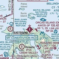
| Sectional chart |
|---|
|
| Airport distance calculator |
|---|
|
|
| Sunrise and sunset |
|---|
|
Times for 26-May-2026
| | Local
(UTC-7) | | Zulu
(UTC) |
|---|
| Morning civil twilight | | 04:39 | | 11:39 |
| Sunrise | | 05:19 | | 12:19 |
| Sunset | | 20:58 | | 03:58 |
| Evening civil twilight | | 21:38 | | 04:38 |
|
| Current date and time |
|---|
| Zulu (UTC) | 26-May-2026 14:46:21 |
|---|
| Local (UTC-7) | 26-May-2026 07:46:21 |
|---|
|
| METAR |
|---|
| KORS | 261435Z AUTO 00000KT 2SM RA BR FEW008 BKN013 OVC023 12/11 A2989 RMK AO2
|
CWEZ
6nm NW | 261000Z AUTO 22002KT 11/10 RMK AO1 SLP101 T01070099 50005
|
KFHR
12nm SW | 261441Z AUTO 00000KT 10SM -RA SCT014 BKN021 OVC038 11/11 A2991 RMK AO2 P0001 T01110106
|
KBLI
16nm E | 261408Z 00000KT 5SM -RA BR BKN007 BKN018 OVC023 11/10 A2988 RMK AO2 P0001 T01110100
|
CWZO
16nm SW | 261400Z AUTO 32007KT RMK AO1
|
CWWK
19nm N | 261400Z AUTO 00000KT 11/10 RMK AO1 6PAST HR 3017 SLP119 P0006 T01130095 50020
|
|
| TAF |
|---|
KBLI
16nm E | 261122Z 2612/2712 VRB04KT P6SM VCSH OVC017 FM262100 22005KT P6SM BKN035 BKN050 FM270300 25004KT P6SM SCT050 SCT120 FM271100 VRB04KT P6SM SCT120 SCT200
|
|
| NOTAMs |
|---|
NOTAMs are issued by the DoD/FAA and will open in a separate window not controlled by AirNav.
|
|

