FAA INFORMATION EFFECTIVE 30 OCTOBER 2025
Location
| FAA Identifier: | SUT |
| Lat/Long: | 33-55-50.9360N 078-04-24.1090W
33-55.848933N 078-04.401817W
33.9308156,-78.0733636
(estimated) |
| Elevation: | 26 ft. / 7.9 m (surveyed) |
| Variation: | 08W (2000) |
| From city: | 1 mile NE of OAK ISLAND, NC |
| Time zone: | UTC -5 (UTC -4 during Daylight Saving Time) |
| Zip code: | 28461 |
Airport Operations
| Airport use: | Open to the public |
| Control tower: | no |
| ARTCC: | WASHINGTON CENTER |
| FSS: | RALEIGH FLIGHT SERVICE STATION |
| NOTAMs facility: | SUT (NOTAM-D service available) |
| Attendance: | 0800-1800
FOR SVC AFTER HRS CALL 910-540-0957. |
| Wind indicator: | lighted |
| Segmented circle: | yes |
| Lights: | ACTVT PAPI RWY 05 & 23; MIRL RWY 05/23 - CTAF. |
| Beacon: | white-green (lighted land airport)
Operates sunset to sunrise. |
Airport Communications
| CTAF/UNICOM: | 123.05 |
| WX AWOS-3P: | 124.175 (910-457-1710) |
| WILMINGTON APPROACH: | 118.25 |
| WILMINGTON DEPARTURE: | 118.25 |
- APCH/DEP SVC PRVDD BY WASHINGTON ARTCC ON FREQS 124.025/269.15 (WILMINGTON RCAG) WHEN WILMINGTON APCH CTL CLSD.
Nearby radio navigation aids
| VOR radial/distance | | VOR name | | Freq | | Var |
|---|
| ILMr208/27.1 | | WILMINGTON VORTAC | | 117.00 | | 07W |
| CREr081/33.2 | | GRAND STRAND VORTAC | | 114.40 | | 03W |
| NDB name | | Hdg/Dist | | Freq | | Var | | ID |
|---|
| CAMP | | 130/37.8 | | 227 | | 07W | | CPC | -.-. .--. -.-. |
Airport Services
| Fuel available: | 100LL JET-A1+
A1+:FUEL AVBL 24 HR SELF SVC WITH CREDIT CARD. |
| Parking: | hangars and tiedowns |
| Airframe service: | MAJOR |
| Powerplant service: | MAJOR |
| Bottled oxygen: | NONE |
| Bulk oxygen: | NONE |
Runway Information
Runway 5/23
| Dimensions: | 5505 x 100 ft. / 1678 x 30 m |
| Surface: | asphalt, in excellent condition |
| Weight bearing capacity: | | Single wheel: | 60.0 | | Double wheel: | 80.0 |
|
| Runway edge lights: | medium intensity |
| RUNWAY 5 | | RUNWAY 23 |
| Latitude: | 33-55.506633N | | 33-56.191217N |
| Longitude: | 078-04.759260W | | 078-04.044338W |
| Elevation: | 18.9 ft. | | 26.0 ft. |
| Traffic pattern: | left | | left |
| Runway heading: | 049 magnetic, 041 true | | 229 magnetic, 221 true |
| Displaced threshold: | no | | 400 ft. |
| Declared distances: | TORA:5505 TODA:5505 ASDA:5505 LDA:5505 | | TORA:5505 TODA:5505 ASDA:5505 LDA:5105 |
| Markings: | nonprecision, in good condition | | nonprecision, in good condition |
| Visual slope indicator: | 2-light PAPI on left (3.00 degrees glide path) | | 2-light PAPI on left (4.00 degrees glide path)
UNUSBL BYD 9 DEG LEFT AND BYD 8 DEG RIGHT OF CNTRLN. |
| Runway end identifier lights: | no | | no |
| Touchdown point: | yes, no lights | | yes, no lights |
| Obstructions: | 33 ft. boat, 1108 ft. from runway, 27:1 slope to clear | | 47 ft. trees, 1388 ft. from runway, 280 ft. right of centerline, 25:1 slope to clear
APCH RATIO 34:1 TO DSPLCD THR DUE TO 46 FT TREES 1782 FT FM DSPLCD THR OFFSET 330 FT RIGHT OF CNTRLN. |
Airport Ownership and Management from official FAA records
| Ownership: | Publicly-owned |
| Owner: | BRUNSWICK CO ARPT COMMISSION
4019 LONG BEACH ROAD
OAK ISLAND, NC 28461
Phone 910-457-6534 |
| Manager: | HOWARD FRANKLIN
4015 AIRPORT ROAD
SOUTHPORT, NC 28465
Phone 910-457-6483 |
Additional Remarks
| - | DEER AND BIRDS ON AND INVOF ARPT. |
| - | 4 FT DITCH 125 FT EACH SIDE RWY 05/23. |
| - | ARPT PHONE 910-457-6483. |
| - | FLT TRNG & SIGHTSEEING OPNS INVOF ARPT. |
| - | SKYDIVING OPNS. |
| - | HEL FLT TRNG AND SIGHTSEEING TOUR OPNS INVOF ARPT. |
| - | FOR CD CTC WILMINGTON APCH AT 910-815-4676, OR WHEN APCH CLSD CTC WASHINGTON ARTCC AT 703-771-3587. |
Instrument Procedures
NOTE: All procedures below are presented as PDF files. If you need a reader for these files, you should download the free Adobe Reader.NOT FOR NAVIGATION. Please procure official charts for flight.
FAA instrument procedures published for use from 30 October 2025 at 0901Z to 27 November 2025 at 0900Z.
IAPs - Instrument Approach Procedures |
|---|
| RNAV (GPS) RWY 05 | |
download (254KB) |
| RNAV (GPS) RWY 23 | |
download (282KB) |
| NOTE: Special Alternate Minimums apply | |
download (26KB) |
| NOTE: Special Take-Off Minimums/Departure Procedures apply | |
download (141KB) |
Other nearby airports with instrument procedures:
KILM - Wilmington International Airport (22 nm N)
KCRE - Grand Strand Airport (33 nm W)
KCPC - Columbus County Regional Airport (38 nm NW)
5J9 - Twin City Airport (40 nm W)
KMYR - Myrtle Beach International Airport (45 nm W)
|
|

Road maps at:
MapQuest
Bing
Google
| Aerial photo |
|---|
WARNING: Photo may not be current or correct
 Photo by Richard Largent
Photo taken 08-Feb-2014
looking north-northeast.
Photo by Richard Largent
Photo taken 08-Feb-2014
looking north-northeast.
Do you have a better or more recent aerial photo of Cape Fear Regional Jetport/Howie Franklin Field Airport that you would like to share? If so, please send us your photo.
|
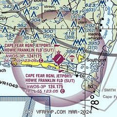
| Sectional chart |
|---|
|
| Airport distance calculator |
|---|
|
|
| Sunrise and sunset |
|---|
|
Times for 22-Nov-2025
| | Local
(UTC-5) | | Zulu
(UTC) |
|---|
| Morning civil twilight | | 06:25 | | 11:25 |
| Sunrise | | 06:52 | | 11:52 |
| Sunset | | 17:05 | | 22:05 |
| Evening civil twilight | | 17:32 | | 22:32 |
|
| Current date and time |
|---|
| Zulu (UTC) | 23-Nov-2025 03:02:46 |
|---|
| Local (UTC-5) | 22-Nov-2025 22:02:46 |
|---|
|
| METAR |
|---|
| KSUT | 230255Z AUTO 24008KT 10SM CLR 18/17 A2995 RMK AO2
|
|
| TAF |
|---|
KILM
22nm NE | 221720Z 2218/2318 27011KT P6SM SCT100 FM222200 26007KT P6SM SCT080 PROB30 2300/2306 6SM -SHRA BR BKN035 FM230800 36005KT P6SM OVC005
|
|
| NOTAMs |
|---|
NOTAMs are issued by the DoD/FAA and will open in a separate window not controlled by AirNav.
|
|


