FAA INFORMATION EFFECTIVE 22 JANUARY 2026
Location
| FAA Identifier: | TAZ |
| Lat/Long: | 39-31-57.3078N 089-19-50.5449W
39-31.955130N 089-19.842415W
39.5325855,-89.3307069
(estimated) |
| Elevation: | 622 ft. / 189.6 m (surveyed) |
| Variation: | 00E (1995) |
| From city: | 2 miles SW of TAYLORVILLE, IL |
| Time zone: | UTC -6 (UTC -5 during Daylight Saving Time) |
| Zip code: | 62568 |
Airport Operations
| Airport use: | Open to the public |
| Activation date: | 03/1947 |
| Control tower: | no |
| ARTCC: | KANSAS CITY CENTER |
| FSS: | SAINT LOUIS FLIGHT SERVICE STATION |
| NOTAMs facility: | TAZ (NOTAM-D service available) |
| Attendance: | MON-FRI 0900-1700 |
| Pattern altitude: | TPA: RWY 09L/27R 600 FT AGL; RWY 09R/27L & RWY 18/36 800 FT AGL. |
| Wind indicator: | lighted |
| Segmented circle: | yes |
| Lights: | ACVT REIL RWY 09R, 18 & 27L; PVASI RWY 09R, 18, 27L & 36; MIRL RWY 09R/27L - CTAF. MIRL RWY 18/36 PRE-SET LOW INTST TO INCR INTST - CTAF. |
| Beacon: | white-green (lighted land airport)
Operates sunset to sunrise. |
Airport Communications
| CTAF/UNICOM: | 122.8 |
| WX AWOS-3PT: | 123.875 (217-824-9323) |
| SAINT LOUIS APPROACH: | 126.15 |
| SAINT LOUIS DEPARTURE: | 126.15 |
Nearby radio navigation aids
| VOR radial/distance | | VOR name | | Freq | | Var |
|---|
| SPIr140/24.4 | | SPINNER VORTAC | | 112.70 | | 01W |
| AXCr238/25.1 | | ADDERS VORTAC | | 117.20 | | 03E |
| NDB name | | Hdg/Dist | | Freq | | Var | | ID |
|---|
| SHELBYVILLE | | 291/23.8 | | 365 | | 02W | | SYZ | ... -.-- --.. |
| ABRAHAM | | 179/37.7 | | 329 | | 00E | | AAA | .- .- .- |
Airport Services
| Fuel available: | 100LL JET-A
100LL:SELF SVC FUEL LCTD ON N RAMP AVBL H24 WITH CREDIT CARD. |
| Parking: | hangars and tiedowns |
| Airframe service: | MAJOR |
| Powerplant service: | MAJOR |
Runway Information
Runway 18/36
| Dimensions: | 4001 x 75 ft. / 1220 x 23 m |
| Surface: | asphalt/porous friction courses, in fair condition |
| Runway edge lights: | medium intensity |
| RUNWAY 18 | | RUNWAY 36 |
| Latitude: | 39-32.270088N | | 39-31.611193N |
| Longitude: | 089-19.650668W | | 089-19.640552W |
| Elevation: | 615.5 ft. | | 620.1 ft. |
| Traffic pattern: | left | | left |
| Runway heading: | 179 | | 359 |
| Markings: | nonprecision, in fair condition | | nonprecision, in fair condition |
| Visual slope indicator: | pulsating/steady burning VASI on left (3.00 degrees glide path)
UNUSBL BYD 6 DEG LEFT & RIGHT OF CNTRLN. OPR ONLY WHEN RWY LGT ARE ACT BY CTAF. | | pulsating/steady burning VASI on left (3.00 degrees glide path)
UNUSBL BYD 5 DEG LEFT & RIGHT OF CNTRLN. |
| Runway end identifier lights: | yes | | |
| Touchdown point: | yes, no lights | | yes, no lights |
Runway 9R/27L
| Dimensions: | 3501 x 60 ft. / 1067 x 18 m |
| Surface: | asphalt, in good condition |
| Runway edge lights: | medium intensity |
| RUNWAY 9R | | RUNWAY 27L |
| Latitude: | 39-31.784353N | | 39-31.791190N |
| Longitude: | 089-20.502157W | | 089-19.757572W |
| Elevation: | 616.2 ft. | | 616.3 ft. |
| Traffic pattern: | right | | left |
| Runway heading: | 090 | | 270 |
| Markings: | basic, in fair condition | | basic, in fair condition |
| Visual slope indicator: | pulsating/steady burning VASI on left (3.00 degrees glide path)
UNUSBL BYD 8 DEG RIGHT OF CNTRLN. | | pulsating/steady burning VASI on left (4.00 degrees glide path)
UNUSBL 6 DEG RIGHT & 8 DEG LEFT OF CNTRLN. |
| Runway end identifier lights: | yes | | yes |
| Touchdown point: | yes, no lights | | yes, no lights |
Runway 9L/27R
| Dimensions: | 1933 x 165 ft. / 589 x 50 m |
| Surface: | turf, in good condition |
| Runway edge markings: | MKD WITH WHITE ROCKS. |
| RUNWAY 9L | | RUNWAY 27R |
| Latitude: | 39-32.289460N | | 39-32.287008N |
| Longitude: | 089-19.934745W | | 089-19.523537W |
| Elevation: | 616.8 ft. | | 612.9 ft. |
| Traffic pattern: | left | | right |
| Runway heading: | 090 | | 270 |
| Displaced threshold: | no | | 286 ft. |
| Markings: | none | | none |
| Runway end identifier lights: | no | | no |
| Touchdown point: | yes, no lights | | yes, no lights |
| Obstructions: | none | | 14 ft. road, 22 ft. from runway, 1:1 slope to clear
APCH RATIO TO DSPLCD THLD 21:1 WHEN CONSIDERING 28 FT BLDG 592 FT 96 FT L OF CNTRLN. |
Airport Ownership and Management from official FAA records
| Ownership: | Publicly-owned |
| Owner: | CITY OF TAYLORVILLE
CITY HALL-115 N. MAIN
TAYLORVILLE, IL 62568
Phone 217-824-2101 |
| Manager: | ANDY GOODALL
1501 S. SPRESSER
TAYLORVILLE, IL 62568
Phone 217-824-9313 |
Additional Remarks
| - | 172 FT LGTD WATER TWR LCT 3007 FT FM RWY 27L END 488 FT L. |
| - | FOR CD CTC ST LOUIS APCH 314-890-1017. |
Instrument Procedures
NOTE: All procedures below are presented as PDF files. If you need a reader for these files, you should download the free Adobe Reader.NOT FOR NAVIGATION. Please procure official charts for flight.
FAA instrument procedures published for use from 22 January 2026 at 0901Z to 19 February 2026 at 0900z.
IAPs - Instrument Approach Procedures |
|---|
| RNAV (GPS) RWY 18 **CHANGED** | |
download (216KB) |
| RNAV (GPS) RWY 36 **CHANGED** | |
download (207KB) |
| NOTE: Special Alternate Minimums apply | |
download (52KB) |
| NOTE: Special Take-Off Minimums/Departure Procedures apply | |
download (485KB) |
Other nearby airports with instrument procedures:
2H0 - Shelby County Airport (24 nm E)
KSPI - Abraham Lincoln Capital Airport (25 nm NW)
3LF - Litchfield Municipal Airport (27 nm SW)
KDEC - Decatur Airport (28 nm NE)
KVLA - Vandalia Municipal Airport (33 nm S)
|
|

Road maps at:
MapQuest
Bing
Google
| Aerial photo |
|---|
WARNING: Photo may not be current or correct
 Photo by Eve Cascella
Photo taken 23-Jun-2008
looking north
Photo by Eve Cascella
Photo taken 23-Jun-2008
looking north
Do you have a better or more recent aerial photo of Taylorville Municipal Airport that you would like to share? If so, please send us your photo.
|
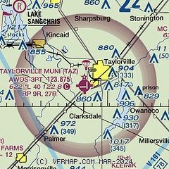
| Sectional chart |
|---|
|
| Airport distance calculator |
|---|
|
|
| Sunrise and sunset |
|---|
|
Times for 06-Feb-2026
| | Local
(UTC-6) | | Zulu
(UTC) |
|---|
| Morning civil twilight | | 06:33 | | 12:33 |
| Sunrise | | 07:01 | | 13:01 |
| Sunset | | 17:22 | | 23:22 |
| Evening civil twilight | | 17:50 | | 23:50 |
|
| Current date and time |
|---|
| Zulu (UTC) | 06-Feb-2026 19:59:14 |
|---|
| Local (UTC-6) | 06-Feb-2026 13:59:14 |
|---|
|
| METAR |
|---|
| KTAZ | 061935Z AUTO 33011KT 10SM OVC024 04/00 A2998 RMK AO2 T00380000
|
|
| TAF |
|---|
KSPI
25nm NW | 061726Z 0618/0718 34016G27KT P6SM BKN020 FM062300 33013G23KT P6SM BKN045 FM070200 34012G21KT P6SM SCT160
|
KDEC
29nm NE | 061726Z 0618/0718 34016G28KT P6SM BKN015 FM070200 34013G21KT P6SM SCT025 FM070400 35012KT P6SM SCT030 BKN120 FM070700 01011KT P6SM FEW150 FM071100 02007KT P6SM SKC
|
|
| NOTAMs |
|---|
NOTAMs are issued by the DoD/FAA and will open in a separate window not controlled by AirNav.
|
|

