FAA INFORMATION EFFECTIVE 12 JUNE 2025
Location
| FAA Identifier: | TCS |
| Lat/Long: | 33-14-07.3000N 107-16-11.6000W
33-14.121667N 107-16.193333W
33.2353611,-107.2698889
(estimated) |
| Elevation: | 4861.9 ft. / 1481.9 m (surveyed) |
| Variation: | 13E (1965) |
| From city: | 6 miles N of TRUTH OR CONSEQUENCES, NM |
| Time zone: | UTC -6 (UTC -7 during Standard Time) |
| Zip code: | 87901 |
Airport Operations
| Airport use: | Open to the public |
| Activation date: | 02/1946 |
| Control tower: | no |
| ARTCC: | ALBUQUERQUE CENTER |
| FSS: | ALBUQUERQUE FLIGHT SERVICE STATION |
| NOTAMs facility: | TCS (NOTAM-D service available) |
| Attendance: | 0800-1600 |
| Wind indicator: | lighted |
| Segmented circle: | no |
| Lights: | DUSK-DAWN: ACTVT MIRL RWY 13/31 - CTAF. |
| Beacon: | white-green (lighted land airport)
Operates sunset to sunrise. |
Airport Communications
| CTAF/UNICOM: | 122.8 |
| WX ASOS: | 120.675 (575-223-0047) |
- APCH/DEP SVC PRVDD BY ALBUQUERQUE ARTCC (ZAB) ON FREQS 128.2/285.5 (TRUTH OR CONSEQUENCES RCAG).
Nearby radio navigation aids
| VOR radial/distance | | VOR name | | Freq | | Var |
|---|
| TCSr156/2.9 | | TRUTH OR CONSEQUENCES VOR | | 112.70 | | 13E |
Airport Services
| Fuel available: | 100LL JET-A1+ |
| Parking: | hangars and tiedowns |
Runway Information
Runway 13/31
| Dimensions: | 7202 x 75 ft. / 2195 x 23 m |
| Surface: | asphalt, in good condition |
| Weight bearing capacity: | | PCN 15 /F/C/X/T | | Single wheel: | 410.0 | | Double wheel: | 595.0 |
|
| Runway edge lights: | medium intensity |
| RUNWAY 13 | | RUNWAY 31 |
| Latitude: | 33-14.593035N | | 33-13.625863N |
| Longitude: | 107-16.623377W | | 107-15.803960W |
| Elevation: | 4852.6 ft. | | 4794.1 ft. |
| Traffic pattern: | left | | left |
| Runway heading: | 132 magnetic, 145 true | | 312 magnetic, 325 true |
| Markings: | nonprecision, in good condition | | nonprecision, in good condition |
| Visual slope indicator: | 2-light PAPI on left (3.00 degrees glide path) | | 2-light PAPI on left (3.00 degrees glide path) |
| Touchdown point: | yes, no lights | | yes, no lights |
Runway 11/29
| Dimensions: | 6981 x 190 ft. / 2128 x 58 m |
| Surface: | gravel, in good condition |
| Operational restrictions: | 2-4 FT BRUSH 100 FT BOTH SIDES E 500 FT. |
| RUNWAY 11 | | RUNWAY 29 |
| Latitude: | 33-14.549362N | | 33-13.882977N |
| Longitude: | 107-16.876310W | | 107-15.759783W |
| Elevation: | 4861.9 ft. | | 4799.3 ft. |
| Traffic pattern: | left | | left |
| Runway heading: | 112 magnetic, 125 true | | 292 magnetic, 305 true |
| Touchdown point: | yes, no lights | | yes, no lights |
| Obstructions: | 8 ft. brush, 2 ft. from runway
CTLG OBSTN EXCEEDS 45 DEG SLOPE. | | 6 ft. brush |
Runway 1/19
| Dimensions: | 3302 x 130 ft. / 1006 x 40 m |
| Surface: | gravel, in good condition
SFC HAS SCATTERED LRG ROCKS. |
| Weight bearing capacity: | | PCN 15 /F/C/X/T | | Single wheel: | 410.0 | | Double wheel: | 595.0 |
|
| Operational restrictions: | 2-4 FT BRUSH 75 FT BOTH SIDES W 1800 FT. |
| RUNWAY 1 | | RUNWAY 19 |
| Latitude: | 33-13.789158N | | 33-14.296670N |
| Longitude: | 107-16.228845W | | 107-15.994695W |
| Elevation: | 4812.5 ft. | | 4818.0 ft. |
| Traffic pattern: | left | | left |
| Runway heading: | 008 magnetic, 021 true | | 188 magnetic, 201 true |
| Touchdown point: | yes, no lights | | yes, no lights |
| Obstructions: | none | | 15 ft. road, 90 ft. from runway, 6:1 slope to clear |
Runway 15/33
| Dimensions: | 3001 x 140 ft. / 915 x 43 m |
| Surface: | gravel, in good condition |
| RUNWAY 15 | | RUNWAY 33 |
| Latitude: | 33-14.304333N | | 33-13.822677N |
| Longitude: | 107-16.052742W | | 107-15.918617W |
| Elevation: | 4821.0 ft. | | 4802.9 ft. |
| Traffic pattern: | left | | left |
| Runway heading: | 154 magnetic, 167 true | | 334 magnetic, 347 true |
| Touchdown point: | yes, no lights | | yes, no lights |
| Obstructions: | 15 ft. road, 45 ft. from runway, 3:1 slope to clear | | none |
Runway 7/25
| Dimensions: | 2933 x 130 ft. / 894 x 40 m |
| Surface: | gravel, in good condition
+1 FT BRUSH & ROUGH AREAS. |
| RUNWAY 7 | | RUNWAY 25 |
| Latitude: | 33-14.021573N | | 33-14.116228N |
| Longitude: | 107-16.439257W | | 107-15.875062W |
| Elevation: | 4828.5 ft. | | 4808.7 ft. |
| Traffic pattern: | left | | left |
| Runway heading: | 066 magnetic, 079 true | | 246 magnetic, 259 true |
| Touchdown point: | yes, no lights | | yes, no lights |
| Obstructions: | none
CTLG OBSTN EXCEEDS 45 DEG SLOPE. | | 10 ft. road |
Airport Ownership and Management from official FAA records
| Ownership: | Publicly-owned |
| Owner: | CITY OF TRUTH OR CONSEQUENCES
505 SIMS
TRUTH OR CONSEQUENCE, NM 87901
Phone 575-894-6673 |
| Manager: | CHAD ROSACKER
505 SIMS
TRUTH OR CONSEQUENCE, NM 87901
Phone 575-894-6199 |
Additional Remarks
| A30A-07 | SHARP DROP OFFS APCH END. |
| A30A-01 | SHARP DROP OFFS APCH END. |
| - | OPS BTW RWYS NOT VSB DUE TO BRUSH. |
| - | ULTRALIGHT OPS WI 5 NM. |
| - | +1-2 FT GRAVEL BERMS ALG EDGE OF GRAVEL RWYS. GRAVEL RWYS MRKGS & SIGNS NA. |
| - | FOR CD IF UNA TO CTC ON FSS FREQ, CTC ALBUQUERQUE ARTCC AT 505-856-4561. |
| - | FUEL AFT HR - AMGR. |
Instrument Procedures
NOTE: All procedures below are presented as PDF files. If you need a reader for these files, you should download the free Adobe Reader.NOT FOR NAVIGATION. Please procure official charts for flight.
FAA instrument procedures published for use from 12 June 2025 at 0901Z to 10 July 2025 at 0900z.
IAPs - Instrument Approach Procedures |
|---|
| RNAV (GPS)-A | |
download (214KB) |
| VOR-A | |
download (201KB) |
| NOTE: Special Alternate Minimums apply | |
download (140KB) |
| NOTE: Special Take-Off Minimums/Departure Procedures apply | |
download (185KB) |
Other nearby airports with instrument procedures:
KONM - Socorro Municipal Airport (51 nm N)
KSVC - Grant County Airport (57 nm SW)
KLRU - Las Cruces International Airport (59 nm S)
KDMN - Deming Municipal Airport (63 nm S)
KHMN - Holloman Air Force Base (63 nm E)
|
|

Road maps at:
MapQuest
Bing
Google
| Aerial photo |
|---|
WARNING: Photo may not be current or correct
 Photo by Greg Hawkins
Photo taken 11-May-2016
looking south.
Photo by Greg Hawkins
Photo taken 11-May-2016
looking south.
Do you have a better or more recent aerial photo of Truth or Consequences Municipal Airport that you would like to share? If so, please send us your photo.
|
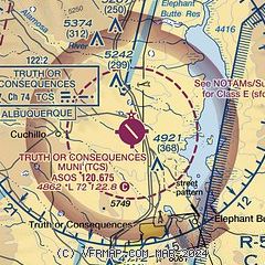
| Sectional chart |
|---|
|
| Airport distance calculator |
|---|
|
|
| Sunrise and sunset |
|---|
|
Times for 19-Jun-2025
| | Local
(UTC-6) | | Zulu
(UTC) |
|---|
| Morning civil twilight | | 05:32 | | 11:32 |
| Sunrise | | 06:01 | | 12:01 |
| Sunset | | 20:20 | | 02:20 |
| Evening civil twilight | | 20:49 | | 02:49 |
|
| Current date and time |
|---|
| Zulu (UTC) | 19-Jun-2025 12:47:18 |
|---|
| Local (UTC-6) | 19-Jun-2025 06:47:18 |
|---|
|
| METAR |
|---|
| KTCS | 191153Z AUTO 28008KT 10SM CLR 22/07 A3011 RMK AO2 SLP096 T02220067 10289 20222 53007
|
|
| TAF |
|---|
| KTCS | 191121Z 1912/2012 28006KT P6SM SKC FM191400 VRB05KT P6SM SKC FM192000 16010G18KT P6SM FEW150 FM200300 13008KT P6SM SKC
|
|
| NOTAMs |
|---|
NOTAMs are issued by the DoD/FAA and will open in a separate window not controlled by AirNav.
|
|


