FAA INFORMATION EFFECTIVE 14 MAY 2026
Location
| FAA Identifier: | UGN |
| Lat/Long: | 42-25-19.7350N 087-52-04.4980W
42-25.328917N 087-52.074967W
42.4221486,-87.8679161
(estimated) |
| Elevation: | 728.1 ft. / 221.9 m (surveyed) |
| Variation: | 03W (2000) |
| From city: | 35 miles N of central business district of the associated city |
| Time zone: | UTC -5 (UTC -6 during Standard Time) |
| Zip code: | 60087 |
Airport Operations
| Airport use: | Open to the public |
| Activation date: | 04/1947 |
| Control tower: | yes |
| ARTCC: | CHICAGO CENTER |
| FSS: | KANKAKEE FLIGHT SERVICE STATION |
| NOTAMs facility: | UGN (NOTAM-D service available) |
| Attendance: | CONTINUOUS |
| Wind indicator: | lighted |
| Segmented circle: | no |
| Lights: | ATCTVT MALSR RWY 23; REIL RWY 05; HIRL RWY 05/23; MIRL RWY 14/32 TWY LGTS - CTAF. WHEN ATCT CLSD TO INCR INTST & ACTVT - CTAF |
| Beacon: | white-green (lighted land airport)
Operates sunset to sunrise. |
| International operations: | FOR US CUSTOMS 2 HRS MIN ADVN NOTICE RQRD MON-FRI
11:00 - 19:00 LCL & BY 4PM FRI FOR WKEND ARRS. CTC
CBP (224)529-1468. |
Airport Communications
| CTAF: | 120.05 |
| ATIS: | 132.4 |
| WX ASOS: | PHONE 847-782-0876 |
| WAUKEGAN GROUND: | 121.65 [0600-2000] |
| WAUKEGAN TOWER: | 120.05 273.55 [0600-2000] |
| CHICAGO APPROACH: | 120.55 |
| CHICAGO DEPARTURE: | 120.55 |
| EMERG: | 121.5 |
| GOPAC STAR: | 126.5 |
| WX ASOS at ENW (11 nm N): | PHONE 262-652-7730 |
| WX ASOS at PWK (19 nm S): | PHONE 847-465-0291 |
- ATCT OPERATED BY CONTRACT WITH ITAP (INTERNATIONAL TECHNICAL AVIATION PERSONNEL INC).
Nearby radio navigation aids
| VOR radial/distance | | VOR name | | Freq | | Var |
|---|
| OBKr019/12.6 | | NORTHBROOK VOR/DME | | 113.00 | | 02W |
| DPAr032/38.4 | | DUPAGE VOR/DME | | 114.55 | | 02E |
| NDB name | | Hdg/Dist | | Freq | | Var | | ID |
|---|
| WAUKE | | 233/3.9 | | 379 | | 03W | | UG | ..- --. |
Airport Services
| Fuel available: | 100LL JET-A
100LL:FUEL IS PRVDD BY A DOD CONTRACT. 100 LL AVBL 24HR WITH CREDIT CARD FM SELF SERVE PUMP ON TSNT RAMP. |
| Parking: | hangars and tiedowns |
| Airframe service: | MAJOR |
| Powerplant service: | MAJOR |
| Bottled oxygen: | HIGH/LOW |
| Bulk oxygen: | HIGH/LOW |
Runway Information
Runway 5/23
| Dimensions: | 6001 x 150 ft. / 1829 x 46 m |
| Surface: | asphalt/grooved, in good condition |
| Weight bearing capacity: | | Single wheel: | 95.0 | | Double wheel: | 120.0 | | Double tandem: | 200.0 |
|
| Runway edge lights: | high intensity |
| RUNWAY 5 | | RUNWAY 23 |
| Latitude: | 42-24.951062N | | 42-25.606318N |
| Longitude: | 087-52.536265W | | 087-51.538462W |
| Elevation: | 725.8 ft. | | 723.4 ft. |
| Traffic pattern: | left | | right |
| Runway heading: | 051 magnetic, 048 true | | 231 magnetic, 228 true |
| Markings: | precision, in good condition | | precision, in good condition |
| Visual slope indicator: | 4-box VASI on left (3.00 degrees glide path) | | 4-box VASI on left (3.00 degrees glide path) |
| Approach lights: | | | MALSR: 1,400 foot medium intensity approach lighting system with runway alignment indicator lights |
| Runway end identifier lights: | yes | | no |
| Touchdown point: | yes, no lights | | yes, no lights |
| Instrument approach: | | | ILS |
| Obstructions: | 12 ft. road, 281 ft. from runway, 502 ft. left of centerline, 6:1 slope to clear | | 1 ft. road, 245 ft. from runway, 500 ft. right of centerline, 45:1 slope to clear |
Runway 14/32
| Dimensions: | 3750 x 75 ft. / 1143 x 23 m |
| Surface: | asphalt, in good condition |
| Weight bearing capacity: | | Single wheel: | 16.0 | | Double wheel: | 23.0 |
|
| Runway edge lights: | medium intensity |
| RUNWAY 14 | | RUNWAY 32 |
| Latitude: | 42-25.659592N | | 42-25.158983N |
| Longitude: | 087-52.378777W | | 087-51.891458W |
| Elevation: | 727.9 ft. | | 712.0 ft. |
| Traffic pattern: | left | | left |
| Runway heading: | 147 magnetic, 144 true | | 327 magnetic, 324 true |
| Displaced threshold: | 489 ft. | | no |
| Markings: | basic, in good condition | | basic, in good condition |
| Visual slope indicator: | 4-box VASI on left (3.50 degrees glide path) | | |
| Runway end identifier lights: | no | | no |
| Touchdown point: | yes, no lights | | yes, no lights |
| Obstructions: | 29 ft. road, 205 ft. from runway, 125 ft. left of centerline, 1:1 slope to clear
APCH RATIO IS 26:1 AT DSPLCD THLD. | | none |
Airport Ownership and Management from official FAA records
| Ownership: | Publicly-owned |
| Owner: | WAUKEGAN PORT DISTRICT
2601 PLANE REST DR.
WAUKEGAN, IL 60087
Phone 847-244-0055 |
| Manager: | SKIP GOSS
2601 PLANE REST DRIVE
WAUKEGAN, IL 60087
Phone 847-244-0055
EMAIL ADDRESS: SGOSS@WAUKEGANPORT.COM |
Additional Remarks
| - | BIRDS ON & INVOF ARPT. |
| - | FOR CD WHEN ATCT IS CLSD CTC CHICAGO APCH AT 847-289-0926. |
Instrument Procedures
NOTE: All procedures below are presented as PDF files. If you need a reader for these files, you should download the free Adobe Reader.NOT FOR NAVIGATION. Please procure official charts for flight.
FAA instrument procedures published for use from 14 May 2026 at 0901Z to 11 June 2026 at 0900Z.
STARs - Standard Terminal Arrivals |
|---|
| GOPAC THREE (RNAV) | |
download (234KB) |
IAPs - Instrument Approach Procedures |
|---|
| ILS OR LOC RWY 23 | |
download (236KB) |
| RNAV (GPS) RWY 05 | |
download (223KB) |
| RNAV (GPS) RWY 23 | |
download (222KB) |
| NOTE: Special Alternate Minimums apply | |
download (139KB) |
Departure Procedures |
|---|
| JORJO FIVE (RNAV) | |
2 pages:
[1] [2] (324KB) |
| MONKZ FIVE (RNAV) | |
2 pages:
[1] [2] (367KB) |
| NOTE: Special Take-Off Minimums/Departure Procedures apply | |
download (482KB) |
Other nearby airports with instrument procedures:
KENW - Kenosha Regional Airport (11 nm N)
C81 - Campbell Airport (11 nm SW)
KPWK - Chicago Executive Airport (19 nm S)
KRAC - Batten International Airport (20 nm N)
10C - Galt Field Airport (22 nm W)
|
|

Road maps at:
MapQuest
Bing
Google
| Aerial photo |
|---|
WARNING: Photo may not be current or correct
 Photo taken 31-May-2018
looking southeast.
Photo taken 31-May-2018
looking southeast.
Do you have a better or more recent aerial photo of Waukegan National Airport that you would like to share? If so, please send us your photo.
|
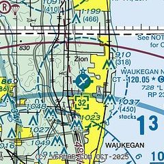
| Sectional chart |
|---|
|
 Download PDF
of official airport diagram from the FAA
| Airport distance calculator |
|---|
|
|
| Sunrise and sunset |
|---|
|
Times for 23-May-2026
| | Local
(UTC-5) | | Zulu
(UTC) |
|---|
| Morning civil twilight | | 04:50 | | 09:50 |
| Sunrise | | 05:24 | | 10:24 |
| Sunset | | 20:13 | | 01:13 |
| Evening civil twilight | | 20:46 | | 01:46 |
|
| Current date and time |
|---|
| Zulu (UTC) | 24-May-2026 02:22:46 |
|---|
| Local (UTC-5) | 23-May-2026 21:22:46 |
|---|
|
| METAR |
|---|
| KUGN | 240151Z AUTO 09005KT 8SM CLR 10/09 A3001 RMK AO2 SLP164 T01000094
|
KENW
11nm N | 240153Z 10006KT 10SM CLR 11/09 A3003 RMK AO2 SLP169 T01110094
|
KPWK
18nm S | 240152Z 10005KT 10SM FEW080 FEW100 12/11 A3002 RMK AO2 SLP167 T01220106
|
|
| TAF |
|---|
KENW
11nm N | 231951Z 2320/2418 10009KT P6SM SCT050 BKN070 FM240400 20005KT 6SM -SHRA BKN035 FM241000 00000KT P6SM SCT150 FM241300 29007KT P6SM SKC FM241600 30010G18KT P6SM SKC
|
|
| NOTAMs |
|---|
NOTAMs are issued by the DoD/FAA and will open in a separate window not controlled by AirNav.
|
|


