FAA INFORMATION EFFECTIVE 19 MARCH 2026
Location
| FAA Identifier: | YKN |
| Lat/Long: | 42-55-00.0430N 097-23-09.3540W
42-55.000717N 097-23.155900W
42.9166786,-97.3859317
(estimated) |
| Elevation: | 1305.9 ft. / 398.0 m (surveyed) |
| Variation: | 03E (2025) |
| From city: | 3 miles N of YANKTON, SD |
| Time zone: | UTC -5 (UTC -6 during Standard Time) |
| Zip code: | 57078 |
Airport Operations
| Airport use: | Open to the public |
| Activation date: | 12/1937 |
| Control tower: | no |
| ARTCC: | MINNEAPOLIS CENTER |
| FSS: | HURON FLIGHT SERVICE STATION |
| NOTAMs facility: | YKN (NOTAM-D service available) |
| Attendance: | MON-FRI 0800-1700
FOR SVC AFT 1700 CALL 605-661-9223. |
| Wind indicator: | lighted |
| Segmented circle: | yes |
| Lights: | ACTVT MALSR RWY 31; REILS RWY 13; PAPI RWY 02 & 20; HIRL RWY 13/31; MIRL RWY 02/20 - CTAF. |
| Beacon: | white-green (lighted land airport)
Operates sunset to sunrise. |
Airport Communications
| CTAF/UNICOM: | 122.8 |
| WX AWOS-3PT: | 119.05 (605-665-6072) |
- APCH/DEP SVC PRVDD BY MINNEAPOLIS ARTCC ON FREQS 125.025/235.625 (SIOUX CITY RCAG).
Airport Services
| Fuel available: | 100LL JET-A |
| Parking: | hangars and tiedowns |
| Airframe service: | MAJOR |
| Powerplant service: | MAJOR |
| Bottled oxygen: | NONE |
| Bulk oxygen: | NONE |
Runway Information
Runway 13/31
| Dimensions: | 6094 x 100 ft. / 1857 x 30 m |
| Surface: | concrete, in excellent condition |
| Weight bearing capacity: | | Single wheel: | 30.0 | | Double wheel: | 50.0 | | Double tandem: | 90.0 |
|
| Runway edge lights: | high intensity |
| RUNWAY 13 | | RUNWAY 31 |
| Latitude: | 42-55.457868N | | 42-54.692210N |
| Longitude: | 097-23.661130W | | 097-22.779200W |
| Elevation: | 1305.9 ft. | | 1270.6 ft. |
| Traffic pattern: | left | | left |
| Runway heading: | 137 magnetic, 140 true | | 317 magnetic, 320 true |
| Markings: | precision, in fair condition | | precision, in fair condition |
| Visual slope indicator: | 4-box VASI on left (3.00 degrees glide path) | | 4-box VASI on left (3.00 degrees glide path) |
| Approach lights: | | | MALSR: 1,400 foot medium intensity approach lighting system with runway alignment indicator lights |
| Runway end identifier lights: | yes | | |
| Touchdown point: | yes, no lights | | yes, no lights |
| Instrument approach: | | | ILS |
Runway 2/20
| Dimensions: | 3380 x 60 ft. / 1030 x 18 m |
| Surface: | asphalt, in excellent condition |
| Weight bearing capacity: | |
| Runway edge lights: | medium intensity |
| RUNWAY 2 | | RUNWAY 20 |
| Latitude: | 42-54.607735N | | 42-55.125635N |
| Longitude: | 097-23.178388W | | 097-22.901830W |
| Elevation: | 1273.6 ft. | | 1281.7 ft. |
| Traffic pattern: | left | | left |
| Runway heading: | 018 magnetic, 021 true | | 198 magnetic, 201 true |
| Markings: | nonprecision, in good condition | | nonprecision, in good condition |
| Visual slope indicator: | 2-light PAPI on left (3.00 degrees glide path) | | 2-light PAPI on left (3.00 degrees glide path) |
| Runway end identifier lights: | no | | no |
| Touchdown point: | yes, no lights | | yes, no lights |
| Obstructions: | 7 ft. pline, marked, 385 ft. from runway, 94 ft. right of centerline, 26:1 slope to clear | | 6 ft. fence, 382 ft. from runway, 11 ft. right of centerline, 30:1 slope to clear |
Airport Ownership and Management from official FAA records
| Ownership: | Publicly-owned |
| Owner: | CITY OF YANKTON
PO BOX 176
YANKTON, SD 57078
Phone 605-668-5288 |
| Manager: | MIKE ROINSTAD
700 EAST 31ST STREET
YANKTON, SD 57078
Phone 605-661-9223 |
Additional Remarks
| - | MIGRATORY WATERFOWL ON & INVOF ARPT. |
| - | PAEW MOWING SEASONAL. |
| - | FOR CD CTC MINNEAPOLIS ARTCC AT 651-463-5588. |
Instrument Procedures
NOTE: All procedures below are presented as PDF files. If you need a reader for these files, you should download the free Adobe Reader.NOT FOR NAVIGATION. Please procure official charts for flight.
FAA instrument procedures published for use from 19 March 2026 at 0901Z to 16 April 2026 at 0900Z.
IAPs - Instrument Approach Procedures |
|---|
| ILS OR LOC RWY 31 | |
download (254KB) |
| RNAV (GPS) RWY 13 | |
download (218KB) |
| RNAV (GPS) RWY 31 | |
download (221KB) |
| NOTE: Special Alternate Minimums apply | |
download (176KB) |
| NOTE: Special Take-Off Minimums/Departure Procedures apply | |
download (396KB) |
Other nearby airports with instrument procedures:
0B4 - Hartington Municipal Airport/Bud Becker Field (20 nm S)
KVMR - Harold Davidson Field Airport (22 nm SE)
6K3 - Creighton Municipal Airport (35 nm SW)
8V3 - Parkston Municipal Airport (38 nm NW)
KAGZ - Wagner Municipal Airport (41 nm W)
|
|

Road maps at:
MapQuest
Bing
Google
| Aerial photo |
|---|
WARNING: Photo may not be current or correct
 Photo by Steve Hamilton
Do you have a better or more recent aerial photo of Chan Gurney Municipal Airport that you would like to share? If so, please send us your photo.
|
| Sectional chart |
|---|
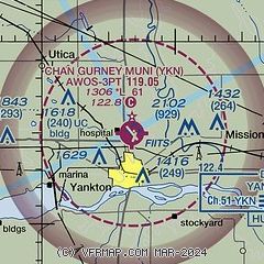
|
| Airport distance calculator |
|---|
|
|
| Sunrise and sunset |
|---|
|
Times for 15-Apr-2026
| | Local
(UTC-5) | | Zulu
(UTC) |
|---|
| Morning civil twilight | | 06:19 | | 11:19 |
| Sunrise | | 06:49 | | 11:49 |
| Sunset | | 20:11 | | 01:11 |
| Evening civil twilight | | 20:40 | | 01:40 |
|
| Current date and time |
|---|
| Zulu (UTC) | 15-Apr-2026 07:10:30 |
|---|
| Local (UTC-5) | 15-Apr-2026 02:10:30 |
|---|
|
| METAR |
|---|
| KYKN | 150656Z AUTO 32006KT 10SM CLR 06/03 A2976 RMK AO2 SLP091 T00560033
|
|
| TAF |
|---|
KFSD
49nm NE | 150524Z 1506/1606 VRB04KT P6SM SCT250 FM151800 08006KT P6SM BKN250 FM160300 16005KT P6SM FEW250
|
|
| NOTAMs |
|---|
NOTAMs are issued by the DoD/FAA and will open in a separate window not controlled by AirNav.
|
|

