FAA INFORMATION EFFECTIVE 02 OCTOBER 2025
Location
| FAA Identifier: | T31 |
| Lat/Long: | 33-12-30.4200N 096-44-30.9880W
33-12.507000N 096-44.516467W
33.2084500,-96.7419411
(estimated) |
| Elevation: | 765 ft. / 233 m (estimated) |
| Variation: | 06E (1985) |
| From city: | 4 miles W of MC KINNEY, TX |
| Time zone: | UTC -5 (UTC -6 during Standard Time) |
| Zip code: | 75070 |
Airport Operations
| Airport use: | Open to the public |
| Activation date: | 11/1976 |
| Control tower: | no |
| ARTCC: | FORT WORTH CENTER |
| FSS: | FORT WORTH FLIGHT SERVICE STATION |
| NOTAMs facility: | FTW (NOTAM-D service available) |
| Attendance: | UNATNDD |
| Pattern altitude: | 1800 ft. MSL |
| Wind indicator: | yes |
| Segmented circle: | no |
| Lights: | MIRL RWY 17/35 PRESET LOW INTST SS-SR; TO INCR INTST ACTVT - CTAF. |
| Beacon: | white-green (lighted land airport)
Operates sunset to sunrise. |
Airport Communications
| CTAF: | 122.9 |
| WX ASOS at TKI (8 nm E): | PHONE 972-548-8525 |
| WX AWOS-3PT at ADS (15 nm S): | PHONE 972-386-4855 |
Nearby radio navigation aids
| VOR radial/distance | | VOR name | | Freq | | Var |
|---|
| CVEr017/20.8 | | COWBOY VOR/DME | | 116.20 | | 06E |
| TTTr030/25.3 | | MAVERICK VOR/DME | | 113.10 | | 06E |
| FUZr043/29.2 | | RANGER VORTAC | | 115.70 | | 06E |
| BYPr226/32.2 | | BONHAM VORTAC | | 114.60 | | 06E |
| NDB name | | Hdg/Dist | | Freq | | Var | | ID |
|---|
| DENISON | | 183/37.3 | | 341 | | 03E | | DNI | -.. -. .. |
Airport Services
| Fuel available: | 100LL
100LL:FUEL 24 HRS SELF-SERVE. |
| Airframe service: | MAJOR |
| Powerplant service: | MAJOR |
Runway Information
Runway 17/35
| Dimensions: | 4352 x 60 ft. / 1326 x 18 m |
| Surface: | asphalt/turf, in good condition
3002 FT ASPH ON S END, 1350 FT TURF ON N END. |
| Weight bearing capacity: | | Single wheel: | 6.5, RSTRD TO ACFT LESS THAN 6500 LBS. |
|
| Runway edge lights: | medium intensity
NSTD MIRL; ONLY SOUTH 3002 FT IS LGTD. |
| Runway edge markings: | DSPLCD THR ONLY MKD ON WEST SIDE OF RWY. |
| RUNWAY 17 | | RUNWAY 35 |
| Traffic pattern: | left | | left |
| Displaced threshold: | 300 ft. | | 245 ft. |
| Markings: | nonprecision, in good condition | | nonprecision, in good condition |
| Obstructions: | 34 ft. tree, 66 ft. left of centerline, 1:1 slope to clear
APCH SLOPE 0:1 AT DTHR, 28 FT TREES, 0 FT DSTC, 112 FT L. | | 8 ft. hill, 201 ft. from runway
+6 FT FENCE 25 FT 0B; +15 FT RD 55 FT 0B. |
Airport Ownership and Management from official FAA records
| Ownership: | Privately-owned |
| Owner: | AERO COUNTRY PROPERTY
P.O. BOX 6329
MC KINNEY, TX 75071
Phone 972-346-8109
OWNERS ASSOCIATION. |
| Manager: | PRESIDENT ACPOA
P.O. BOX 6329
MC KINNEY, TX 75071
Phone 972-346-8109 |
Additional Remarks
| - | TKOF & LNDG ONLY ON RWY. OTHER AREAS NOT MAINTAINED FOR ACFT OPNS. |
| - | RWY HOLD SHORT LINES 75 FT FM RWY CNTRLN. |
| - | 50 FT TREES 125 FT EAST OF RWY CNTRLN FM NORTH END OF RWY TO 3050 FT SOUTH. |
| - | FOR DRONE OPERATION REQUESTS & PERMISSION, SEE ARPT WEB SIDE, WWW.AEROCOUNTRY.ORG. |
| - | FOR CD CTC REGIONAL APCH AT 972-615-2799. |
| - | ALPHA TWY 20 FT WIDE, TWY TO FUEL SYSTEM 18 FT WIDE. WATCH FOR AUTOS, PEDESTRIANS, SIGNS, AND TRASH CANS ON TWY. |
| - | THE CALM WIND RWY 17. |
| - | NO TSNT PRKG AREA. |
| - | DUE TO RWY SLOPE, ACFT NOT VSB FM OPPOSITE END. |
| - | STEEP DOWNSLOPE 50 FT EAST OF CNTRLN, SOUTH END. |
| - | ARPT CLSD TO TSNT FLT TRNG, NO TSNT TGL. |
| - | RESIDENTIAL AIRPARK, VEHICLES ON TWYS. |
| - | NOISE SENSITIVE AREAS AROUND ARPT. |
Instrument Procedures
There are no published instrument procedures at T31.
Some nearby airports with instrument procedures:
KTKI - McKinney National Airport (8 nm E)
KADS - Addison Airport (15 nm S)
KDAL - Dallas Love Field Airport (22 nm S)
F46 - Ralph M Hall/Rockwall Municipal Airport (23 nm SE)
KDTO - Denton Enterprise Airport (23 nm W)
|
|

Road maps at:
MapQuest
Bing
Google
| Aerial photo |
|---|
WARNING: Photo may not be current or correct
 As seen circa 2017
looking southeast.
As seen circa 2017
looking southeast.
Do you have a better or more recent aerial photo of Aero Country Airport that you would like to share? If so, please send us your photo.
|
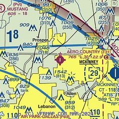
| Sectional chart |
|---|
|
| Airport distance calculator |
|---|
|
|
| Sunrise and sunset |
|---|
|
Times for 20-Oct-2025
| | Local
(UTC-5) | | Zulu
(UTC) |
|---|
| Morning civil twilight | | 07:11 | | 12:11 |
| Sunrise | | 07:36 | | 12:36 |
| Sunset | | 18:47 | | 23:47 |
| Evening civil twilight | | 19:12 | | 00:12 |
|
| Current date and time |
|---|
| Zulu (UTC) | 21-Oct-2025 01:33:46 |
|---|
| Local (UTC-5) | 20-Oct-2025 20:33:46 |
|---|
|
| METAR |
|---|
KTKI
8nm E | 210053Z 16005KT 10SM CLR 24/17 A2984 RMK AO2 SLP106 T02390167
|
KADS
15nm S | 210047Z 16006KT 13SM SKC 29/15 A2985
|
|
| TAF |
|---|
KDAL
22nm S | 202050Z 2021/2118 21014G24KT P6SM SKC FM210000 18014KT P6SM SKC FM210400 01014KT P6SM FEW050
|
KDFW
23nm SW | 202050Z 2021/2124 20021G32KT P6SM SKC FM210000 18014KT P6SM SKC FM210400 01014KT P6SM FEW050
|
|
| NOTAMs |
|---|
NOTAMs are issued by the DoD/FAA and will open in a separate window not controlled by AirNav.
|
|


