FAA INFORMATION EFFECTIVE 19 MARCH 2026
Location
| FAA Identifier: | X23 |
| Lat/Long: | 28-55-29.0460N 081-39-06.4120W
28-55.484100N 081-39.106867W
28.9247350,-81.6517811
(estimated) |
| Elevation: | 106 ft. / 32.3 m (surveyed) |
| Variation: | 06W (2015) |
| From city: | 1 mile E of UMATILLA, FL |
| Time zone: | UTC -4 (UTC -5 during Standard Time) |
| Zip code: | 32784 |
Airport Operations
| Airport use: | Open to the public |
| Activation date: | 03/1948 |
| Control tower: | no |
| ARTCC: | JACKSONVILLE CENTER |
| FSS: | SAINT PETERSBURG FLIGHT SERVICE STATION |
| NOTAMs facility: | PIE (NOTAM-D service available) |
| Attendance: | TUE-FRI 0800-1200 |
| Wind indicator: | lighted |
| Segmented circle: | yes |
| Lights: | ACTVT PAPI RWY 01 & 19; MIRL RWY 01/19- CTAF. |
| Beacon: | white-green (lighted land airport)
Operates sunset to sunrise. |
Airport Communications
| CTAF: | 122.9 |
| ORLANDO APPROACH: | 135.3 |
| ORLANDO DEPARTURE: | 135.3 |
| WX ASOS at LEE (10 nm SW): | PHONE 352-787-1565 |
Nearby radio navigation aids
| VOR radial/distance | | VOR name | | Freq | | Var |
|---|
| ORLr324/28.3 | | ORLANDO VORTAC | | 112.20 | | 00E |
| OCFr117/33.7 | | OCALA VORTAC | | 113.70 | | 00E |
| OMNr231/36.3 | | ORMOND BEACH VORTAC | | 112.60 | | 00E |
Airport Services
| Fuel available: | 100 100LL |
| Parking: | tiedowns |
| Airframe service: | NONE |
| Powerplant service: | NONE |
| Bottled oxygen: | NONE |
| Bulk oxygen: | NONE |
Runway Information
Runway 1/19
| Dimensions: | 2876 x 60 ft. / 877 x 18 m |
| Surface: | asphalt, in excellent condition |
| Weight bearing capacity: | | PCN 8 /F/A/Y/T | | Single wheel: | 31.0 | | Double wheel: | 48.0 |
|
| Runway edge lights: | medium intensity |
| RUNWAY 1 | | RUNWAY 19 |
| Latitude: | 28-55.247223N | | 28-55.721035N |
| Longitude: | 081-39.121940W | | 081-39.091730W |
| Elevation: | 100.6 ft. | | 105.7 ft. |
| Traffic pattern: | left | | left |
| Runway heading: | 009 magnetic, 003 true | | 189 magnetic, 183 true |
| Displaced threshold: | 201 ft. | | no |
| Markings: | nonprecision, in good condition | | nonprecision, in good condition |
| Visual slope indicator: | 2-light PAPI on right (3.50 degrees glide path) | | 2-light PAPI on left (3.50 degrees glide path) |
| Touchdown point: | yes, no lights | | yes, no lights |
| Obstructions: | 37 ft. trees, 380 ft. from runway, 125 ft. left of centerline, 4:1 slope to clear
RWY 01 APCH SLP 16:1 TO DTHR. | | 16 ft. brush, 340 ft. from runway, 30 ft. left of centerline, 8:1 slope to clear
RWY 19 APCH SLP 24:1 TO DTHR. |
Airport Ownership and Management from official FAA records
| Ownership: | Publicly-owned |
| Owner: | CITY OF UMATILLA
PO BOX 2286
UMATILLA, FL 32784-2286
Phone 352-669-3125 |
| Manager: | AARON MERCER
PO BOX 2286
UMATILLA, FL 32784-2286
Phone 352-669-3125
AIRPORT PHYSICAL ADDRESS: 1 UMATILLA AIRPORT WAY, UMATILLA, FL 32784 |
Additional Remarks
| - | FOR CD OR TO CNL IFR CTC ORLANDO APCH AT 407-852-7500. |
| - | UNLGTD OBSTRUCTIONS IN THE APPRCH TO RWY 01 DUE TO TREES 380 FT BFR AER. |
Instrument Procedures
NOTE: All procedures below are presented as PDF files. If you need a reader for these files, you should download the free Adobe Reader.NOT FOR NAVIGATION. Please procure official charts for flight.
FAA instrument procedures published for use from 19 March 2026 at 0901Z to 16 April 2026 at 0900Z.
IAPs - Instrument Approach Procedures |
|---|
| RNAV (GPS)-A | |
download (181KB) |
| RNAV (GPS)-B | |
download (188KB) |
| NOTE: Special Take-Off Minimums/Departure Procedures apply | |
download (404KB) |
Other nearby airports with instrument procedures:
KLEE - Leesburg International Airport (10 nm SW)
X04 - Orlando Apopka Airport (14 nm S)
KDED - DeLand Municipal Airport-Sidney H Taylor Field (21 nm NE)
KSFB - Orlando Sanford International Airport (24 nm E)
KORL - Orlando Executive Airport (28 nm SE)
|
|

Road maps at:
MapQuest
Bing
Google
| Aerial photo |
|---|
WARNING: Photo may not be current or correct
 Photo taken 04-Nov-2011
looking southeast.
Photo taken 04-Nov-2011
looking southeast.
Do you have a better or more recent aerial photo of Umatilla Municipal Airport that you would like to share? If so, please send us your photo.
|
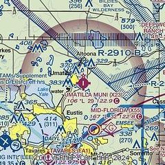
| Sectional chart |
|---|
|
| Airport distance calculator |
|---|
|
|
| Sunrise and sunset |
|---|
|
Times for 10-Apr-2026
| | Local
(UTC-4) | | Zulu
(UTC) |
|---|
| Morning civil twilight | | 06:43 | | 10:43 |
| Sunrise | | 07:07 | | 11:07 |
| Sunset | | 19:49 | | 23:49 |
| Evening civil twilight | | 20:13 | | 00:13 |
|
| Current date and time |
|---|
| Zulu (UTC) | 10-Apr-2026 04:38:13 |
|---|
| Local (UTC-4) | 10-Apr-2026 00:38:13 |
|---|
|
| METAR |
|---|
KLEE
11nm SW | 100353Z AUTO 02006KT 10SM FEW031 18/16 A3023 RMK AO2 SLP236 T01780161
|
|
| TAF |
|---|
KLEE
11nm SW | 091720Z 0918/1018 06016G25KT P6SM VCSH FEW025 BKN035 BKN100 FM092000 05020G27KT P6SM VCSH SCT025 BKN035 FM100200 03009KT P6SM BKN035 BKN100 FM101400 05012G20KT P6SM FEW020 SCT045
|
|
| NOTAMs |
|---|
NOTAMs are issued by the DoD/FAA and will open in a separate window not controlled by AirNav.
|
|


