FAA INFORMATION EFFECTIVE 19 MARCH 2026
Location
| FAA Identifier: | 12J |
| Lat/Long: | 31-03-02.5610N 087-04-02.1600W
31-03.042683N 087-04.036000W
31.0507114,-87.0672667
(estimated) |
| Elevation: | 98.8 ft. / 30.1 m (surveyed) |
| Variation: | 01W (2000) |
| From city: | 3 miles S of BREWTON, AL |
| Time zone: | UTC -5 (UTC -6 during Standard Time) |
| Zip code: | 36426 |
Airport Operations
| Airport use: | Open to the public |
| Activation date: | 06/1944 |
| Control tower: | no |
| ARTCC: | JACKSONVILLE CENTER |
| FSS: | ANNISTON FLIGHT SERVICE STATION |
| NOTAMs facility: | ANB (NOTAM-D service available) |
| Attendance: | MON-FRI 0730-1700, ALL SAT 0830-1700
AFT HRS CALL 251-867-9997. |
| Wind indicator: | lighted |
| Segmented circle: | no |
| Lights: | ACTVT PAPI RWY 12 & 30; MIRL RWY 12/30 - CTAF. |
| Beacon: | white-green (lighted land airport)
Operates sunset to sunrise. |
Airport Communications
| CTAF/UNICOM: | 122.725 |
| WX AWOS-3PT: | 119.325 (251-809-2987) |
| PENSACOLA APPROACH: | 127.35 |
| PENSACOLA DEPARTURE: | 127.35 |
| WX ASOS at NSE (20 nm S): | PHONE 850-623-7241 |
Nearby radio navigation aids
| VOR radial/distance | | VOR name | | Freq | | Var |
|---|
| CEWr301/24.1 | | CRESTVIEW VORTAC | | 115.90 | | 03E |
| MVCr145/28.6 | | MONROEVILLE VORTAC | | 116.80 | | 04E |
| NUNr021/(37.4) | | SAUFLEY VOR | | 112.25 | | 01E |
Airport Services
| Fuel available: | 100LL JET-A+ |
| Parking: | hangars and tiedowns |
| Airframe service: | MAJOR |
| Powerplant service: | MAJOR |
| Bottled oxygen: | NONE |
| Bulk oxygen: | NONE |
Runway Information
Runway 6/24
| Dimensions: | 5136 x 150 ft. / 1565 x 46 m |
| Surface: | asphalt, in fair condition |
| Weight bearing capacity: | | Single wheel: | 40.0 | | Double wheel: | 60.0 |
|
| Runway edge markings: | MARKINGS FADED, CNTLN OBSCURED. |
| RUNWAY 6 | | RUNWAY 24 |
| Latitude: | 31-02.998458N | | 31-03.384532N |
| Longitude: | 087-04.547052W | | 087-03.671163W |
| Elevation: | 80.9 ft. | | 83.3 ft. |
| Traffic pattern: | left | | left |
| Runway heading: | 064 magnetic, 063 true | | 244 magnetic, 243 true |
| Markings: | nonprecision, in fair condition | | nonprecision, in fair condition |
| Touchdown point: | yes, no lights | | yes, no lights |
| Obstructions: | 10 ft. tree, 245 ft. from runway, 48 ft. left of centerline, 4:1 slope to clear | | 97 ft. trees, 1308 ft. from runway, 92 ft. left of centerline, 11:1 slope to clear |
Runway 12/30
| Dimensions: | 5001 x 150 ft. / 1524 x 46 m |
| Surface: | asphalt, in poor condition
SFC EXPERIENCING EXTSV CRACKING. |
| Weight bearing capacity: | | Single wheel: | 40.0 | | Double wheel: | 60.0 |
|
| Runway edge lights: | medium intensity |
| Runway edge markings: | MARKINGS FADED, CNTLN OBSCURED.
FIXED DISTANCE MARKER 500 FT FM RWY END. |
| RUNWAY 12 | | RUNWAY 30 |
| Latitude: | 31-03.095260N | | 31-02.684430N |
| Longitude: | 087-04.376370W | | 087-03.545472W |
| Elevation: | 82.1 ft. | | 98.8 ft. |
| Traffic pattern: | left | | left |
| Runway heading: | 121 magnetic, 120 true | | 301 magnetic, 300 true |
| Markings: | nonprecision, in fair condition | | nonprecision, in fair condition |
| Visual slope indicator: | 2-light PAPI on left (3.25 degrees glide path)
UNUSBL BYD 6 DEG LEFT OF CNTRLN. | | 2-light PAPI on left (3.50 degrees glide path) |
| Touchdown point: | yes, no lights | | yes, no lights |
| Obstructions: | 90 ft. trees, 1913 ft. from runway, 138 ft. left of centerline, 19:1 slope to clear | | none
BRUSH LCTD 79 FT FM RWY END, 91 FT LEFT OF CNTLN. |
Airport Ownership and Management from official FAA records
| Ownership: | Publicly-owned |
| Owner: | CITY OF BREWTON
PO BOX 368
BREWTON, AL 36427
Phone 251-867-3281 |
| Manager: | MONTE MCGOUGHIN
111 DOGWOOD LANE W.
BREWTON, AL 36426
Phone 251-363-1551 |
Additional Remarks
| - | USN PILOT TRNG FM WHITING FLD. |
| - | FOR CD CTC PENSACOLA APCH AT 850-266-6884 OR 850-266-6885. |
| - | MILITARY: MISC: OPR 1245-2230Z++ MON - FRI; SAT - SUN AS RQRD; CLSD HOL. MIL TRNG ACFT MNT UNICOM AND YIELD TO ALL CIV OPR. VFR TFC RQR TO STAY AT OR BLW 1000 FT AGL ON APCH TO ARPT. MIL ACFT RRQ PRIOR COORD WITH NAS WHITING FLD, DSN 868-7475, C850-623-7475. |
Instrument Procedures
NOTE: All procedures below are presented as PDF files. If you need a reader for these files, you should download the free Adobe Reader.NOT FOR NAVIGATION. Please procure official charts for flight.
FAA instrument procedures published for use from 19 March 2026 at 0901Z to 16 April 2026 at 0900Z.
IAPs - Instrument Approach Procedures |
|---|
| RNAV (GPS) RWY 06 | |
download (186KB) |
| RNAV (GPS) RWY 12 | |
download (253KB) |
| RNAV (GPS) RWY 24 | |
download (192KB) |
| RNAV (GPS) RWY 30 | |
download (257KB) |
| VOR/DME RWY 30 | |
download (230KB) |
| NOTE: Special Take-Off Minimums/Departure Procedures apply | |
download (189KB) |
Other nearby airports with instrument procedures:
0R1 - Atmore Municipal Airport (20 nm W)
KNSE - Whiting Field Naval Air Station North (20 nm S)
KNDZ - Whiting Field Naval Air Station South (21 nm S)
KGZH - Evergreen Regional Airport/Middleton Field (22 nm N)
2R4 - Peter Prince Field Airport (25 nm S)
|
|

Road maps at:
MapQuest
Bing
Google
| Aerial photo |
|---|
WARNING: Photo may not be current or correct
 Photo by Ryan Hegerty, 11-Jan-2004
Do you have a better or more recent aerial photo of Brewton Municipal Airport that you would like to share? If so, please send us your photo.
|
| Sectional chart |
|---|
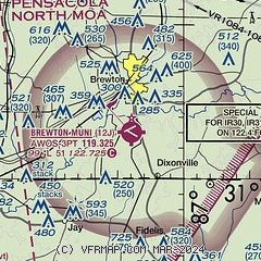
|
| Airport distance calculator |
|---|
|
|
| Sunrise and sunset |
|---|
|
Times for 26-Mar-2026
| | Local
(UTC-5) | | Zulu
(UTC) |
|---|
| Morning civil twilight | | 06:21 | | 11:21 |
| Sunrise | | 06:46 | | 11:46 |
| Sunset | | 19:02 | | 00:02 |
| Evening civil twilight | | 19:27 | | 00:27 |
|
| Current date and time |
|---|
| Zulu (UTC) | 26-Mar-2026 06:52:04 |
|---|
| Local (UTC-5) | 26-Mar-2026 01:52:04 |
|---|
|
| METAR |
|---|
KNSE
20nm S | 260556Z AUTO 13003KT 6SM BR CLR 14/14 A3015 RMK AO2 SLP194 T01440144 10194 20144 402610144 58008 $
|
KNDZ
21nm S | 260556Z 14003KT 8SM CLR 15/15 A3015 RMK AO2 SLP194 T01500150 10189 20150 402560150 58008 $
|
KGZH
22nm N | 260553Z AUTO 00000KT 8SM CLR 16/15 A3015 RMK AO2 SLP208 T01560150 10228 20156 402560133 58005
|
KCEW
33nm SE | 260632Z AUTO 00000KT 5SM BR BKN004 12/12 A3016 RMK AO2 T01220117
|
KNFJ
33nm S | 260617Z AUTO 09003KT 3SM BR BKN007 14/13 A3015 RMK AO2 T01390133 $
|
KPNS
35nm S | 260553Z 00000KT 10SM CLR 17/16 A3014 RMK AO2 SLP209 T01670161 10189 20167 402220167 58007
|
K79J
38nm NE | 260556Z AUTO 00000KT 9SM CLR 15/14 A3015 RMK AO2 SLP206 T01500144 10222 20150 58007 TSNO
|
KEGI
38nm SE | 260555Z AUTO 00000KT 10SM CLR 13/12 A3015 RMK AO2 SLP210 T01340123 10203 20132 402670132 58006 $
|
K0J4
39nm E | 260558Z AUTO 00000KT 10SM CLR 14/13 A3017 RMK AO2 SLP215 60000 T01440133 10222 20139 58008
|
|
| TAF |
|---|
KNSE
20nm S | 2523/2623 16008KT 9999 SCT040 SCT250 QNH3011INS TEMPO 2604/2607 VRB05KT 3200 BR BKN005 FM260700 VRB04KT 0800 FG VV002 QNH3012INS FM261400 13006KT 9999 BKN006 QNH3018INS FM261600 18008KT 9999 SCT020 BKN250 QNH3015INS FM261800 19010G15KT 9999 SCT035 SCT250 QNH3009INS AUTOMATED SENSOR METWATCH 2604 TIL 2611 TX28/2619Z TN14/2609Z FN20029
|
|
| NOTAMs |
|---|
NOTAMs are issued by the DoD/FAA and will open in a separate window not controlled by AirNav.
|
|

