FAA INFORMATION EFFECTIVE 16 APRIL 2026
Location
| FAA Identifier: | 1S2 |
| Lat/Long: | 48-15-31.0050N 121-36-36.7330W
48-15.516750N 121-36.612217W
48.2586125,-121.6102036
(estimated) |
| Elevation: | 553 ft. / 169 m (estimated) |
| Variation: | 21E (1985) |
| Time zone: | UTC -7 (UTC -8 during Standard Time) |
| Zip code: | 98241 |
Airport Operations
| Airport use: | Open to the public |
| Activation date: | 01/1948 |
| Control tower: | no |
| ARTCC: | SEATTLE CENTER |
| FSS: | SEATTLE FLIGHT SERVICE STATION |
| NOTAMs facility: | SEA (NOTAM-D service available) |
| Attendance: | UNATNDD |
| Wind indicator: | lighted |
| Segmented circle: | no |
| Lights: | ACTVT MIRL RWY 10/28 - CTAF. |
| Beacon: | white-green (lighted land airport)
ARPT BCN OTS. Operates sunset to sunrise. |
Airport Communications
Nearby radio navigation aids
| VOR radial/distance | | VOR name | | Freq | | Var |
|---|
| PAEr033/33.6 | | PAINE VOR/DME | | 110.60 | | 20E |
Airport Services
| Parking: | tiedowns |
| Airframe service: | NONE |
| Powerplant service: | NONE |
| Bottled oxygen: | NONE |
| Bulk oxygen: | NONE |
Runway Information
Runway 10/28
| Dimensions: | 2491 x 40 ft. / 759 x 12 m |
| Surface: | asphalt, in good condition |
| Runway edge lights: | medium intensity
MIRL RY 10/28 OTS INDEFLY. |
| RUNWAY 10 | | RUNWAY 28 |
| Latitude: | 48-15.588983N | | 48-15.444517N |
| Longitude: | 121-36.899333W | | 121-36.325117W |
| Elevation: | 544.0 ft. | | 553.0 ft. |
| Traffic pattern: | left | | left |
| Runway heading: | 090 magnetic, 111 true | | 270 magnetic, 291 true |
| Markings: | basic, in good condition | | basic, in good condition |
| Obstructions: | 65 ft. trees, 905 ft. from runway, 10:1 slope to clear
FENCE AT 40 FT, 104 FT R; 3 FT SIGN, 65 FT R, 29 FT FM THLD. | | 15 ft. road, 305 ft. from runway, 126 ft. left of centerline, 7:1 slope to clear
LOGS 78 FT R, ROAD 90 FT R, 35 FT TREES 118 FT R. |
Airport Ownership and Management from official FAA records
| Ownership: | Publicly-owned |
| Owner: | TOWN OF DARRINGTON
P.O. BOX 397
DARRINGTON, WA 98241
Phone 360-436-1131 |
| Manager: | JIM HALE
P.O. BOX 312
DARRINGTON, WA 98241
Phone 360-631-1928
MANAGER'S CELL PHONE NUMBER IS 360-631-1928. |
Additional Remarks
| - | CLSD WHEN SNOW ON RY. |
| - | TURB ON HOT DAYS LNDG W IN TRSN EAST APPROACH. |
| - | TWYS MARKED WITH BLUE REFLECTORS. |
| - | FOR CD CTC SEATTLE ARTCC AT 253-351-3694. |
| - | TWYS ROUGH PAVEMENT WITH SWALES AND DEPRESSIONS. |
Instrument Procedures
There are no published instrument procedures at 1S2.
Some nearby airports with instrument procedures:
KAWO - Arlington Municipal Airport (23 nm W)
S43 - Harvey Field Airport (29 nm SW)
KPAE - Seattle Paine Field International Airport (34 nm SW)
KBVS - Skagit Regional Airport (35 nm W)
KNUW - Whidbey Island Naval Air Station (Ault Field) Airport (42 nm W)
|
|

Road maps at:
MapQuest
Bing
Google
| Aerial photo |
|---|
WARNING: Photo may not be current or correct
 Photo by Trent Thomas
Photo taken 20-Jun-2021
Looking west (270) and approximately 500AGL
Photo by Trent Thomas
Photo taken 20-Jun-2021
Looking west (270) and approximately 500AGL
Do you have a better or more recent aerial photo of Darrington Municipal Airport that you would like to share? If so, please send us your photo.
|
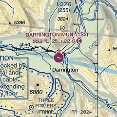
| Sectional chart |
|---|
|
| Airport distance calculator |
|---|
|
|
| Sunrise and sunset |
|---|
|
Times for 12-May-2026
| | Local
(UTC-7) | | Zulu
(UTC) |
|---|
| Morning civil twilight | | 04:55 | | 11:55 |
| Sunrise | | 05:32 | | 12:32 |
| Sunset | | 20:34 | | 03:34 |
| Evening civil twilight | | 21:11 | | 04:11 |
|
| Current date and time |
|---|
| Zulu (UTC) | 12-May-2026 10:36:05 |
|---|
| Local (UTC-7) | 12-May-2026 03:36:05 |
|---|
|
| METAR |
|---|
KAWO
23nm W | 120956Z AUTO 00000KT 10SM CLR 08/08 A2998 RMK AO2 SLP158 T00780078
|
KPAE
34nm SW | 120953Z AUTO 35003KT 10SM CLR 11/09 A2998 RMK AO2 SLP152 T01110089
|
KBVS
34nm W | 121015Z AUTO 00000KT 10SM CLR 09/09 A2998 RMK A01
|
KNRA
41nm W | 120946Z AUTO 00000KT 10SM CLR 07/06 A2999 RMK AO2 SLP098 T00720061 TSNO $
|
KNUW
42nm W | 120953Z 00000KT 10SM FEW230 08/07 A2998 RMK AO2 SLP157 T00830072 $
|
KOKH
42nm W | 120957Z AUTO 00000KT 10SM CLR 07/07 A2999 RMK AO2
|
|
| TAF |
|---|
KPAE
34nm SW | 120523Z 1206/1306 35004KT P6SM FEW250 FM122000 26005KT P6SM FEW250 FM122300 22010KT P6SM SCT250
|
KNUW
42nm W | 120700Z 1207/1307 VRB06KT 9999 FEW250 QNH2988INS BECMG 1210/1212 29008KT 9999 SCT250 QNH2978INS FM130600 24010KT 9999 -RA BKN050 QNH2980INS TX21/1300Z TN08/1212Z FS30175
|
|
| NOTAMs |
|---|
NOTAMs are issued by the DoD/FAA and will open in a separate window not controlled by AirNav.
|
|

