FAA INFORMATION EFFECTIVE 16 APRIL 2026
Location
| FAA Identifier: | 2D1 |
| Lat/Long: | 40-58-11.8947N 081-05-55.2011W
40-58.198245N 081-05.920018W
40.9699708,-81.0986670
(estimated) |
| Elevation: | 1062 ft. / 324 m (estimated) |
| Variation: | 07W (1985) |
| From city: | 3 miles N of ALLIANCE, OH |
| Time zone: | UTC -4 (UTC -5 during Standard Time) |
| Zip code: | 44601 |
Airport Operations
| Airport use: | Open to the public |
| Activation date: | 04/1947 |
| Control tower: | no |
| ARTCC: | CLEVELAND CENTER |
| FSS: | CLEVELAND FLIGHT SERVICE STATION |
| NOTAMs facility: | CLE (NOTAM-D service available) |
| Attendance: | 0800-DUSK |
| Wind indicator: | yes |
| Segmented circle: | no |
Airport Communications
| CTAF: | 122.9 |
| WX ASOS at CAK (16 nm W): | PHONE 330-227-8682 |
| WX AWOS-3 at POV (16 nm NW): | 118.675 (330-298-9353) |
| WX ASOS at AKR (17 nm W): | 126.825 (330-724-4237) |
| WX AWOS-2 at 1G3 (18 nm NW): | 119.15 (330-346-1497) |
Nearby radio navigation aids
| VOR radial/distance | | VOR name | | Freq | | Var |
|---|
| ACOr155/9.5 | | AKRON VOR/DME | | 114.40 | | 04W |
| BSVr052/20.5 | | BRIGGS VOR/DME | | 114.05 | | 04W |
| NDB name | | Hdg/Dist | | Freq | | Var | | ID |
|---|
| AKRON | | 122/14.4 | | 362 | | 07W | | AK | .- -.- |
| CASTLE | | 273/31.1 | | 272 | | 09W | | UCP | ..- -.-. .--. |
Airport Services
| Parking: | hangars and tiedowns |
| Airframe service: | NONE |
| Powerplant service: | NONE |
| Bottled oxygen: | NONE |
| Bulk oxygen: | NONE |
Runway Information
Runway 18/36
| Dimensions: | 3500 x 80 ft. / 1067 x 24 m |
| Surface: | turf, in poor condition
MINOR RUTS & HUMPS FULL LEN.
SOFT DURG SPRING & WHEN WET. |
| Runway edge markings: | CONES. |
| RUNWAY 18 | | RUNWAY 36 |
| Latitude: | 40-58.420167N | | 40-57.843500N |
| Longitude: | 081-05.922500W | | 081-05.917667W |
| Traffic pattern: | left | | left |
| Runway end identifier lights: | no | | no |
| Obstructions: | 15 ft. road, 20 ft. from runway, 125 ft. both sides of centerline, 1:1 slope to clear
OBSTN CLNC SLP 1:1 OVR +15 FT ROAD, 20 FT DIST, 125 FT L/R. | | 3 ft. crops, 40 ft. left of centerline
OBSTN CLNC SLP 0:1 OVR 3 FT CROPS, 0 FT DIST, 40 FT L. |
Runway 9/27
| Dimensions: | 2088 x 130 ft. / 636 x 40 m |
| Surface: | turf, in poor condition
MINOR RUTS & HUMPS FULL LEN.
SOFT DURG SPRING & WHEN WET. |
| Runway edge markings: | CONES. |
| RUNWAY 9 | | RUNWAY 27 |
| Latitude: | 40-58.311103N | | 40-58.308028N |
| Longitude: | 081-06.146792W | | 081-05.693030W |
| Elevation: | 1056.0 ft. | | 1067.0 ft. |
| Traffic pattern: | left | | left |
| Runway end identifier lights: | no | | no |
| Obstructions: | 25 ft. pline, 35 ft. from runway, 60 ft. both sides of centerline, 1:1 slope to clear
OBSTN CLNC SLP 1:1 OVR 25 FT FONE POLE/LINE, 35 FT DIST, 125 FT B. | | 55 ft. trees, 110 ft. left of centerline
OBSTN CLNC SLP 0:1 OVR 55 FT TREES, 0 FT DIST, 110 FT L. |
Airport Ownership and Management from official FAA records
| Ownership: | Privately-owned |
| Owner: | MELANA MUI-YING CHAN KRUECK
13822 UNION AVE NE
ALLIANCE, OH 44601-9348
Phone 330-575-2263 |
| Manager: | JAMES LEE BROGAN
5247 LIMERICK AVE NW
NORTH CANTON, OH 44720-7442
Phone 330-356-9005 |
Additional Remarks
| - | NGT OPS NA. |
| - | AEROBATIC PRACTICE AREA WI 1 NM SFC-5000 FT MSL, HRS IREG, CHECK NOTAMS. |
| - | OCNL GND LVL AEROBATIC PRACTICE. |
| - | UAS OPS IN AREA MNT CTAF. |
| - | PPR FOR WINTER OPS - CTC AMGR. |
| - | PJE ON & WI 5 NM OF ARPT SFC-FL180, CHECK CAK APCH & MNT CTAF. |
| - | DEER, BIRDS, & WILDLIFE ON & INVOF ARPT. |
| - | FOR CD CTC CLEVELAND APCH AT 216-352-2323, WHEN APCH CLSD CTC CLEVELAND ARTCC AT 440-774-0223/0490. |
Instrument Procedures
There are no published instrument procedures at 2D1.
Some nearby airports with instrument procedures:
3G6 - Tri-City Airport (6 nm SE)
38D - Salem Airpark (11 nm E)
KCAK - Akron-Canton Regional Airport (16 nm W)
KPOV - Portage County Airport (16 nm NW)
KAKR - Akron Fulton International Airport (17 nm W)
1G3 - Kent State University Airport (18 nm NW)
4G4 - Youngstown Elser Metro Airport (19 nm E)
|
|

Road maps at:
MapQuest
Bing
Google
| Aerial photo |
|---|
WARNING: Photo may not be current or correct
 Taken early June 2007
from the northwest, with 27 on the upper left and 36 on the upper right
Taken early June 2007
from the northwest, with 27 on the upper left and 36 on the upper right
Do you have a better or more recent aerial photo of Lee Field Airport that you would like to share? If so, please send us your photo.
|
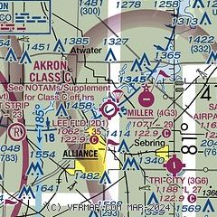
| Sectional chart |
|---|
|
| Airport distance calculator |
|---|
|
|
| Sunrise and sunset |
|---|
|
Times for 13-May-2026
| | Local
(UTC-4) | | Zulu
(UTC) |
|---|
| Morning civil twilight | | 05:39 | | 09:39 |
| Sunrise | | 06:10 | | 10:10 |
| Sunset | | 20:32 | | 00:32 |
| Evening civil twilight | | 21:03 | | 01:03 |
|
| Current date and time |
|---|
| Zulu (UTC) | 13-May-2026 20:00:59 |
|---|
| Local (UTC-4) | 13-May-2026 16:00:59 |
|---|
|
| METAR |
|---|
KPOV
16nm NW | 131935Z AUTO 33012G18KT 10SM SCT029 SCT050 14/07 A2980 RMK AO2 T01430072
|
KCAK
16nm W | 131951Z 30014G25KT 10SM BKN045 OVC065 15/08 A2979 RMK AO2 PK WND 30028/1936 SLP087 BINOVC T01500078 $
|
KAKR
17nm W | 131954Z AUTO 33013G19KT 10SM FEW038 SCT047 OVC060 14/07 A2980 RMK AO2 PK WND 25026/1856 SLP090 T01440072 $
|
KYNG
26nm NE | 131951Z 32021G27KT 10SM SCT029 BKN050 14/07 A2977 RMK AO2 PK WND 32027/1951 SLP081 T01440072 $
|
KUCP
31nm E | 131856Z AUTO 31007KT 10SM FEW014 SCT047 BKN075 16/13 A2975 RMK AO2 LTG DSNT SE AND S TSE00RAE42 SLP088 P0003 T01560128
|
|
| TAF |
|---|
KCAK
16nm W | 131728Z 1318/1418 31015G23KT P6SM BKN035 FM140000 35012KT P6SM OVC025 FM140500 33008KT P6SM -SHRA OVC015 FM140900 33010KT P6SM OVC015 FM141600 35012G22KT P6SM OVC028
|
|
| NOTAMs |
|---|
NOTAMs are issued by the DoD/FAA and will open in a separate window not controlled by AirNav.
|
|


