FAA INFORMATION EFFECTIVE 11 JUNE 2026
Location
| FAA Identifier: | 4K6 |
| Lat/Long: | 40-43-55.5800N 092-25-41.7680W
40-43.926333N 092-25.696133W
40.7321056,-92.4282689
(estimated) |
| Elevation: | 888 ft. / 270.7 m (surveyed) |
| Variation: | 02E (2000) |
| From city: | 2 miles SW of BLOOMFIELD, IA |
| Time zone: | UTC -5 (UTC -6 during Standard Time) |
| Zip code: | 52537 |
Airport Operations
| Airport use: | Open to the public |
| Activation date: | 09/1961 |
| Control tower: | no |
| ARTCC: | CHICAGO CENTER |
| FSS: | FORT DODGE FLIGHT SERVICE STATION |
| NOTAMs facility: | FOD (NOTAM-D service available) |
| Attendance: | MON-FRI 0830-1730, ALL SAT 0900-1200 |
| Wind indicator: | lighted |
| Segmented circle: | no |
| Lights: | ACTVT MIRL RY 18/36 - CTAF. |
| Beacon: | white-green (lighted land airport)
Operates sunset to sunrise. |
Airport Communications
- APCH/DEP SVC PRVDD BY CHICAGO ARTCC ON FREQS 118.15/335.575 (OTTUMWA RCAG).
Nearby radio navigation aids
| VOR radial/distance | | VOR name | | Freq | | Var |
|---|
| IRKr006/36.6 | | KIRKSVILLE VORTAC | | 114.60 | | 06E |
Airport Services
| Fuel available: | 100LL |
| Parking: | hangars and tiedowns |
| Airframe service: | MAJOR |
| Powerplant service: | MAJOR |
| Bottled oxygen: | NONE |
| Bulk oxygen: | NONE |
Runway Information
Runway 18/36
| Dimensions: | 3401 x 60 ft. / 1037 x 18 m |
| Surface: | concrete, in good condition |
| Weight bearing capacity: | | PCN 6 /R/C/W/T | | Single wheel: | 28.0 | | Double wheel: | 20.0 |
|
| Runway edge lights: | medium intensity |
| RUNWAY 18 | | RUNWAY 36 |
| Latitude: | 40-44.205800N | | 40-43.645733N |
| Longitude: | 092-25.700167W | | 092-25.693200W |
| Elevation: | 883.0 ft. | | 888.0 ft. |
| Traffic pattern: | left | | left |
| Runway heading: | 177 magnetic, 179 true | | 357 magnetic, 359 true |
| Markings: | nonprecision, in good condition | | nonprecision, in good condition |
| Visual slope indicator: | 2-light PAPI on left (3.00 degrees glide path) | | 2-light PAPI on left (3.00 degrees glide path) |
| Touchdown point: | yes, no lights | | yes, no lights |
| Obstructions: | 58 ft. tree, 801 ft. from runway, 182 ft. right of centerline, 10:1 slope to clear | | 22 ft. trees, 732 ft. from runway, 114 ft. right of centerline, 24:1 slope to clear |
Airport Ownership and Management from official FAA records
| Ownership: | Publicly-owned |
| Owner: | CITY OF BLOOMFIELD
111 W FRANKLIN ST
BLOOMFIELD, IA 52537
Phone 641-664-2260 |
| Manager: | CHARLES A. SPARGUR
MUNI ARPT 20956 230TH ST
BLOOMFIELD, IA 52537
Phone 641-664-1255
TONY |
Additional Remarks
| - | FOR SVC AFTER HRS CALL 641-208-6709. |
| - | FOR CD CTC CHICAGO ARTCC AT 630-906-8921. |
Instrument Procedures
NOTE: All procedures below are presented as PDF files. If you need a reader for these files, you should download the free Adobe Reader.NOT FOR NAVIGATION. Please procure official charts for flight.
FAA instrument procedures published for use from 11 June 2026 at 0901Z to 09 July 2026 at 0900z.
IAPs - Instrument Approach Procedures |
|---|
| RNAV (GPS) RWY 36 | |
download (183KB) |
| NOTE: Special Take-Off Minimums/Departure Procedures apply | |
download (426KB) |
Other nearby airports with instrument procedures:
03D - Memphis Memorial Airport (19 nm SE)
KTVK - Centerville Municipal Airport (22 nm W)
4C8 - Albia Municipal Airport (22 nm NW)
KOTM - Ottumwa Regional Airport (23 nm N)
KFFL - Fairfield Municipal Airport (28 nm NE)
|
|

Road maps at:
MapQuest
Bing
Google
| Aerial photo |
|---|

|
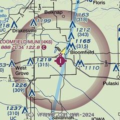
| Sectional chart |
|---|
|
| Airport distance calculator |
|---|
|
|
| Sunrise and sunset |
|---|
|
Times for 11-Jun-2026
| | Local
(UTC-5) | | Zulu
(UTC) |
|---|
| Morning civil twilight | | 05:06 | | 10:06 |
| Sunrise | | 05:39 | | 10:39 |
| Sunset | | 20:40 | | 01:40 |
| Evening civil twilight | | 21:13 | | 02:13 |
|
| Current date and time |
|---|
| Zulu (UTC) | 11-Jun-2026 21:54:55 |
|---|
| Local (UTC-5) | 11-Jun-2026 16:54:55 |
|---|
|
| METAR |
|---|
KTVK
22nm W | 112135Z AUTO 30017KT 10SM BKN019 BKN026 25/22 A2973 RMK A01
|
KOTM
22nm N | 112140Z AUTO 30011KT 10SM SCT011 BKN017 BKN045 21/19 A2968 RMK AO2 TSE2054 T02110194
|
KFFL
28nm NE | 112115Z AUTO 29011G20KT 9SM FEW024 SCT032 BKN039 21/21 A2963 RMK A01
|
KOOA
30nm N | 112135Z AUTO 31012G16KT 10SM CLR 23/20 A2969 RMK AO2 T02260201
|
KIRK
38nm S | 112123Z AUTO 09008KT 10SM TS FEW014 SCT039 BKN049 22/21 A2967 RMK AO2 LTG DSNT ALQDS RAE15 PRESFR P0006 T02170211
|
|
| TAF |
|---|
KOTM
22nm N | 111723Z 1118/1218 18013KT 6SM -SHRA BKN015 TEMPO 1118/1120 4SM -TSRA OVC006CB FM112000 27018G30KT 4SM -TSRA OVC008CB FM112200 31018G30KT P6SM BKN045 FM120200 29009KT P6SM SKC
|
|
| NOTAMs |
|---|
NOTAMs are issued by the DoD/FAA and will open in a separate window not controlled by AirNav.
|
|

