FAA INFORMATION EFFECTIVE 16 APRIL 2026
Location
| FAA Identifier: | 52F |
| Lat/Long: | 33-02-59.4410N 097-13-56.0550W
33-02.990683N 097-13.934250W
33.0498447,-97.2322375
(estimated) |
| Elevation: | 643 ft. / 196 m (estimated) |
| Variation: | 07E (1985) |
| From city: | 3 miles NW of ROANOKE, TX |
| Time zone: | UTC -5 (UTC -6 during Standard Time) |
| Zip code: | 76262 |
Airport Operations
| Airport use: | Open to the public |
| Activation date: | 12/1969 |
| Control tower: | no |
| ARTCC: | FORT WORTH CENTER |
| FSS: | FORT WORTH FLIGHT SERVICE STATION |
| NOTAMs facility: | FTW (NOTAM-D service available) |
| Attendance: | MON-SAT 0900-1700 |
| Wind indicator: | yes |
| Segmented circle: | no |
| Lights: | SS-SR |
| Beacon: | white-green (lighted land airport)
Operates sunset to sunrise. |
Airport Communications
| CTAF: | 122.9 |
| WX ASOS at AFW (6 nm SW): | PHONE 817-491-6188 |
| WX ASOS at DTO (9 nm N): | 119.325 (940-354-2971) |
| WX ASOS at DFW (13 nm SE): | PHONE 214-600-7784 |
| WX ASOS at FTW (15 nm SW): | PHONE 817-740-3346 |
Nearby radio navigation aids
| VOR radial/distance | | VOR name | | Freq | | Var |
|---|
| FUZr339/10.0 | | RANGER VORTAC | | 115.70 | | 06E |
| TTTr312/14.5 | | MAVERICK VOR/DME | | 113.10 | | 06E |
| CVEr294/19.1 | | COWBOY VOR/DME | | 116.20 | | 06E |
| NDB name | | Hdg/Dist | | Freq | | Var | | ID |
|---|
| MUFIN | | 029/11.8 | | 365 | | 08E | | FT | ..-. - |
| PINCK | | 183/14.1 | | 257 | | 04E | | DT | -.. - |
Airport Services
| Fuel available: | 100LL |
| Airframe service: | MAJOR |
| Powerplant service: | MAJOR |
| Bottled oxygen: | NONE |
| Bulk oxygen: | NONE |
Runway Information
Runway 17/35
| Dimensions: | 3500 x 40 ft. / 1067 x 12 m |
| Surface: | asphalt, in poor condition
EXTENSIVE CRACKING |
| Weight bearing capacity: | |
| Runway edge lights: | low intensity |
| RUNWAY 17 | | RUNWAY 35 |
| Traffic pattern: | left | | left |
| Displaced threshold: | 400 ft. | | 320 ft. |
| Markings: | NSTD, in good condition | | NSTD, in good condition |
| Obstructions: | 32 ft. tree, 314 ft. from runway, 125 ft. right of centerline, 3:1 slope to clear
18 FT RD 40 FT DSTC, 125 L/R. | | 50 ft. trees, 201 ft. from runway, 125 ft. right of centerline
4 FT FENCE 15 FT DSTC. |
Airport Ownership and Management from official FAA records
| Ownership: | Privately-owned |
| Owner: | HYDE-WAY, INC.
P.O. BOX 1542
ROANOKE, TX 76262
Phone 817-430-1905 |
| Manager: | BRIAN HIGGINS
132 BOEING WAY
ROANOKE, TX 76262
Phone 682-237-9039
AEROVALLEYAIRPORT@GMAIL.COM |
Additional Remarks
| - | FULL RWY AVBL FOR TKOF. |
| - | RWY MKGS, LIGHTING DO NOT COINCIDE WITH PUBLISHED VALUES. |
| - | NON-BASED FLT SCHOOLS RQR PRIOR WRITTEN PMSN. |
| - | THE FLWG OPNS ARE PROHIBITED: ULTRALIGHTS, POWERED PARACHUTES, SAILPLANES, GLIDERS, AUTO-GYROS, SKYDIVING, AG-OPERATIONS AND AIRSHIPS. |
| - | RWY 17, 18 FT RD CROSSES THRU APCH 40 FT FM RWY END, 125 FT L/R VEHICLES XNG. |
| - | TURF AREA BTW RWY AND TWYS UNSAFE FOR ACFT. |
| - | FOR CD CTC LONE STAR APCH AT 972-615-2799. |
| - | UNCONTROLLED VEHICLE TFC INVOF HGRS AND TWYS. |
Instrument Procedures
There are no published instrument procedures at 52F.
Some nearby airports with instrument procedures:
KAFW - Perot Field/Fort Worth Alliance Airport (6 nm SW)
KDTO - Denton Enterprise Airport (9 nm N)
KDFW - Dallas-Fort Worth International Airport (13 nm SE)
4T2 - Kenneth Copeland Airport (14 nm W)
KFTW - Fort Worth Meacham International Airport (15 nm SW)
KNFW - Fort Worth Naval Air Station JRB (Carswell Field) Airport (20 nm SW)
|
|

Road maps at:
MapQuest
Bing
Google
| Aerial photo |
|---|
WARNING: Photo may not be current or correct
 looking west
Do you have a better or more recent aerial photo of Aero Valley Airport that you would like to share? If so, please send us your photo.
|
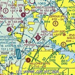
| Sectional chart |
|---|
|
| Airport distance calculator |
|---|
|
|
| Sunrise and sunset |
|---|
|
Times for 05-May-2026
| | Local
(UTC-5) | | Zulu
(UTC) |
|---|
| Morning civil twilight | | 06:12 | | 11:12 |
| Sunrise | | 06:38 | | 11:38 |
| Sunset | | 20:13 | | 01:13 |
| Evening civil twilight | | 20:39 | | 01:39 |
|
| Current date and time |
|---|
| Zulu (UTC) | 05-May-2026 18:45:16 |
|---|
| Local (UTC-5) | 05-May-2026 13:45:16 |
|---|
|
| METAR |
|---|
KAFW
7nm SW | 051753Z 20015KT 10SM FEW026 SCT180 BKN240 28/19 A2967 RMK AO2 SLP034 T02830194 10283 20211 53005 $
|
KDTO
9nm N | 051753Z 22013G22KT 10SM CLR 29/20 A2967 RMK AO2 SLP037 T02890200 10289 20206 53000
|
KDFW
14nm SE | 051753Z 21017G24KT 10SM FEW030 BKN180 BKN250 28/19 A2967 RMK AO2 SLP036 T02830189 10289 20211 53000
|
KFTW
15nm SW | 051753Z 20013G21KT 10SM CLR 28/21 A2967 RMK AO2 SLP037 T02780206 10278 20211 50001
|
|
| TAF |
|---|
KAFW
7nm SW | 051725Z 0518/0618 23015G25KT P6SM BKN250 FM052100 30012KT P6SM SCT040 BKN250 FM060000 35012KT P6SM SCT040 BKN250 FM060200 35008KT P6SM SCT120 BKN250 FM061000 36007KT P6SM BKN025 TEMPO 0612/0614 36009KT P6SM OVC015 FM061600 36008KT P6SM BKN040
|
KDFW
14nm SE | 051725Z 0518/0624 22015G25KT P6SM BKN250 FM052200 30012KT P6SM SCT040 BKN250 FM052300 34012KT P6SM VCTS SCT040CB BKN250 FM060200 35008KT P6SM SCT120 BKN250 FM060800 36007KT P6SM BKN025 TEMPO 0610/0614 36009KT P6SM OVC015 FM061600 36008KT P6SM BKN040
|
KFTW
15nm SW | 051725Z 0518/0618 22015G25KT P6SM BKN250 FM052200 30012KT P6SM SCT040 BKN250 FM052300 34012KT P6SM VCTS SCT040CB BKN250 FM060200 35008KT P6SM SCT120 BKN250 FM060800 36007KT P6SM BKN025 TEMPO 0611/0614 36009KT P6SM OVC015 FM061600 36008KT P6SM BKN040
|
|
| NOTAMs |
|---|
NOTAMs are issued by the DoD/FAA and will open in a separate window not controlled by AirNav.
|
|


