FAA INFORMATION EFFECTIVE 16 APRIL 2026
Location
| FAA Identifier: | 61D |
| Lat/Long: | 42-28-04.0476N 085-38-52.8484W
42-28.067460N 085-38.880807W
42.4677910,-85.6480134
(estimated) |
| Elevation: | 722 ft. / 220 m (estimated) |
| From city: | 2 miles N of PLAINWELL, MI |
| Time zone: | UTC -4 (UTC -5 during Standard Time) |
| Zip code: | 49080 |
Airport Operations
| Airport use: | Open to the public |
| Activation date: | 09/1946 |
| Control tower: | no |
| ARTCC: | CHICAGO CENTER |
| FSS: | LANSING FLIGHT SERVICE STATION |
| NOTAMs facility: | LAN (NOTAM-D service available) |
| Attendance: | IREG
CK FOR CONDS. |
| Wind indicator: | lighted |
| Segmented circle: | no |
| Lights: | ACTVT LIRL RWY 09/27 - 5 CLICKS CTAF. |
Airport Communications
| CTAF/UNICOM: | 122.8 |
| WX ASOS at AZO (15 nm S): | PHONE 269-459-3391 |
Nearby radio navigation aids
| VOR radial/distance | | VOR name | | Freq | | Var |
|---|
| PMMr090/20.2 | | PULLMAN VOR/DME | | 112.10 | | 00E |
| VIOr203/20.3 | | VICTORY VOR/DME | | 115.95 | | 04W |
Airport Services
| Fuel available: | 100LL
100LL:SELF SVC. |
| Parking: | tiedowns |
| Airframe service: | MAJOR |
| Powerplant service: | MAJOR |
| Bottled oxygen: | NONE |
| Bulk oxygen: | NONE |
Runway Information
Runway 9/27
| Dimensions: | 2650 x 50 ft. / 808 x 15 m |
| Surface: | asphalt, in poor condition
EXTSV CRACKING & RAVELING. |
| Runway edge lights: | low intensity |
| RUNWAY 9 | | RUNWAY 27 |
| Latitude: | 42-28.048050N | | 42-28.053117N |
| Longitude: | 085-39.123300W | | 085-38.534017W |
| Elevation: | 721.1 ft. | | 721.2 ft. |
| Traffic pattern: | left | | left |
| Runway heading: | 089 true | | 269 true |
| Displaced threshold: | 381 ft. | | 395 ft. |
| Markings: | basic, in fair condition | | basic, in fair condition |
| Runway end identifier lights: | no | | no |
| Obstructions: | 17 ft. road, 200 ft. from runway, 125 ft. left and right of centerline, 1:1 slope to clear
4 FT FENCE, 50 FT DIST; 17 FT ROAD, 140 FT DIST. | | 55 ft. trees, 201 ft. from runway, 1:1 slope to clear
6 FT FENCE, 62 FT DIST; 15 FT ROAD, 100 FT DIST; 55 FT TREE, 155 FT DIST. |
Runway 1/19
| Dimensions: | 2550 x 100 ft. / 777 x 30 m |
| Surface: | turf, in good condition |
| Runway edge markings: | RWY & DTHR MKD WITH YELLOW CONES. |
| RUNWAY 1 | | RUNWAY 19 |
| Latitude: | 42-27.876667N | | 42-28.293333N |
| Longitude: | 085-38.970000W | | 085-38.900000W |
| Elevation: | 722.0 ft. | | 722.0 ft. |
| Traffic pattern: | left | | left |
| Runway heading: | 007 true | | 187 true |
| Displaced threshold: | 400 ft. | | no |
| Runway end identifier lights: | no | | no |
| Obstructions: | 15 ft. road, 20 ft. from runway, 50 ft. right of centerline, 1:1 slope to clear
APCH SLP 19:1 TO DTHR OVR 60 FT TREE, 1150 FT DIST, 10 FT L. | | 74 ft. trees, 120 ft. from runway, 50 ft. right of centerline, 1:1 slope to clear
APCH SLP 14:1 TO DTHR OVR 60 FT TREE, 854 FT DIST, 110 FT R. |
Airport Ownership and Management from official FAA records
| Ownership: | Publicly-owned |
| Owner: | CITY OF PLAINWELL
211 N MAIN ST
PLAINWELL, MI 49080-1370
Phone 269-685-6821 |
| Manager: | VIRGIL WILLIAMS
132 COUNTRY CLUB BLVD
PLAINWELL, MI 49080-9120
Phone 269-492-5022 |
Additional Remarks
| - | FOR FLD CONDS CALL AMGR. |
| - | FOR CD CTC GREAT LAKES APCH AT 269-459-3344, WHEN APCH CLSD CTC CHICAGO ARTCC AT 630-906-8921. |
| - | RWY 19 DTHR 1350 FT, EXTDS BYD RWY MIDPT. |
Instrument Procedures
There are no published instrument procedures at 61D.
Some nearby airports with instrument procedures:
35D - Padgham Field Airport (9 nm NW)
KAZO - Kalamazoo/Battle Creek International Airport (15 nm S)
9D9 - Hastings Airport (18 nm NE)
KBTL - Battle Creek Executive Airport at Kellogg Field (20 nm SE)
Z98 - Ottawa Executive Airport (24 nm NW)
|
|

Road maps at:
MapQuest
Bing
Google
| Aerial photo |
|---|
WARNING: Photo may not be current or correct

Do you have a better or more recent aerial photo of Virgil L Williams Plainwell Municipal Airport that you would like to share? If so, please send us your photo.
|
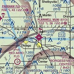
| Sectional chart |
|---|
|
| Airport distance calculator |
|---|
|
|
| Sunrise and sunset |
|---|
|
Times for 06-May-2026
| | Local
(UTC-4) | | Zulu
(UTC) |
|---|
| Morning civil twilight | | 06:01 | | 10:01 |
| Sunrise | | 06:32 | | 10:32 |
| Sunset | | 20:46 | | 00:46 |
| Evening civil twilight | | 21:18 | | 01:18 |
|
| Current date and time |
|---|
| Zulu (UTC) | 06-May-2026 15:10:20 |
|---|
| Local (UTC-4) | 06-May-2026 11:10:20 |
|---|
|
| METAR |
|---|
KAZO
15nm S | 061453Z VRB05KT 10SM CLR 09/M03 A2993 RMK AO2 SLP140 T00941033 51016
|
KBTL
20nm SE | 061453Z VRB05KT 10SM CLR 10/M04 A2992 RMK AO2 SLP135 T01001044 51015
|
KGRR
26nm N | 061453Z VRB04KT 10SM SCT120 BKN250 10/M03 A2992 RMK AO2 SLP135 T01001028 51013
|
KBIV
26nm NW | 061453Z AUTO VRB03KT 10SM CLR 09/M03 A2994 RMK AO2 SLP141 T00941033 53013
|
KLWA
28nm W | 061455Z AUTO VRB05KT 10SM CLR 10/M03 A2994 RMK AO2
|
|
| TAF |
|---|
KAZO
15nm S | 061140Z 0612/0712 32006KT P6SM SCT240 FM061800 29011G21KT P6SM SCT060 BKN140 FM062300 30009KT P6SM SCT060 BKN120 FM070300 00000KT P6SM SKC
|
|
| NOTAMs |
|---|
NOTAMs are issued by the DoD/FAA and will open in a separate window not controlled by AirNav.
|
|

