FAA INFORMATION EFFECTIVE 14 MAY 2026
Location
| FAA Identifier: | APF |
| Lat/Long: | 26-09-08.7869N 081-46-32.3011W
26-09.146448N 081-46.538352W
26.1524408,-81.7756392
(estimated) |
| Elevation: | 8.3 ft. / 2.5 m (surveyed) |
| Variation: | 03W (1995) |
| From city: | 2 miles NE of NAPLES, FL |
| Time zone: | UTC -4 (UTC -5 during Standard Time) |
| Zip code: | 34104 |
Airport Operations
| Airport use: | Open to the public |
| Activation date: | 07/1944 |
| Control tower: | yes |
| ARTCC: | MIAMI CENTER |
| FSS: | MIAMI FLIGHT SERVICE STATION |
| NOTAMs facility: | APF (NOTAM-D service available) |
| Attendance: | 0600-2200 |
| Wind indicator: | lighted |
| Segmented circle: | yes |
| Lights: | WHEN ATCT CLSD ACTVT REIL RWY 05, 14, 23 & 32; PAPI RWY 14 & 32; MIRL RWY 05/23 & 14/32 - CTAF. |
| Beacon: | white-green (lighted land airport)
Operates sunset to sunrise. |
| Fire and rescue: | ARFF index A |
| International operations: | US CUSTOMS SVC MON-SUN 1530-2400Z PPR - 239-430-9321. |
Airport Communications
| CTAF: | 128.5 |
| ATIS: | 134.225 |
| WX ASOS: | 134.225 (239-643-9886) |
| NAPLES GROUND: | 121.6 [0600-2200] |
| NAPLES TOWER: | 128.5 [0600-2200] |
| FORT MYERS APPROACH: | 119.75 ;WEST 124.125 ;EAST |
| FORT MYERS DEPARTURE: | 119.75 ;WEST 124.125 ;EAST |
| CLEARANCE DELIVERY: | 124.125 ;WHEN TWR CLSD 118.0 |
| CSHEL DP: | 119.75 ;RWY 23, 32 124.125 ;RWY 05, 14 |
| NAPLES DP: | 119.75 ;RWY 23, 32 124.125 ;RWY 05, 14 |
| PIKKR STAR: | 127.05 ;5000 FT & BLO 134.425 ;6000 FT & ABV |
| SHFTY STAR: | 126.8 |
| ZEILR STAR: | 134.425 |
| WX AWOS-3PT at MKY (11 nm SE): | 120.075 (239-394-8187) |
- FOR FBO SVC CTC NAPLES AVN - 128.825.
- APCH/DEP SVC PRVDD BY MIAMI ARTCC ON FREQS 134.75/322.5 (FORT MYERS RCAG) WHEN FORT MYERS APCH CTL CLSD.
- WHEN ATCT CLSD CLNC DEL 124.125 MONITORED BY FORT MYERS APCH CTL.
Nearby radio navigation aids
| VOR radial/distance | | VOR name | | Freq | | Var |
|---|
| RSWr182/22.6 | | LEE COUNTY VORTAC | | 114.15 | | 02W |
Airport Services
| Fuel available: | 100LL JET-A JET-A+ UL94 |
| Parking: | hangars and tiedowns |
| Airframe service: | MAJOR |
| Powerplant service: | MAJOR |
| Bottled oxygen: | HIGH/LOW |
| Bulk oxygen: | NONE |
Runway Information
Runway 5/23
| Dimensions: | 6600 x 150 ft. / 2012 x 46 m |
| Surface: | asphalt/grooved, in fair condition |
| Weight bearing capacity: | |
| Runway edge lights: | medium intensity |
| RUNWAY 5 | | RUNWAY 23 |
| Latitude: | 26-08.772662N | | 26-09.553235N |
| Longitude: | 081-46.948688W | | 081-46.106653W |
| Elevation: | 6.1 ft. | | 6.2 ft. |
| Traffic pattern: | right | | left |
| Runway heading: | 047 magnetic, 044 true | | 227 magnetic, 224 true |
| Displaced threshold: | 800 ft. | | 799 ft. |
| Declared distances: | TORA:5800 TODA:5800 ASDA:5800 LDA:5000 | | TORA:5800 TODA:5800 ASDA:5800 LDA:5000 |
| Markings: | nonprecision, in good condition | | nonprecision, in good condition |
| Visual slope indicator: | 4-light PAPI on right (3.50 degrees glide path) | | 4-light PAPI on left (3.50 degrees glide path) |
| Runway end identifier lights: | yes | | yes |
| Touchdown point: | yes, no lights | | yes, no lights |
| Obstructions: | 15 ft. road, lighted, 385 ft. from runway, 250 ft. right of centerline, 12:1 slope to clear
RWY 05 APCH SLOPE 50:1 TO DSPLCD THR. | | 8 ft. fence, lighted, 215 ft. from runway, 250 ft. right of centerline, 2:1 slope to clear
RWY 23 APCH SLOPE 47:1 TO DSPLCD THR. |
Runway 14/32
| Dimensions: | 5001 x 100 ft. / 1524 x 30 m |
| Surface: | asphalt/grooved, in good condition |
| Weight bearing capacity: | | Single wheel: | 75.0 | | Double wheel: | 75.0 |
|
| Runway edge lights: | medium intensity |
| RUNWAY 14 | | RUNWAY 32 |
| Latitude: | 26-09.457118N | | 26-08.881373N |
| Longitude: | 081-46.815245W | | 081-46.159783W |
| Elevation: | 6.2 ft. | | 6.9 ft. |
| Traffic pattern: | right | | left |
| Runway heading: | 137 magnetic, 134 true | | 317 magnetic, 314 true |
| Displaced threshold: | 128 ft. | | 451 ft. |
| Declared distances: | TORA:5001 TODA:5001 ASDA:4550 LDA:4422 | | TORA:5001 TODA:5001 ASDA:4873 LDA:4422 |
| Markings: | nonprecision, in good condition | | nonprecision, in good condition |
| Visual slope indicator: | 4-light PAPI on left (3.50 degrees glide path) | | 4-light PAPI on left (3.50 degrees glide path) |
| Runway end identifier lights: | yes | | yes |
| Touchdown point: | yes, no lights | | yes, no lights |
| Obstructions: | 47 ft. trees, 1155 ft. from runway, 240 ft. left of centerline, 20:1 slope to clear | | 44 ft. trees, 1275 ft. from runway, 165 ft. right of centerline, 24:1 slope to clear |
Runway NE/SW
| Dimensions: | 1850 x 100 ft. / 564 x 30 m |
| Surface: | turf, in good condition |
| Runway edge markings: | RWY NE/SW MKD WITH PAVERS & PVC PIPES. |
| RUNWAY NE | | RUNWAY SW |
| Latitude: | 26-08.916522N | | 26-09.135385N |
| Longitude: | 081-46.831910W | | 081-46.595862W |
| Elevation: | 4.6 ft. | | 4.9 ft. |
| Traffic pattern: | left | | left |
| Runway heading: | 047 magnetic, 044 true | | 227 magnetic, 224 true |
| Markings: | NSTD, in good condition | | NSTD, in good condition |
| Touchdown point: | yes, no lights | | yes, no lights |
Airport Ownership and Management from official FAA records
| Ownership: | Publicly-owned |
| Owner: | CITY OF NAPLES APT AUTH
160 AVIATION DR NORTH
NAPLES, FL 34104
Phone 239-643-0733 |
| Manager: | CHRISTOPHER A. ROZANSKY
160 AVIATION DR NORTH
NAPLES, FL 34104
Phone 239-643-0733 |
Additional Remarks
| A39-05/23 | PCR VALUE: 210/F/B/X/T |
| A39-14/32 | PCR VALUE: 320/F/B/X/T |
| - | EXTRMY NOISE SENSITIVE AREA; USE NOISE ABATEMENT PROCS. |
| - | RUNUPS NA 2200 - 0700; TWY A RUNUP PADS FOR RWY 5/23 PISTON ACFT ONLY; JET ACFT RUNUP AREA TWY C BTW TWY C3 & TWY D PPR - ATCT . |
| - | RWY 23 DSGND CALM WIND RWY FOR ARRS 2200-0600. RWY 5 DSGND CALM WIND RWY FOR DEPS 2200-0600. |
| - | FULL SVC FUEL NOT AVBL DLY 0130-1030Z. |
| - | APF GA APN CTN OBST LGT POLES. |
| - | WX MOD ACFT NOTIFY OPS 24 HRS PRIOR TO ARR 239-564-1692 |
| - | CLSD TO ACFT EXCEEDING 75000 LBS MAX GWT DUAL GEAR INDCD ON ACFT OPRG CERT ISSUED BY MANUFACTURER. |
| - | TWY C FM C-1 TO ER RWY 32 NOT VISIBLE FM ATCT. |
| - | VOLUNTARY RESTRICTIONS EXIST FOR ALL ACFT OPS 2200-0700. |
| - | FOR CD IF UNA TO CTC ON FSS FREQ, CTC FT MYERS APCH AT 239-416-1026, WHEN APCH CLSD CTC MIAMI ARTCC AT 305-716-1731. |
Instrument Procedures
NOTE: All procedures below are presented as PDF files. If you need a reader for these files, you should download the free Adobe Reader.NOT FOR NAVIGATION. Please procure official charts for flight.
FAA instrument procedures published for use from 14 May 2026 at 0901Z to 11 June 2026 at 0900Z.
STARs - Standard Terminal Arrivals |
|---|
| PIKKR SEVEN (RNAV) | |
download (204KB) |
| SHFTY SIX (RNAV) | |
2 pages:
[1] [2] (477KB) |
| ZEILR SIX | |
download (118KB) |
IAPs - Instrument Approach Procedures |
|---|
| RNAV (RNP) Z RWY 05 | |
download (203KB) |
| RNAV (RNP) Z RWY 23 | |
download (181KB) |
| RNAV (GPS) RWY 14 | |
download (233KB) |
| RNAV (GPS) RWY 32 | |
download (237KB) |
| RNAV (GPS) Y RWY 05 | |
download (228KB) |
| RNAV (GPS) Y RWY 23 | |
download (221KB) |
| NOTE: Special Alternate Minimums apply | |
download (146KB) |
Departure Procedures |
|---|
| CSHEL EIGHT (RNAV) | |
download (255KB) |
| NAPLES SIX | |
download (167KB) |
| NOTE: Special Take-Off Minimums/Departure Procedures apply | |
download (162KB) |
Other nearby airports with instrument procedures:
KMKY - Marco Island Executive Airport (11 nm SE)
KRSW - Southwest Florida International Airport (23 nm N)
KIMM - Immokalee Regional Airport (26 nm NE)
KFMY - Page Field Airport (26 nm N)
X14 - La Belle Municipal Airport (40 nm NE)
|
|

Road maps at:
MapQuest
Bing
Google
| Aerial photo |
|---|
WARNING: Photo may not be current or correct
 Photo courtesy of Dynamaint
Photo taken 10-Nov-2016
looking northwest
Photo courtesy of Dynamaint
Photo taken 10-Nov-2016
looking northwest
Do you have a better or more recent aerial photo of Naples Municipal Airport that you would like to share? If so, please send us your photo.
|
| Sectional chart |
|---|
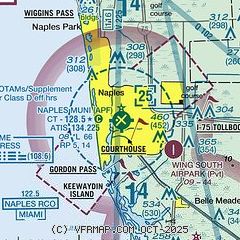
|
CAUTION: Diagram may not be current
 Download PDF
of official airport diagram from the FAA
| Airport distance calculator |
|---|
|
|
| Sunrise and sunset |
|---|
|
Times for 20-May-2026
| | Local
(UTC-4) | | Zulu
(UTC) |
|---|
| Morning civil twilight | | 06:14 | | 10:14 |
| Sunrise | | 06:39 | | 10:39 |
| Sunset | | 20:08 | | 00:08 |
| Evening civil twilight | | 20:33 | | 00:33 |
|
| Current date and time |
|---|
| Zulu (UTC) | 20-May-2026 15:05:08 |
|---|
| Local (UTC-4) | 20-May-2026 11:05:08 |
|---|
|
| METAR |
|---|
| KAPF | 201453Z 12011KT 10SM FEW030 FEW037 31/23 A3006 RMK AO2 SLP178 T03060228 58001
|
KMKY
11nm SE | 201456Z AUTO 09007KT 050V140 10SM FEW027 BKN035 30/22 A3007 RMK AO2 SLP182 6//// T03000217 58001 PNO $
|
|
| TAF |
|---|
| KAPF | 201120Z 2012/2112 10010KT P6SM SCT100 FM201500 12008KT P6SM SCT025 BKN050 FM201800 21010KT P6SM VCTS SCT025CB BKN050 FM210200 VRB04KT P6SM SCT025 SCT250
|
|
| NOTAMs |
|---|
NOTAMs are issued by the DoD/FAA and will open in a separate window not controlled by AirNav.
|
|


