FAA INFORMATION EFFECTIVE 09 JULY 2026
Location
| FAA Identifier: | ATL |
| Lat/Long: | 33-38-12.1186N 084-25-40.3104W
33-38.201977N 084-25.671840W
33.6366996,-84.4278640
(estimated) |
| Elevation: | 1026.2 ft. / 312.8 m (surveyed) |
| Variation: | 05W (2015) |
| From city: | 7 miles S of ATLANTA, GA |
| Time zone: | UTC -4 (UTC -5 during Standard Time) |
| Zip code: | 30337 |
Airport Operations
| Airport use: | Open to the public |
| Activation date: | 09/1942 |
| Control tower: | yes |
| ARTCC: | ATLANTA CENTER |
| FSS: | MACON FLIGHT SERVICE STATION |
| NOTAMs facility: | ATL (NOTAM-D service available) |
| Attendance: | CONTINUOUS |
| Wind indicator: | yes |
| Segmented circle: | no |
| Beacon: | white-green (lighted land airport)
ROTG BCN LCTD S OF TWY R7, N OF TWY SJ2 NR FIRE STATION. Operates sunset to sunrise. |
| Landing fee: | yes |
| Fire and rescue: | ARFF index E |
| International operations: | customs landing rights airport |
Airport Communications
| UNICOM: | 122.95 |
| WX ASOS: | PHONE 404-559-5166 |
| ATLANTA GROUND: | 121.65 ;RWY 10/28 121.75 ;RWY 09L/27R, 09R/27L 121.9 ;RWY 08L/26R, 08R/26L 254.4 134.725 |
| ATLANTA TOWER: | 119.1 ;RWY 08L/26R 119.3 ;RWY 09R/27L 119.5 ;RWY 10/28 123.85 ;RWY 09L/27R 125.325 ;RWY 08R/26L 254.4 |
| ATLANTA APPROACH: | 128.0 134.725 ;090-269 |
| ATLANTA DEPARTURE: | 121.225 ;RWY 10/28 125.65 ;RWY 09L/27R, 09R/27L 133.475 ;RWY 08L/26R, 08R/26L |
| CLEARANCE DELIVERY: | 118.1 |
| ATLANTA DP: | 121.225 ;RWY 10/28 125.65 ;RWY 09L/27R, 09R/27L 133.475 ;RWY 08L/26R, 08R/26L |
| BANNG DP: | 121.225 ;RWY 10/28 125.65 ;RWY 09L/27R, 09R/27L 133.475 ;RWY 08L/26R, 08R/26L |
| BUKHD STAR: | 121.0 |
| CHPPR STAR: | 128.0 |
| CUTTN DP: | 121.225 ;RWY 10/28 125.65 ;RWY 09L/27R, 09R/27L 133.475 ;RWY 08L/26R, 08R/26L |
| D-ATIS: | 119.65 ;ARR 125.55 ;DEP |
| DEHAN STAR: | 126.975 |
| EMERG: | 121.5 243.0 |
| FINAL: | 124.6 ;RWY 09L, 09R, 27L, 27R 127.25 ;RWY 08L, 08R, 26L, 26R 135.375 ;RWY 10, 28 |
| GAIRY DP: | 121.225 ;RWY 10/28 125.65 ;RWY 09L/27R, 09R/27L 133.475 ;RWY 08L/26R, 08R/26L |
| GLAVN STAR: | 128.0 |
| HAALO DP: | 121.225 ;RWY 10/28 125.65 ;RWY 09L/27R, 09R/27L 133.475 ;RWY 08L/26R, 08R/26L |
| HOBTT STAR: | 134.725 |
| IC: | 134.725 ;090-269 |
| JACCC DP: | 121.225 ;RWY 10/28 125.65 ;RWY 09L/27R, 09R/27L 133.475 ;RWY 08L/26R, 08R/26L |
| JJEDI STAR: | 134.725 |
| KAJIN DP: | 121.225 ;RWY 10/28 125.65 ;RWY 09L/27R, 09R/27L 133.475 ;RWY 08L/26R, 08R/26L |
| NASSA DP: | 121.225 ;RWY 10/28 125.65 ;RWY 09L/27R, 09R/27L 133.475 ;RWY 08L/26R, 08R/26L |
| ONDRE STAR: | 128.525 |
| OZZZI STAR: | 128.525 |
| PADGT DP: | 121.225 ;RWY 10/28 125.65 ;RWY 09L/27R, 09R/27L 133.475 ;RWY 08L/26R, 08R/26L |
| PENCL DP: | 121.225 ;RWY 10/28 125.65 ;RWY 09L/27R, 09R/27L 133.475 ;RWY 08L/26R, 08R/26L |
| PHIIL DP: | 121.225 ;RWY 10/28 125.65 ;RWY 09L/27R, 09R/27L 133.475 ;RWY 08L/26R, 08R/26L |
| PLMMR DP: | 121.225 ;RWY 10/28 125.65 ;RWY 09L/27R, 09R/27L 133.475 ;RWY 08L/26R, 08R/26L |
| POUNC DP: | 121.225 ;RWY 10/28 125.65 ;RWY 09L/27R, 09R/27L 133.475 ;RWY 08L/26R, 08R/26L |
| PRM: | 132.55 ;RWY 09L/27R, 09R/27L 133.425 ;RWY 10/28 |
| RAMP CTL: | 128.975 ;RAMP 8 129.25 ;RAMP 6N SNOW AND ICE 129.25 ;RAMP 7 SNOW AND ICE 129.275 ;RAMP 3 129.375 ;RAMP 5 129.4 ;RAMP 33 SNOW AND ICE 130.075 ;RAMP 4 130.775 ;RAMP 20 SNOW AND ICE 131.375 ;NON MOVEMENT AREA 131.375 ;RAMP 6 131.375 ;RAMP 6S SNOW AND ICE 131.45 ;RAMP 1 131.85 ;RAMP 2 131.875 ;RAMP 9 |
| SITTH STAR: | 134.725 |
| SMKEY DP: | 121.225 ;RWY 10/28 125.65 ;RWY 09L/27R, 09R/27L 133.475 ;RWY 08L/26R, 08R/26L |
| SMLTZ DP: | 121.225 ;RWY 10/28 125.65 ;RWY 09L/27R, 09R/27L 133.475 ;RWY 08L/26R, 08R/26L |
| STAR: | 134.725 |
| VARNM DP: | 121.225 ;RWY 10/28 125.65 ;RWY 09L/27R, 09R/27L 133.475 ;RWY 08L/26R, 08R/26L |
| VRSTY DP: | 121.225 ;RWY 10/28 125.65 ;RWY 09L/27R, 09R/27L 133.475 ;RWY 08L/26R, 08R/26L |
| ZELAN DP: | 121.225 ;RWY 10/28 125.65 ;RWY 09L/27R, 09R/27L 133.475 ;RWY 08L/26R, 08R/26L |
| WX ASOS at FTY (10 nm NW): | PHONE 404-696-5660 |
| WX AWOS-3 at HMP (16 nm S): | 124.825 (770-707-1719) |
| WX ASOS at PDK (16 nm NE): | 128.4 (770-457-1691) |
| WX ASOS at FFC (18 nm SW): | 118.525 (770-487-1610) |
- THE FOLLOWING FREQS USED FOR RAMP SVC: RAMP NR 1 131.45; RAMP NR 2 131.85; RAMP NR 3 129.27; RAMP NR 4 129.37; RAMP NR 5 131.25.
- ARR ATIS PHONE 404-763-7988.
- ASDE-X IN USE. OPERATE TRANSPONDERS WITH ALTITUDE REPORTING MODE AND ADS-B (IF EQUIPPED) ENABLED ON ALL AIRPORT SURFACES.
Nearby radio navigation aids
| NDB name | | Hdg/Dist | | Freq | | Var | | ID |
|---|
| PECAT | | 013/20.4 | | 316 | | 05W | | FFC | ..-. ..-. -.-. |
| COWETA COUNTY | | 035/26.9 | | 234 | | 03W | | EQQ | . --.- --.- |
| CARROLLTON | | 087/35.4 | | 278 | | 04W | | GPQ | --. .--. --.- |
Airport Services
| Fuel available: | 100 100LL JET-A |
| Parking: | hangars |
| Airframe service: | MAJOR |
| Powerplant service: | MAJOR |
| Bottled oxygen: | HIGH/LOW |
| Bulk oxygen: | HIGH/LOW |
Runway Information
Runway 9L/27R
| Dimensions: | 12390 x 150 ft. / 3776 x 46 m |
| Surface: | concrete/grooved, in good condition |
| Weight bearing capacity: | | Single wheel: | 120.0 | | Double wheel: | 200.0 | | Double tandem: | 360.0 |
|
| Runway edge lights: | high intensity |
| RUNWAY 9L | | RUNWAY 27R |
| Latitude: | 33-38.082267N | | 33-38.082150N |
| Longitude: | 084-26.878012W | | 084-24.435967W |
| Elevation: | 1018.7 ft. | | 977.2 ft. |
| Traffic pattern: | left | | left |
| Runway heading: | 095 magnetic, 090 true | | 275 magnetic, 270 true |
| Displaced threshold: | no | | 500 ft. |
| Declared distances: | TORA:12390 TODA:12390 ASDA:11730 LDA:11730 | | TORA:12390 TODA:12390 ASDA:12390 LDA:11890 |
| Markings: | precision, in good condition | | precision, in good condition |
| Visual slope indicator: | 4-light PAPI on right (3.00 degrees glide path) | | 4-light PAPI on right (3.00 degrees glide path) |
| RVR equipment: | touchdown, midfield, rollout | | touchdown, midfield, rollout |
| Approach lights: | | | MALS: 1,400 foot medium intensity approach lighting system |
| Centerline lights: | yes | | yes |
| Touchdown point: | yes, no lights | | yes, no lights |
| Instrument approach: | ILS/DME | | ILS |
| Obstructions: | 110 ft. tank, 3937 ft. from runway, 214 ft. left of centerline, 33:1 slope to clear
CONCRETE HOPPER | | 62 ft. tree, 2527 ft. from runway, 388 ft. right of centerline, 37:1 slope to clear |
Runway 8R/26L
| Dimensions: | 9999 x 150 ft. / 3048 x 46 m |
| Surface: | concrete/grooved, in good condition |
| Weight bearing capacity: | | Single wheel: | 120.0 | | Double wheel: | 200.0 | | Double tandem: | 360.0 |
|
| Runway edge lights: | high intensity |
| RUNWAY 8R | | RUNWAY 26L |
| Latitude: | 33-38.807200N | | 33-38.807687N |
| Longitude: | 084-26.301725W | | 084-24.330522W |
| Elevation: | 1023.7 ft. | | 995.4 ft. |
| Traffic pattern: | left | | left |
| Runway heading: | 095 magnetic, 090 true | | 275 magnetic, 270 true |
| Declared distances: | TORA:9999 TODA:10999 ASDA:9999 LDA:9999 | | TORA:9999 TODA:9999 ASDA:9999 LDA:9999 |
| Markings: | precision, in good condition | | precision, in good condition |
| Visual slope indicator: | 4-light PAPI on left (3.00 degrees glide path) | | 4-light PAPI on left (3.00 degrees glide path)
PAPI RWY 26L UNUSBL BYD 7 DEG LEFT AND RIGHT OF RCL. |
| RVR equipment: | touchdown, midfield, rollout | | touchdown, midfield, rollout |
| Approach lights: | | | MALSR: 1,400 foot medium intensity approach lighting system with runway alignment indicator lights |
| Centerline lights: | yes | | yes |
| Touchdown point: | yes, no lights | | yes, no lights |
| Instrument approach: | ILS/DME | | ILS/DME |
| Obstructions: | 94 ft. tree, 2832 ft. from runway, 557 ft. right of centerline, 28:1 slope to clear | | 26 ft. tree, 517 ft. from runway, 496 ft. right of centerline, 12:1 slope to clear |
Runway 8L/26R
| Dimensions: | 9000 x 150 ft. / 2743 x 46 m |
| Surface: | concrete/grooved, in good condition |
| Weight bearing capacity: | | Single wheel: | 120.0 | | Double wheel: | 200.0 | | Double tandem: | 360.0 |
|
| Runway edge lights: | high intensity |
| RUNWAY 8L | | RUNWAY 26R |
| Latitude: | 33-38.972063N | | 33-38.972525N |
| Longitude: | 084-26.341538W | | 084-24.567235W |
| Elevation: | 1014.6 ft. | | 990.0 ft. |
| Traffic pattern: | left | | left |
| Runway heading: | 095 magnetic, 090 true | | 275 magnetic, 270 true |
| Declared distances: | TORA:9000 TODA:9000 ASDA:8800 LDA:8800 | | TORA:9000 TODA:9000 ASDA:8500 LDA:8500 |
| Markings: | precision, in good condition | | precision, in good condition |
| Visual slope indicator: | 4-light PAPI on left (3.00 degrees glide path) | | 4-light PAPI on left (3.00 degrees glide path)
PAPI RWY 26R UNUSBL BYD 6 DEG LEFT AND 7 DEG RIGHT OF RCL. |
| RVR equipment: | touchdown, midfield, rollout | | touchdown, midfield, rollout |
| Approach lights: | ALSF2: standard 2,400 foot high intensity approach lighting system with centerline sequenced flashers (category II or III) | | MALSR: 1,400 foot medium intensity approach lighting system with runway alignment indicator lights |
| Centerline lights: | yes | | yes |
| Touchdown point: | yes, lighted | | yes, lighted |
| Instrument approach: | ILS/DME | | ILS/DME |
| Obstructions: | 116 ft. tree, 3604 ft. from runway, 661 ft. left of centerline, 29:1 slope to clear | | 45 ft. tree, 940 ft. from runway, 581 ft. right of centerline, 16:1 slope to clear |
Runway 9R/27L
| Dimensions: | 9000 x 150 ft. / 2743 x 46 m |
| Surface: | concrete/grooved, in fair condition |
| Weight bearing capacity: | | Single wheel: | 120.0 | | Double wheel: | 200.0 | | Double tandem: | 360.0 |
|
| Runway edge lights: | high intensity |
| RUNWAY 9R | | RUNWAY 27L |
| Latitude: | 33-37.908803N | | 33-37.909415N |
| Longitude: | 084-26.877947W | | 084-25.104050W |
| Elevation: | 1026.1 ft. | | 984.7 ft. |
| Traffic pattern: | left | | left |
| Runway heading: | 095 magnetic, 090 true | | 275 magnetic, 270 true |
| Declared distances: | TORA:9000 TODA:9000 ASDA:9000 LDA:9000 | | TORA:9000 TODA:9000 ASDA:8865 LDA:8865 |
| Markings: | precision, in good condition | | precision, in good condition |
| Visual slope indicator: | 4-light PAPI on left (3.00 degrees glide path) | | 4-light PAPI on right (3.00 degrees glide path) |
| RVR equipment: | touchdown, midfield, rollout | | touchdown, midfield, rollout |
| Approach lights: | ALSF2: standard 2,400 foot high intensity approach lighting system with centerline sequenced flashers (category II or III) | | ALSF2: standard 2,400 foot high intensity approach lighting system with centerline sequenced flashers (category II or III) |
| Centerline lights: | yes | | yes |
| Touchdown point: | yes, lighted | | yes, lighted |
| Instrument approach: | ILS/DME | | ILS/DME |
| Obstructions: | 136 ft. pole, 4497 ft. from runway, 1012 ft. right of centerline, 31:1 slope to clear | | 56 ft. tree, 2259 ft. from runway, 618 ft. left of centerline, 36:1 slope to clear |
Runway 10/28
| Dimensions: | 9000 x 150 ft. / 2743 x 46 m |
| Surface: | concrete/grooved, in good condition |
| Weight bearing capacity: | | Single wheel: | 75.0 | | Double wheel: | 209.0 | | Double tandem: | 600.0 | | Dual double tandem: | 900.0 |
|
| Runway edge lights: | high intensity |
| RUNWAY 10 | | RUNWAY 28 |
| Latitude: | 33-37.216347N | | 33-37.217125N |
| Longitude: | 084-26.872623W | | 084-25.098930W |
| Elevation: | 1000.3 ft. | | 997.5 ft. |
| Traffic pattern: | right | | left |
| Runway heading: | 095 magnetic, 090 true | | 275 magnetic, 270 true |
| Declared distances: | TORA:9000 TODA:9000 ASDA:9000 LDA:9000 | | TORA:9000 TODA:9000 ASDA:9000 LDA:9000 |
| Markings: | precision, in good condition | | precision, in good condition |
| Visual slope indicator: | 4-light PAPI on right (3.00 degrees glide path) | | 4-light PAPI on right (3.00 degrees glide path) |
| RVR equipment: | touchdown, midfield, rollout | | touchdown, midfield, rollout |
| Approach lights: | ALSF2: standard 2,400 foot high intensity approach lighting system with centerline sequenced flashers (category II or III) | | ALSF2: standard 2,400 foot high intensity approach lighting system with centerline sequenced flashers (category II or III) |
| Centerline lights: | yes | | yes |
| Touchdown point: | yes, lighted | | yes, lighted |
| Instrument approach: | ILS/DME | | ILS/DME |
| Obstructions: | 84 ft. tree, 2820 ft. from runway, 796 ft. right of centerline, 31:1 slope to clear | | 136 ft. tower, lighted, 4240 ft. from runway, 410 ft. right of centerline, 30:1 slope to clear |
Airport Ownership and Management from official FAA records
| Ownership: | Publicly-owned |
| Owner: | CITY OF ATLANTA
CITY HALL
ATLANTA, GA 30303
Phone 404-330-6000 |
| Manager: | RICKY SMITH
PO BOX 20509
ATLANTA, GA 30320
Phone 404-530-6600 |
Additional Remarks
| A39-09R/27L | PCR VALUE: 1068/R/C/W/T |
| A39-09L/27R | PCR VALUE: 1336/R/C/W/T |
| A39-08L/26R | PCR VALUE: 1437/R/D/W/T |
| A39-10/28 | PCR VALUE: 1378/R/C/W/T |
| A39-08R/26L | PCR VALUE: 1307/R/C/W/T |
| - | ALL RWYS, TOUCH AND GO OPERATIONS, LOW APPROACHES, AND PRACTICE INSTRUMENT APPROACHES NOT PERMITTED. |
| - | ACFT WITH A WINGSPAN OF GREATER THAN 214FT ARE RESTRICTED FM USING TWY F EAST OF RAMP 5 NORTH AND WEST OF TWY D. |
| - | ACFT WITH WINGSPAN GREATER THAN 171 FT ARE RSTRD FROM USING TWY V. ACFT WITH WINGSPAN GREATER THAN 171 FT ARE REQUIRED TO USE TAXI SPEEDS LESS THAN 15 MPH WHEN PASSING ACFT WITH WINGSPAN GREATER THAN 214FT ON TXWY L/M (EAST OF L7). |
| - | RWY 9L DEPARTURES CAN EXPECT INTERSECTION DEPARTURE FM M2 WITH RWY REMAINING 11,440 FT (TORA/TODA) AND 10,780 (ASDA). |
| - | ALL ACFT WITH WINGSPANS GREATER THAN 214 FT ARE REQUIRED TO USE TAXI SPEEDS NOT GREATER THAN 15 MPH ON TWYS A, L, M, AND SJ. |
| - | WHEN ACFT WITH WINGSPANS GREATER THAN 214 FT ARE PRESENT ON THE FIELD, ALL OTHER ACFT MUST ADHERE TO THE TWY CENTERLINE ON TWYS L AND M, TWYS E AND F, AND TWYS SC AND SJ BETWEEN SG AND R DUE TO SEPARATION BETWEEN THE PARALLEL TWYS. |
| - | TWO ACFT WITH WINGSPANS GREATER THAN 225 FT MAY NOT TAXI SIMULTANEOUSLY ON ADJACENT PARALLEL TWYS L/M EXCEPT WEST OF L7 AT SPEEDS LESS THAN 15 MPH. NO ACFT WITH WINGSPAN 226 FT OR GTR CAN TAXI ON TWY M BTN L14 AND L16, TWY N BTN P AND SC, OR TWY N BTN U AND K. |
| - | NO ACFT WITH WINGSPAN GREATER THAN 213 FT MAY PASS ANOTHER ACFT WITH WINGSPAN GREATER THAN OR EQUAL TO 225 FT ON TWY L/M EAST OF L7. |
| - | ACFT WITH WINGSPAN GTR THAN 171 FT AND/OR TAIL HGT GTR THAN 45 FT ARE RSTD FROM USING TWY W. DURG TWY W OPNS RWY 27R INTXN DEPS FROM TWY LB OR TWY LC CAN EXPC THE FLWG DSTCS WITH RWY RMNG: FROM TWY LB 11,040 FT (TORA/TODA) AND 12,140 FT (ASDA); FROM TWY LC 10,810 FT (TORA/TODA) AND 11,910 FT (ASDA). ACFT MAY REQ THE FULL LEN OF RWY 27R FOR DEP UPON INITIAL CTC WITH ATC. |
| - | BIRD ACT ON AND INVOF ARPT. |
| - | ACFT SHOULD NOT EXCT THE ACUTE ANGLED TWY TURN EBND TO NBND FROM TWY N TO TWY J. |
| - | WHEN ACFT WITH WINGSPAN GREATER THAN OR EQUAL TO 172FT IS PRESENT ON TWY E BTN TWY E13 & APCH END RWY 26L, NO ACFT WITH WINGSPAN GREATER THAN OR EQUAL TO 144FT MAY BE PRESENT ON ECHO PAD. |
| - | BE ALERT TO RWY CROSSING CLEARANCES. READBACK OF ALL RWY HOLDING INSTRUCTIONS IS REQUIRED. |
| - | PREFERENTIAL RWY USE IN EFFECT, EXPECT TO USE RWYS 08R/26L, 09L/27R FOR DEPS; RWYS 08L/26R, 09R/27L ARE USED PRIMARILY FOR ARRIVALS. |
| - | RUNUPS ARE PERMITTED AT VARIOUS SITES; COORD USE OF CITY FACS, MOVEMENT AREAS, ALLOWABLE NON-MOVEMENT AREAS WITH DEPT OF AVN OPNS, 404-787-6095; AND COORD THE USE OF THE AIRLINES FACS WITH THEM. |
| - | NOISE & OPNS MONITORING SYSTEM (NOMS) PROGRAM IN EFFECT; CALL THE ATLANTA DEPT OF AVIATION 770-43-NOISE OR 770-436-6473 FOR MORE INFO. |
Instrument Procedures
NOTE: All procedures below are presented as PDF files. If you need a reader for these files, you should download the free Adobe Reader.NOT FOR NAVIGATION. Please procure official charts for flight.
FAA instrument procedures published for use from 09 July 2026 at 0901Z to 06 August 2026 at 0900Z.
STARs - Standard Terminal Arrivals |
|---|
| CHPPR ONE (RNAV) **NEW** | |
2 pages:
[1] [2] (355KB) |
| CHPPR ONE (RNAV), CONT.2 **NEW** | |
download (471KB) |
| GLAVN TWO (RNAV) **NEW** | |
2 pages:
[1] [2] (371KB) |
| GLAVN TWO (RNAV), CONT.2 **NEW** | |
download (442KB) |
| GNDLF THREE (RNAV) **CHANGED** | |
2 pages:
[1] [2] (556KB) |
| HOBTT THREE (RNAV) **CHANGED** | |
2 pages:
[1] [2] (362KB) |
| HOBTT THREE (RNAV), CONT.2 **NEW** | |
download (316KB) |
| JJEDI FOUR (RNAV) **CHANGED** | |
2 pages:
[1] [2] (432KB) |
| ONDRE ONE (RNAV) **NEW** | |
2 pages:
[1] [2] (353KB) |
| ONDRE ONE (RNAV), CONT.2 **NEW** | |
download (446KB) |
| OZZZI TWO (RNAV) **NEW** | |
2 pages:
[1] [2] (396KB) |
| OZZZI TWO (RNAV), CONT.2 **NEW** | |
download (446KB) |
| SITTH THREE (RNAV) **CHANGED** | |
2 pages:
[1] [2] (486KB) |
IAPs - Instrument Approach Procedures |
|---|
| ILS OR LOC RWY 08L **CHANGED** | |
download (286KB) |
| ILS OR LOC RWY 08R **CHANGED** | |
download (287KB) |
| ILS OR LOC RWY 09L **CHANGED** | |
download (285KB) |
| ILS OR LOC RWY 09R **CHANGED** | |
download (292KB) |
| ILS OR LOC RWY 10 **CHANGED** | |
download (260KB) |
| ILS OR LOC RWY 26L **CHANGED** | |
download (320KB) |
| ILS OR LOC RWY 26R **CHANGED** | |
download (288KB) |
| ILS OR LOC RWY 27L **CHANGED** | |
download (309KB) |
| ILS OR LOC RWY 27R **CHANGED** | |
download (301KB) |
| ILS OR LOC RWY 28 **CHANGED** | |
download (278KB) |
| ILS RWY 08L (SA CAT I) **CHANGED** | |
download (261KB) |
| ILS RWY 09R (SA CAT I) **CHANGED** | |
download (265KB) |
| ILS RWY 10 (SA CAT I) **CHANGED** | |
download (251KB) |
| ILS RWY 27L (SA CAT I) **CHANGED** | |
download (280KB) |
| ILS RWY 28 (SA CAT I) **CHANGED** | |
download (275KB) |
| ILS RWY 26R (SA CAT I - II) **CHANGED** | |
download (270KB) |
| ILS RWY 27L (CAT II) **CHANGED** | |
download (273KB) |
| ILS RWY 28 (CAT II) **CHANGED** | |
download (269KB) |
| ILS RWY 08L (CAT II - III) **CHANGED** | |
download (258KB) |
| ILS RWY 09R (CAT II - III) **CHANGED** | |
download (264KB) |
| ILS RWY 10 (CAT II - III) **CHANGED** | |
download (244KB) |
| RNAV (RNP) Z RWY 08L **CHANGED** | |
download (245KB) |
| RNAV (RNP) Z RWY 10 **CHANGED** | |
download (233KB) |
| RNAV (RNP) Z RWY 26R **CHANGED** | |
download (232KB) |
| RNAV (RNP) Z RWY 28 **CHANGED** | |
download (241KB) |
| RNAV (GPS) RWY 08R **CHANGED** | |
download (254KB) |
| RNAV (GPS) RWY 09L **CHANGED** | |
download (266KB) |
| RNAV (GPS) RWY 09R **CHANGED** | |
download (267KB) |
| RNAV (GPS) RWY 26L **CHANGED** | |
download (268KB) |
| RNAV (GPS) RWY 27L **CHANGED** | |
download (266KB) |
| RNAV (GPS) RWY 27R **CHANGED** | |
download (284KB) |
| RNAV (GPS) Y RWY 08L **CHANGED** | |
download (271KB) |
| RNAV (GPS) Y RWY 10 **CHANGED** | |
download (255KB) |
| RNAV (GPS) Y RWY 26R **CHANGED** | |
download (260KB) |
| RNAV (GPS) Y RWY 28 **CHANGED** | |
download (252KB) |
| PRM AAUP | |
download (246KB) |
| ILS PRM RWY 09R **CHANGED** | |
download (275KB) |
| ILS PRM RWY 10 **CHANGED** | |
download (258KB) |
| ILS PRM RWY 27L **CHANGED** | |
download (288KB) |
| ILS PRM RWY 28 **CHANGED** | |
download (279KB) |
| ILS PRM RWY 09R (SA CAT I) **CHANGED** | |
download (291KB) |
| ILS PRM RWY 10 (SA CAT I) **CHANGED** | |
download (277KB) |
| ILS PRM RWY 27L (SA CAT I) **CHANGED** | |
download (303KB) |
| ILS PRM RWY 28 (SA CAT I) **CHANGED** | |
download (297KB) |
| ILS PRM RWY 27L (CAT II) **CHANGED** | |
download (295KB) |
| ILS PRM RWY 28 (CAT II) **CHANGED** | |
download (290KB) |
| ILS PRM RWY 09R (CAT II - III) **CHANGED** | |
download (289KB) |
| ILS PRM RWY 10 (CAT II - III) **CHANGED** | |
download (263KB) |
| RNAV (GPS) PRM RWY 09R **CHANGED** | |
download (274KB) |
| RNAV (GPS) PRM RWY 27L **CHANGED** | |
download (275KB) |
| RNAV (GPS) PRM Y RWY 10 **CHANGED** | |
download (261KB) |
| RNAV (GPS) PRM Y RWY 28 **CHANGED** | |
download (262KB) |
| NOTE: Special Alternate Minimums apply | |
download (159KB) |
Departure Procedures |
|---|
| ATLANTA TWO | |
2 pages:
[1] [2] (447KB) |
| BANNG THREE (RNAV) | |
2 pages:
[1] [2] (469KB) |
| CUTTN TWO (RNAV) | |
2 pages:
[1] [2] (481KB) |
| GAIRY TWO (RNAV) | |
2 pages:
[1] [2] (497KB) |
| HAALO THREE (RNAV) | |
2 pages:
[1] [2] (466KB) |
| JACCC TWO (RNAV) | |
2 pages:
[1] [2] (499KB) |
| KAJIN TWO (RNAV) | |
2 pages:
[1] [2] (478KB) |
| NASSA TWO (RNAV) | |
2 pages:
[1] [2] (499KB) |
| NASSA TWO (RNAV), CONT.2 | |
download (230KB) |
| PADGT TWO (RNAV) | |
2 pages:
[1] [2] (466KB) |
| PENCL TWO (RNAV) | |
2 pages:
[1] [2] (461KB) |
| PHIIL THREE (RNAV) | |
2 pages:
[1] [2] (510KB) |
| PLMMR THREE (RNAV) | |
2 pages:
[1] [2] (511KB) |
| POUNC TWO (RNAV) | |
2 pages:
[1] [2] (510KB) |
| SMKEY TWO (RNAV) | |
2 pages:
[1] [2] (457KB) |
| SMLTZ THREE (RNAV) | |
2 pages:
[1] [2] (464KB) |
| VARNM TWO (RNAV) | |
2 pages:
[1] [2] (449KB) |
| VRSTY THREE (RNAV) | |
2 pages:
[1] [2] (520KB) |
| ZELAN FOUR (RNAV) | |
2 pages:
[1] [2] (382KB) |
| NOTE: Special Take-Off Minimums/Departure Procedures apply | |
download (517KB) |
Other nearby airports with instrument procedures:
KFTY - Fulton County Executive Airport/Charlie Brown Field (10 nm NW)
KHMP - Atlanta Speedway Airport (16 nm S)
KPDK - Dekalb-Peachtree Airport (16 nm NE)
KMGE - Dobbins ARB Airport (17 nm N)
KFFC - Atlanta Regional Airport-Falcon Field (18 nm SW)
|
|

Road maps at:
MapQuest
Bing
Google
| Aerial photo |
|---|
WARNING: Photo may not be current or correct
 Photo by Grant Gordon
Photo taken 06-Jan-2019
from 6,000 feet looking west.
Photo by Grant Gordon
Photo taken 06-Jan-2019
from 6,000 feet looking west.
Do you have a better or more recent aerial photo of Hartsfield/Jackson Atlanta International Airport that you would like to share? If so, please send us your photo.
|
| Sectional chart |
|---|
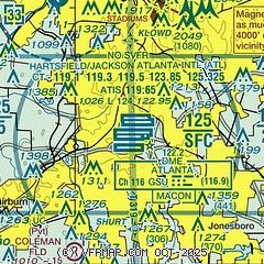
|
CAUTION: Diagram may not be current
 Download PDF
of official airport diagram from the FAA
| Airport distance calculator |
|---|
|
|
| Sunrise and sunset |
|---|
|
Times for 27-Jul-2026
| | Local
(UTC-4) | | Zulu
(UTC) |
|---|
| Morning civil twilight | | 06:20 | | 10:20 |
| Sunrise | | 06:47 | | 10:47 |
| Sunset | | 20:41 | | 00:41 |
| Evening civil twilight | | 21:09 | | 01:09 |
|
| Current date and time |
|---|
| Zulu (UTC) | 28-Jul-2026 03:28:52 |
|---|
| Local (UTC-4) | 27-Jul-2026 23:28:52 |
|---|
|
| METAR |
|---|
| KATL | 280252Z 25003KT 10SM BKN250 26/23 A2988 RMK AO2 SLP109 T02610228 51006 $
|
KFTY
10nm NW | 280253Z 00000KT 10SM BKN045 28/24 A2987 RMK AO2 SLP105 T02830239 51006
|
KHMP
16nm S | 280315Z AUTO 00000KT 10SM CLR 23/23 A2990 RMK AO2 T02320230
|
KPDK
16nm NE | 280253Z 15003KT 10SM CLR 26/23 A2988 RMK AO2 SLP101 T02560228 53007
|
KMGE
17nm N | 280255Z VRB01KT 9SM SCT250 28/24 A2986 RMK AO2A SLP099 T02760236 52006
|
KFFC
19nm S | 280253Z AUTO 00000KT 8SM CLR 26/25 A2989 RMK AO2 SLP115 T02560250 53008
|
|
| TAF |
|---|
| KATL | 280200Z 2802/2906 26005KT P6SM FEW040 BKN250 FM280300 30004KT P6SM FEW120 SCT200 FM281500 28008KT P6SM FEW040 SCT200 FM281900 28011KT P6SM SCT050 FM290100 27008KT P6SM SCT250
|
KFTY
10nm NW | 271733Z 2718/2818 31007KT P6SM FEW020 SCT035 FM280100 30003KT P6SM FEW250 FM281700 29007KT P6SM SCT040
|
KPDK
16nm NE | 271733Z 2718/2818 31007KT P6SM FEW020 SCT035 FM280100 30003KT P6SM FEW250 FM281700 29008KT P6SM SCT035
|
KMGE
17nm N | 272100Z 2721/2903 30010KT 9999 FEW035 SCT250 QNH2984INS BECMG 2801/2802 30005KT 9999 FEW250 QNH2983INS BECMG 2816/2817 27010G15KT 9999 VCTS BKN035CB BKN200 QNH2980INS BECMG 2901/2902 29007KT 9999 NSW FEW050 FEW200 QNH2975INS TX35/2821Z TN23/2812Z LAST NO AMDS AFT 2803 NEXT 2811
|
|
| NOTAMs |
|---|
NOTAMs are issued by the DoD/FAA and will open in a separate window not controlled by AirNav.
|
|


