FAA INFORMATION EFFECTIVE 19 MARCH 2026
Location
| FAA Identifier: | FFC |
| Lat/Long: | 33-21-27.8000N 084-34-21.1000W
33-21.463333N 084-34.351667W
33.3577222,-84.5725278
(estimated) |
| Elevation: | 807.7 ft. / 246.2 m (surveyed) |
| Variation: | 05W (2015) |
| From city: | 25 miles SW of ATLANTA, GA |
| Time zone: | UTC -4 (UTC -5 during Standard Time) |
| Zip code: | 30269 |
Airport Operations
| Airport use: | Open to the public |
| Activation date: | 10/1970 |
| Control tower: | no |
| ARTCC: | ATLANTA CENTER |
| FSS: | MACON FLIGHT SERVICE STATION |
| NOTAMs facility: | FFC (NOTAM-D service available) |
| Attendance: | 0700-2000, DECEMBER 25 CLSD, DECEMBER 24 0700-1200 |
| Wind indicator: | lighted |
| Segmented circle: | yes |
| Lights: | MIRL RWY 13/31 PRESET LOW INTST DUSK-2200; TO INCR INTST & ACTVT AFTER 2200 - CTAF. ACTVT ODALS RWY 31; PAPI RWYS 13 & 31; REIL RWY 13 - CTAF. |
| Beacon: | white-green (lighted land airport)
Operates sunset to sunrise. |
Airport Communications
| CTAF/UNICOM: | 123.05 |
| WX ASOS: | 118.525 (770-487-1610) |
| ATLANTA APPROACH: | 119.8 |
| ATLANTA DEPARTURE: | 119.8 |
| CLEARANCE DELIVERY: | 119.8 |
| WX AWOS-3PT at CCO (10 nm W): | 118.975 (770-254-1617) |
| WX AWOS-3 at HMP (12 nm E): | 124.825 (770-707-1719) |
| WX AWOS-3 at 6A2 (17 nm SE): | 119.750 (770-227-3934) |
| WX ASOS at ATL (18 nm NE): | PHONE 404-559-5166 |
Nearby radio navigation aids
| VOR radial/distance | | VOR name | | Freq | | Var |
|---|
| LGCr059/36.8 | | LAGRANGE VORTAC | | 115.60 | | 01E |
| NDB name | | Hdg/Dist | | Freq | | Var | | ID |
|---|
| PECAT | | 313/5.5 | | 316 | | 05W | | FFC | ..-. ..-. -.-. |
| COWETA COUNTY | | 052/9.3 | | 234 | | 03W | | EQQ | . --.- --.- |
| CARROLLTON | | 118/30.6 | | 278 | | 04W | | GPQ | --. .--. --.- |
Airport Services
| Fuel available: | 100LL JET-A+ |
| Parking: | hangars and tiedowns |
| Airframe service: | MAJOR |
| Powerplant service: | MAJOR |
| Bottled oxygen: | NONE |
| Bulk oxygen: | LOW |
Runway Information
Runway 13/31
| Dimensions: | 5768 x 100 ft. / 1758 x 30 m |
| Surface: | asphalt, in good condition |
| Weight bearing capacity: | | Single wheel: | 48.0 | | Double wheel: | 60.0 |
|
| Runway edge lights: | medium intensity |
| RUNWAY 13 | | RUNWAY 31 |
| Latitude: | 33-21.756485N | | 33-21.169177N |
| Longitude: | 084-34.797540W | | 084-33.906073W |
| Elevation: | 800.8 ft. | | 807.7 ft. |
| Traffic pattern: | right | | left |
| Runway heading: | 133 magnetic, 128 true | | 313 magnetic, 308 true |
| Displaced threshold: | 549 ft. | | 200 ft. |
| Declared distances: | TORA:5768 TODA:5768 ASDA:5174 LDA:4625 | | TORA:5768 TODA:5768 ASDA:5318 LDA:5118 |
| Markings: | nonprecision, in good condition | | precision, in good condition |
| Visual slope indicator: | 4-light PAPI on left (3.50 degrees glide path) | | 4-light PAPI on left (3.00 degrees glide path) |
| Approach lights: | | | ODALS: omnidirectional approach lighting system |
| Runway end identifier lights: | yes | | |
| Touchdown point: | yes, no lights | | yes, no lights |
| Instrument approach: | | | ILS/DME |
| Obstructions: | 91 ft. trees, 750 ft. from runway, 517 ft. right of centerline, 6:1 slope to clear
APCH SLP TO DSPLCD THLD 20:1. | | 23 ft. rr, 432 ft. from runway, 534 ft. right of centerline, 10:1 slope to clear
APCH SLP TO DSPLCD THLD 20:1. |
Helipad H1
| Dimensions: | 40 x 40 ft. / 12 x 12 m |
| Surface: | asphalt, in excellent condition |
| Latitude: | 33-21.483833N | | |
| Longitude: | 084-34.229667W | | |
| Elevation: | 797.1 ft. | | |
| Traffic pattern: | left | | left |
Airport Ownership and Management from official FAA records
| Ownership: | Publicly-owned |
| Owner: | PEACHTREE CITY ARPT AUTH
7 FALCON DRIVE
PEACHTREE CITY, GA 30269
Phone 770-487-2225 |
| Manager: | HOPE MACALUSO
7 FALCON DRIVE
PEACHTREE CITY, GA 30269
Phone 770-487-2225 |
Additional Remarks
| - | DEER ON AND INVOF OF ARPT. |
| - | ARPT MOWING IN PROG SPRING THRU AUTUMN. |
| - | PERIODIC CRANE OPS INVOF ARPT |
| - | FOR CD CTC ATLANTA APCH AT 678-364-6131. |
| - | BIRD ACT INCL GEESE INVOF ARPT |
| - | BE ALERT: FRQ FLT TRG IN AREA. |
| - | NO AP LDG FEES |
| - | THANKSGIVING FIXED BASED OPR OPN 0700-1200 |
Instrument Procedures
NOTE: All procedures below are presented as PDF files. If you need a reader for these files, you should download the free Adobe Reader.NOT FOR NAVIGATION. Please procure official charts for flight.
FAA instrument procedures published for use from 19 March 2026 at 0901Z to 16 April 2026 at 0900Z.
STARs - Standard Terminal Arrivals |
|---|
| BUKHD THREE (RNAV) | |
download (190KB) |
| DEHAN THREE (RNAV) | |
2 pages:
[1] [2] (326KB) |
IAPs - Instrument Approach Procedures |
|---|
| ILS OR LOC RWY 31 **CHANGED** | |
download (280KB) |
| RNAV (GPS) RWY 13 **CHANGED** | |
download (217KB) |
| RNAV (GPS) RWY 31 **CHANGED** | |
download (237KB) |
| NOTE: Special Alternate Minimums apply | |
download (154KB) |
| NOTE: Special Take-Off Minimums/Departure Procedures apply | |
download (479KB) |
Other nearby airports with instrument procedures:
KCCO - Newnan Coweta County Airport (10 nm W)
KHMP - Atlanta Speedway Airport (12 nm E)
6A2 - Griffin-Spalding County Airport (17 nm SE)
KATL - Hartsfield/Jackson Atlanta International Airport (18 nm NE)
KFTY - Fulton County Executive Airport/Charlie Brown Field (25 nm N)
|
|

Road maps at:
MapQuest
Bing
Google
| Aerial photo |
|---|
WARNING: Photo may not be current or correct
 Photo by Tim Vogt
Photo taken 22-Nov-2014
looking north.
Photo by Tim Vogt
Photo taken 22-Nov-2014
looking north.
Do you have a better or more recent aerial photo of Atlanta Regional Airport-Falcon Field that you would like to share? If so, please send us your photo.
|
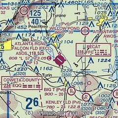
| Sectional chart |
|---|
|
CAUTION: Diagram may not be current

| Airport distance calculator |
|---|
|
|
| Sunrise and sunset |
|---|
|
Times for 13-Apr-2026
| | Local
(UTC-4) | | Zulu
(UTC) |
|---|
| Morning civil twilight | | 06:46 | | 10:46 |
| Sunrise | | 07:12 | | 11:12 |
| Sunset | | 20:06 | | 00:06 |
| Evening civil twilight | | 20:32 | | 00:32 |
|
| Current date and time |
|---|
| Zulu (UTC) | 14-Apr-2026 02:03:58 |
|---|
| Local (UTC-4) | 13-Apr-2026 22:03:58 |
|---|
|
| METAR |
|---|
| KFFC | 132353Z AUTO 00000KT 10SM CLR 23/12 A3022 RMK AO2 SLP232 T02330122 10278 20233 56006
|
KCCO
10nm W | 140155Z AUTO 00000KT 10SM CLR 19/11 A3024 RMK AO2 T01920106
|
KHMP
12nm E | 140155Z AUTO 00000KT 10SM CLR 16/12 A3027 RMK AO2 T01560124
|
K6A2
17nm SE | 140155Z AUTO 00000KT 5SM CLR 16/11 A3024 RMK AO2
|
KATL
18nm N | 140152Z 19005KT 10SM CLR 22/11 A3023 RMK AO2 SLP231 T02220111 $
|
|
| TAF |
|---|
KATL
18nm N | 132139Z 1322/1424 19008KT P6SM FEW070 SCT200 FM140100 20005KT P6SM SCT200 FM141400 25008KT P6SM FEW250
|
|
| NOTAMs |
|---|
NOTAMs are issued by the DoD/FAA and will open in a separate window not controlled by AirNav.
|
|


