FAA INFORMATION EFFECTIVE 19 FEBRUARY 2026
Location
| FAA Identifier: | AXQ |
| Lat/Long: | 41-13-29.8000N 079-26-31.8000W
41-13.496667N 079-26.530000W
41.2249444,-79.4421667
(estimated) |
| Elevation: | 1457.5 ft. / 444.2 m (surveyed) |
| Variation: | 10W (2005) |
| From city: | 3 miles NW of CLARION, PA |
| Time zone: | UTC -5 (UTC -4 during Daylight Saving Time) |
| Zip code: | 16254 |
Airport Operations
| Airport use: | Open to the public |
| Activation date: | 04/1974 |
| Control tower: | no |
| ARTCC: | CLEVELAND CENTER |
| FSS: | ALTOONA FLIGHT SERVICE STATION |
| NOTAMs facility: | AOO (NOTAM-D service available) |
| Attendance: | MON-FRI 0830-1600
UNATNDD MEML DAY, JULY 4TH, LABOR DAY, THANKSGIVING, CHRISTMAS, AND NEW YEARS DAY. |
| Wind indicator: | lighted |
| Segmented circle: | no |
| Lights: | ACTVT MIRL RY 06/24, REIL RYS 06 & 24 AND PAPI RYS 06 & 24 - CTAF. |
| Beacon: | white-green (lighted land airport)
Operates sunset to sunrise. |
| Landing fee: | yes |
Airport Communications
| CTAF/UNICOM: | 122.8 |
| WX AWOS-3: | 118.275 (814-297-1486) |
- APCH/DEP SVC PRVDD BY CLEVELAND ARTCC (ZOB) ON FREQS 126.725/291.65 (DUBOIS RCAG).
Nearby radio navigation aids
| VOR radial/distance | | VOR name | | Freq | | Var |
|---|
| FKLr130/(22.6) | | FRANKLIN VOR | | 109.60 | | 06W |
Airport Services
| Fuel available: | 100LL JET-A+
100LL:SNGL POINT RFLNG AVBL UPON REQ. JET A WITH PRIST AVBL SELF SVC 24 HRS. 100 LL AVBL SELF SVC 24 HRS. |
| Parking: | hangars and tiedowns |
| Bottled oxygen: | NONE |
| Bulk oxygen: | NONE |
Runway Information
Runway 6/24
| Dimensions: | 5003 x 75 ft. / 1525 x 23 m |
| Surface: | asphalt, in good condition |
| Weight bearing capacity: | |
| Runway edge lights: | medium intensity |
| RUNWAY 6 | | RUNWAY 24 |
| Latitude: | 41-13.203123N | | 41-13.788593N |
| Longitude: | 079-26.913500W | | 079-26.145995W |
| Elevation: | 1433.1 ft. | | 1457.4 ft. |
| Traffic pattern: | left | | left |
| Runway heading: | 055 magnetic, 045 true | | 235 magnetic, 225 true |
| Markings: | nonprecision, in good condition | | nonprecision, in good condition |
| Visual slope indicator: | 2-light PAPI on left (3.00 degrees glide path) | | 2-light PAPI on left (3.00 degrees glide path) |
| Runway end identifier lights: | yes | | yes |
| Touchdown point: | yes, no lights | | yes, no lights |
| Obstructions: | 12 ft. trees, 505 ft. from runway, 257 ft. left of centerline, 25:1 slope to clear | | 44 ft. trees, 851 ft. from runway, 329 ft. left of centerline, 14:1 slope to clear |
Airport Ownership and Management from official FAA records
| Ownership: | Publicly-owned |
| Owner: | CLARION COUNTY ARPT AUTH
395 AIRPORT RD
SHIPPENVILLE, PA 16254
Phone 814-226-9993 |
| Manager: | WILLIAM GUTH
395 AIRPORT ROAD
SHIPPENVILLE, PA 16254
Phone (814) 226-9993 |
Additional Remarks
| - | FOR CD CTC CLEVELAND ARTCC AT 440-774-0234/0442. |
Instrument Procedures
NOTE: All procedures below are presented as PDF files. If you need a reader for these files, you should download the free Adobe Reader.NOT FOR NAVIGATION. Please procure official charts for flight.
FAA instrument procedures published for use from 19 February 2026 at 0901Z to 19 March 2026 at 0900Z.
IAPs - Instrument Approach Procedures |
|---|
| RNAV (GPS) RWY 06 | |
download (232KB) |
| RNAV (GPS) RWY 24 | |
download (195KB) |
| NOTE: Special Take-Off Minimums/Departure Procedures apply | |
download (432KB) |
Other nearby airports with instrument procedures:
KFKL - Venango Regional Airport (21 nm NW)
KDUJ - Dubois Regional Airport (25 nm E)
6G1 - Titusville Airport (27 nm NW)
N35 - Punxsutawney Municipal Airport (28 nm SE)
6P7 - McVille Airport (30 nm S)
|
|

Road maps at:
MapQuest
Bing
Google
| Aerial photo |
|---|
WARNING: Photo may not be current or correct
 Photo by William Pixley
Photo taken 23-Aug-2016
looking east.
Photo by William Pixley
Photo taken 23-Aug-2016
looking east.
Do you have a better or more recent aerial photo of Clarion County Airport that you would like to share? If so, please send us your photo.
|
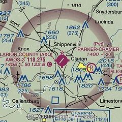
| Sectional chart |
|---|
|
CAUTION: Diagram may not be current

| Airport distance calculator |
|---|
|
|
| Sunrise and sunset |
|---|
|
Times for 04-Mar-2026
| | Local
(UTC-5) | | Zulu
(UTC) |
|---|
| Morning civil twilight | | 06:21 | | 11:21 |
| Sunrise | | 06:49 | | 11:49 |
| Sunset | | 18:11 | | 23:11 |
| Evening civil twilight | | 18:38 | | 23:38 |
|
| Current date and time |
|---|
| Zulu (UTC) | 05-Mar-2026 02:40:28 |
|---|
| Local (UTC-5) | 04-Mar-2026 21:40:28 |
|---|
|
| METAR |
|---|
KFKL
21nm NW | 050221Z AUTO 09005KT 3/4SM BR OVC002 08/08 A3013 RMK AO2
|
KDUJ
25nm E | 050212Z AUTO 00000KT 1/4SM FG VV002 06/06 A3016 RMK AO2 T00560056
|
KBTP
36nm SW | 050214Z AUTO 07005KT 1 1/2SM BR OVC005 09/ A3012 RMK AO2 CIG 002V008 $
|
KIDI
40nm SE | 050215Z AUTO 10005KT 1/4SM FG OVC003 09/09 A3015 RMK A01
|
|
| TAF |
|---|
KFKL
21nm NW | 042125Z 0421/0518 10006KT P6SM OVC015 FM042300 VRB03KT P6SM OVC008 FM050200 VRB02KT 3SM BR BKN004 FM050500 VRB02KT 1SM -RA BR OVC002 TEMPO 0505/0507 1/2SM FG FM050800 12004KT 1 1/2SM BR OVC002 TEMPO 0512/0514 1/2SM FG
|
KDUJ
25nm E | 050225Z 0502/0524 00000KT 1/4SM FG OVC002 FM050800 00000KT 2SM RA BR OVC002 FM051700 13005KT 1SM RA OVC003
|
|
| NOTAMs |
|---|
NOTAMs are issued by the DoD/FAA and will open in a separate window not controlled by AirNav.
|
|


