FAA INFORMATION EFFECTIVE 27 NOVEMBER 2025
Location
| FAA Identifier: | BHM |
| Lat/Long: | 33-33-50.0000N 086-45-08.3000W
33-33.833333N 086-45.138333W
33.5638889,-86.7523056
(estimated) |
| Elevation: | 650 ft. / 198.1 m (surveyed) |
| Variation: | 03W (2010) |
| From city: | 4 miles NE of BIRMINGHAM, AL |
| Time zone: | UTC -6 (UTC -5 during Daylight Saving Time) |
| Zip code: | 35212 |
Airport Operations
| Airport use: | Open to the public |
| Activation date: | 04/1940 |
| Control tower: | yes |
| ARTCC: | ATLANTA CENTER |
| FSS: | ANNISTON FLIGHT SERVICE STATION |
| NOTAMs facility: | BHM (NOTAM-D service available) |
| Attendance: | CONTINUOUS |
| Wind indicator: | lighted |
| Segmented circle: | no |
| Beacon: | white-green (lighted land airport)
Operates sunset to sunrise. |
| Fire and rescue: | ARFF index C |
| International operations: | customs landing rights airport |
Airport Communications
| UNICOM: | 122.95 |
| ATIS: | 119.4 270.1 |
| WX ASOS: | PHONE 205-591-6172 |
| BIRMINGHAM GROUND: | 121.7 348.6 |
| BIRMINGHAM TOWER: | 119.9 317.725 118.25 |
| BIRMINGHAM APPROACH: | 123.8 ;050-230 127.675 ;231-049 256.8 ;050-230 338.2 ;231-049 |
| BIRMINGHAM DEPARTURE: | 123.8 ;050-230 127.675 ;231-049 256.8 ;050-230 338.2 ;231-049 |
| CLEARANCE DELIVERY: | 125.675 305.2 |
| PRE-TAXI CLEARANCE: | 125.675 |
| CLASS C: | 123.8 ;050-230 127.675 ;231-049 256.8 ;050-230 338.2 ;231-049 |
| EMERG: | 121.5 243.0 |
| IC: | 123.8 ;050-230 256.8 ;050-230 |
| SFA: | 294.7 396.0 |
| WX AWOS-3PT at EKY (17 nm SW): | 118.825 (205-424-3127) |
Nearby radio navigation aids
| VOR radial/distance | | VOR name | | Freq | | Var |
|---|
| VUZr129/9.7 | | VULCAN VORTAC | | 114.40 | | 02E |
| OKWr052/31.7 | | BROOKWOOD VORTAC | | 111.00 | | 00E |
| NDB name | | Hdg/Dist | | Freq | | Var | | ID |
|---|
| MCDEN | | 059/5.6 | | 224 | | 03W | | BH | -... .... |
Airport Services
| Fuel available: | 100LL JET-A
A:A++100 (MIL) |
| Parking: | hangars and tiedowns |
| Airframe service: | MAJOR |
| Powerplant service: | MAJOR |
| Bottled oxygen: | NONE |
| Bulk oxygen: | HIGH/LOW |
Runway Information
Runway 6/24
| Dimensions: | 12007 x 150 ft. / 3660 x 46 m |
| Surface: | asphalt/grooved, in good condition |
| Weight bearing capacity: | | Single wheel: | 120.0 | | Double wheel: | 250.0 | | Double tandem: | 485.0 | | Dual double tandem: | 992.0 |
|
| Runway edge lights: | high intensity |
| RUNWAY 6 | | RUNWAY 24 |
| Latitude: | 33-33.286772N | | 33-34.408825N |
| Longitude: | 086-46.294145W | | 086-44.345812W |
| Elevation: | 603.4 ft. | | 650.0 ft. |
| Traffic pattern: | left | | left |
| Runway heading: | 058 magnetic, 055 true | | 238 magnetic, 235 true |
| Displaced threshold: | no | | 1205 ft. |
| Declared distances: | TORA:12007 TODA:12007 ASDA:12007 LDA:12007 | | TORA:12007 TODA:12007 ASDA:12007 LDA:10801 |
| Markings: | precision, in fair condition | | precision, in fair condition |
| Visual slope indicator: | 4-light PAPI on left (3.00 degrees glide path) | | 4-light PAPI on left (3.00 degrees glide path) |
| RVR equipment: | touchdown, midfield, rollout | | touchdown, midfield, rollout |
| Approach lights: | ALSF2: standard 2,400 foot high intensity approach lighting system with centerline sequenced flashers (category II or III) | | MALSR: 1,400 foot medium intensity approach lighting system with runway alignment indicator lights
MALSR ATCT CTLD, OPS UMMONITORED. |
| Centerline lights: | yes | | yes |
| Touchdown point: | yes, lighted | | yes, no lights |
| Instrument approach: | ILS | | ILS/DME |
| Obstructions: | 58 ft. trees, 1290 ft. from runway, 654 ft. right of centerline, 18:1 slope to clear | | 67 ft. gnd, 1323 ft. from runway, 610 ft. right of centerline, 16:1 slope to clear
NAVAID SHELTER 149 FT FM RWY END, 405 FT L, 1 FT ABV RWY END ELEV. |
Runway 18/36
| Dimensions: | 7099 x 150 ft. / 2164 x 46 m |
| Surface: | asphalt/grooved, in good condition |
| Weight bearing capacity: | | Single wheel: | 105.0 | | Double wheel: | 143.0 | | Double tandem: | 197.0 |
|
| Runway edge lights: | medium intensity |
| RUNWAY 18 | | RUNWAY 36 |
| Latitude: | 33-34.392808N | | 33-33.222310N |
| Longitude: | 086-44.831415W | | 086-44.832012W |
| Elevation: | 644.3 ft. | | 633.5 ft. |
| Traffic pattern: | left | | left |
| Runway heading: | 183 magnetic, 180 true | | 003 magnetic, 000 true |
| Declared distances: | TORA:7099 TODA:7099 ASDA:7099 LDA:7099 | | TORA:7099 TODA:7099 ASDA:7099 LDA:7099 |
| Markings: | nonprecision, in good condition | | nonprecision, in good condition |
| Visual slope indicator: | 4-light PAPI on left (3.20 degrees glide path) | | |
| Runway end identifier lights: | yes | | yes |
| Touchdown point: | yes, no lights | | yes, no lights |
| Instrument approach: | LOC/DME | | |
| Obstructions: | 245 ft. trees, 5689 ft. from runway, 883 ft. right of centerline, 22:1 slope to clear | | 62 ft. trees, 1340 ft. from runway, 210 ft. left of centerline, 18:1 slope to clear |
Airport Ownership and Management from official FAA records
| Ownership: | Publicly-owned |
| Owner: | BIRMINGHAM AIRPORT AUTHORITY
5900 MESSER AIRPORT HWY
BIRMINGHAM, AL 35212
Phone (205) 599-0505 |
| Manager: | RONALD MATHIEU
BIRMINGHAM AIRPORT AUTHORITY, 5900 MESSER AIRPORT HWY
BIRMINGHAM, AL 35212
Phone (205) 599-0505 |
Additional Remarks
| A39-18/36 | PCR VALUE: 440/F/D/X/T |
| A39-06/24 | PCR VALUE: 1102/F/D/X/T |
| - | TWY F BTN RWY 18/36 & TWY G RSTRD TO ACFT 100000 LBS OR LESS. |
| - | ANG: PPR RQR FOR ANG RAMP. NML OPR HRS 1300-2330Z++ TUE-FRI, CLSD WKNDS & HOL. NO SVC AVBL OUTSIDE THESE HRS WITHOUT PRIOR APVL. NO LCL OR ROUND-ROBIN FLT BY TRAN ACFT. CALL AIRFIELD OPS DSN 778-2555, C205-714-2555 FOR PPR 72 HR PRIOR (96 HRS FOR CARGO MSN). ALL INBD ACFT CTC ANG COMD POST "VULCN CONTROL" NO LATER THAN 15 MIN PRIOR TO LDG WITH PPR NR AND SUPPORT REQ. SPACE-A CAPABILITIES EXTREMELY LTD, PAX SVC LTD AVAILABILITY. |
| - | TWY H S OF TWY H4 RSTRD TO ACFT WITH WINGSPAN LESS THAN 118 FT. |
| - | TWY A BTN TWY A HLDG BAY AND TWY A3 RSTRD TO ACFT WITH WINGSPAN LESS THAN 150 FT. |
| - | TWY H2 RSTRD TO ACFT WITH WINGSPAN LESS THAN 105 FT. |
| - | TWY G RSTRD TO ACFT 65000 LBS OR LESS. |
| - | TWY H3 RSTRD TO ACFT WITH WINGSPAN LESS THAN 105 FT. |
| - | TWY M N OF RWY 6/24 RSTRD TO ACFT 75000 LBS OR LESS. |
| - | TWY N RSTRD TO ACFT 204000 LBS OR LESS. |
| - | BIRD ACTV INVOF RWYS. |
Instrument Procedures
NOTE: All procedures below are presented as PDF files. If you need a reader for these files, you should download the free Adobe Reader.NOT FOR NAVIGATION. Please procure official charts for flight.
FAA instrument procedures published for use from 27 November 2025 at 0901Z to 25 December 2025 at 0900Z.
IAPs - Instrument Approach Procedures |
|---|
| ILS OR LOC RWY 06 | |
download (282KB) |
| ILS OR LOC RWY 24 | |
download (303KB) |
| ILS RWY 06 (CAT II) | |
download (257KB) |
| ILS RWY 24 (SA CAT II) | |
download (284KB) |
| RNAV (RNP) Z RWY 06 | |
download (306KB) |
| RNAV (RNP) Z RWY 24 | |
download (316KB) |
| RNAV (GPS) RWY 18 | |
download (206KB) |
| RNAV (GPS) RWY 36 | |
download (219KB) |
| RNAV (GPS) Y RWY 06 | |
download (232KB) |
| RNAV (GPS) Y RWY 24 | |
download (257KB) |
| LOC RWY 18 | |
download (255KB) |
| NOTE: Special Alternate Minimums apply | |
download (139KB) |
Departure Procedures |
|---|
| BIRMINGHAM EIGHT | |
2 pages:
[1] [2] (285KB) |
| NOTE: Special Take-Off Minimums/Departure Procedures apply | |
download (328KB) |
Other nearby airports with instrument procedures:
KEKY - Bessemer National Airport (17 nm SW)
KEET - Shelby County Airport (23 nm S)
KPLR - St Clair County Airport (25 nm E)
20A - Robbins Field Airport (31 nm NE)
KSCD - Merkel Field Sylacauga Municipal Airport (32 nm SE)
|
|

Road maps at:
MapQuest
Bing
Google
| Aerial photo |
|---|
WARNING: Photo may not be current or correct
 Photo courtesy of Sellersphoto.com
Photo taken 02-Aug-2012
looking southwest.
Photo courtesy of Sellersphoto.com
Photo taken 02-Aug-2012
looking southwest.
Do you have a better or more recent aerial photo of Birmingham-Shuttlesworth International Airport that you would like to share? If so, please send us your photo.
|
| Sectional chart |
|---|
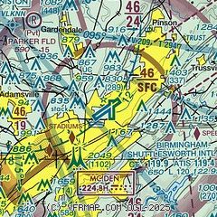
|
 Download PDF
of official airport diagram from the FAA
| Airport distance calculator |
|---|
|
|
| Sunrise and sunset |
|---|
|
Times for 29-Nov-2025
| | Local
(UTC-6) | | Zulu
(UTC) |
|---|
| Morning civil twilight | | 06:05 | | 12:05 |
| Sunrise | | 06:33 | | 12:33 |
| Sunset | | 16:38 | | 22:38 |
| Evening civil twilight | | 17:05 | | 23:05 |
|
| Current date and time |
|---|
| Zulu (UTC) | 29-Nov-2025 20:56:05 |
|---|
| Local (UTC-6) | 29-Nov-2025 14:56:05 |
|---|
|
| METAR |
|---|
| KBHM | 291953Z 12008KT 10SM FEW090 BKN120 OVC250 11/M07 A3029 RMK AO2 SLP259 T01061072
|
KEKY
17nm SW | 291956Z AUTO VRB04KT OVC110 11/M07 A3027 RMK AO2 SLP231 T01061072 PWINO RVRNO $
|
|
| TAF |
|---|
| KBHM | 291726Z 2918/3018 15009KT P6SM BKN120 FM300000 14005KT P6SM OVC080 FM301000 VRB03KT P6SM -SHRA OVC050 FM301400 33005KT 4SM -SHRA BR OVC015
|
|
| NOTAMs |
|---|
NOTAMs are issued by the DoD/FAA and will open in a separate window not controlled by AirNav.
|
|


