FAA INFORMATION EFFECTIVE 27 NOVEMBER 2025
Location
| FAA Identifier: | BNA |
| Lat/Long: | 36-07-28.1100N 086-40-41.4500W
36-07.468500N 086-40.690833W
36.1244750,-86.6781806
(estimated) |
| Elevation: | 599 ft. / 182.6 m (surveyed) |
| Variation: | 03W (2010) |
| From city: | 5 miles SE of NASHVILLE, TN |
| Time zone: | UTC -6 (UTC -5 during Daylight Saving Time) |
| Zip code: | 37217 |
Airport Operations
| Airport use: | Open to the public |
| Activation date: | 12/1937 |
| Control tower: | yes |
| ARTCC: | MEMPHIS CENTER |
| FSS: | NASHVILLE FLIGHT SERVICE STATION |
| NOTAMs facility: | BNA (NOTAM-D service available) |
| Attendance: | CONTINUOUS |
| Wind indicator: | lighted |
| Segmented circle: | no |
| Lights: | SS-SR |
| Beacon: | white-green (lighted land airport)
Operates sunset to sunrise. |
| Fire and rescue: | ARFF index D |
| International operations: | customs landing rights airport |
Airport Communications
| UNICOM: | 122.95 |
| WX ASOS: | PHONE 629-236-5115 |
| NASHVILLE GROUND: | 121.9 348.6 |
| NASHVILLE TOWER: | 118.6 257.8 |
| NASHVILLE APPROACH: | 118.4 ;030-196 119.35 ;197-029 360.7 ;030-196 372.0 ;197-029 |
| NASHVILLE DEPARTURE: | 118.4 ;030-196 119.35 ;197-029 360.7 ;030-196 372.0 ;197-029 |
| CLEARANCE DELIVERY: | 126.05 |
| PRE-TAXI CLEARANCE: | 126.05 |
| ALCP: | 314.4 |
| CHADM DP: | 118.4 360.7 |
| CHSNE STAR: | 119.35 372.0 |
| CLASS C: | 118.4 ;030-196 119.35 ;197-029 360.7 ;030-196 372.0 ;197-029 |
| D-ATIS: | 135.1 |
| DANLS DP: | 119.35 372.0 |
| DRURY DP: | 119.35 372.0 |
| EMERG: | 121.5 243.0 |
| EVVAN DP: | 118.4 360.7 |
| FLAME DP: | 118.4 360.7 |
| GDOGG DP: | 119.35 372.0 |
| HGGRD DP: | 119.35 372.0 |
| IC: | 118.4 ;030-196 119.35 ;197-029 360.7 ;030-196 372.0 ;197-029 |
| KRSTA DP: | 119.35 372.0 |
| NASHVILLE DP: | 118.4 ;EAST 119.35 ;WEST 360.7 ;EAST 372.0 ;WEST |
| PARDN DP: | 119.35 372.0 |
| PASLY STAR: | 118.4 360.7 |
| RYYMN STAR: | 119.35 372.0 |
| SWFFT STAR: | 118.4 360.7 |
| TAZMO DP: | 118.4 360.7 |
| TIPPN DP: | 118.4 360.7 |
| WX AWOS-3PT at MQY (10 nm SE): | 119.125 (615-223-7716) |
| WX AWOS-3 at JWN (11 nm W): | PHONE 615-350-6222 |
| WX AWOS-3 at M54 (18 nm E): | 118.325 (615-444-5778) |
| WX AWOS-3 at XNX (20 nm NE): | 132.725 (615-230-8005) |
- SAID IN USE. OPERATE TRANSPONDERS WITH ALTITUDE REPORTING MODE AND ADS-B (IF EQUIPPED) ENABLED ON ALL AIRPORT SURFACES.
Nearby radio navigation aids
| VOR radial/distance | | VOR name | | Freq | | Var |
|---|
| BNA at field | | NASHVILLE VORTAC | | 114.10 | | 02W |
| SYIr342/35.7 | | SHELBYVILLE VOR/DME | | 113.55 | | 01W |
Airport Services
| Fuel available: | 100LL JET-A |
| Parking: | hangars and tiedowns |
| Airframe service: | MAJOR |
| Powerplant service: | MAJOR |
| Bottled oxygen: | LOW |
| Bulk oxygen: | LOW |
Runway Information
Runway 13/31
| Dimensions: | 11030 x 150 ft. / 3362 x 46 m |
| Surface: | concrete/grooved, in good condition |
| Runway edge lights: | high intensity |
| RUNWAY 13 | | RUNWAY 31 |
| Latitude: | 36-08.476652N | | 36-07.229753N |
| Longitude: | 086-41.721313W | | 086-40.090640W |
| Elevation: | 535.9 ft. | | 582.3 ft. |
| Traffic pattern: | left | | left |
| Runway heading: | 136 magnetic, 133 true | | 316 magnetic, 313 true |
| Displaced threshold: | 800 ft. | | 741 ft. |
| Declared distances: | TORA:10288 TODA:11029 ASDA:10288 LDA:9487 | | TORA:10228 TODA:11029 ASDA:10228 LDA:9487 |
| Markings: | precision, in good condition | | precision, in good condition |
| Visual slope indicator: | | | 4-light PAPI on right (3.00 degrees glide path) |
| Runway end identifier lights: | yes | | yes |
| Touchdown point: | yes, no lights | | yes, no lights |
| Instrument approach: | | | ILS |
| Obstructions: | trees, 34:1 slope to clear
APCH RATIO 50:1 TO DTHR. | | tree
APCH RATIO 50:1 TO DTHR. |
Runway 2C/20C
| Dimensions: | 8001 x 150 ft. / 2439 x 46 m |
| Surface: | concrete/grooved, in good condition |
| Weight bearing capacity: | | Single wheel: | 120.0 | | Double wheel: | 204.0 | | Double tandem: | 386.0 | | Dual double tandem: | 885.0 |
|
| Runway edge lights: | high intensity |
| RUNWAY 2C | | RUNWAY 20C |
| Latitude: | 36-06.199832N | | 36-07.454010N |
| Longitude: | 086-41.277652W | | 086-40.775833W |
| Elevation: | 569.1 ft. | | 571.8 ft. |
| Traffic pattern: | left | | left |
| Runway heading: | 021 magnetic, 018 true | | 201 magnetic, 198 true |
| Declared distances: | TORA:8001 TODA:8001 ASDA:7601 LDA:7601 | | TORA:8001 TODA:8001 ASDA:8001 LDA:8001 |
| Markings: | precision, in good condition | | precision, in good condition |
| Visual slope indicator: | 4-light PAPI on left (3.00 degrees glide path) | | 4-light PAPI on left (3.00 degrees glide path) |
| RVR equipment: | touchdown | | rollout |
| Approach lights: | MALSR: 1,400 foot medium intensity approach lighting system with runway alignment indicator lights | | |
| Runway end identifier lights: | | | yes |
| Touchdown point: | yes, no lights | | yes, no lights |
| Instrument approach: | LOC/GS | | |
Runway 2R/20L
| Dimensions: | 8001 x 150 ft. / 2439 x 46 m |
| Surface: | concrete/grooved, in good condition |
| Runway edge lights: | high intensity |
| RUNWAY 2R | | RUNWAY 20L |
| Latitude: | 36-06.762783N | | 36-08.016860N |
| Longitude: | 086-40.058563W | | 086-39.556592W |
| Elevation: | 589.8 ft. | | 540.0 ft. |
| Traffic pattern: | left | | left |
| Runway heading: | 021 magnetic, 018 true | | 201 magnetic, 198 true |
| Declared distances: | TORA:8000 TODA:8000 ASDA:8000 LDA:8000 | | TORA:8000 TODA:8000 ASDA:8000 LDA:8000 |
| Markings: | precision, in good condition | | precision, in good condition |
| Visual slope indicator: | | | 4-light PAPI on left (3.00 degrees glide path) |
| RVR equipment: | touchdown, midfield, rollout | | touchdown, midfield, rollout |
| Approach lights: | ALSF2: standard 2,400 foot high intensity approach lighting system with centerline sequenced flashers (category II or III) | | MALSR: 1,400 foot medium intensity approach lighting system with runway alignment indicator lights |
| Centerline lights: | yes | | yes |
| Touchdown point: | yes, lighted | | yes, no lights |
| Instrument approach: | ILS/DME | | ILS/DME |
Runway 2L/20R
| Dimensions: | 7704 x 150 ft. / 2348 x 46 m |
| Surface: | concrete/grooved, in good condition |
| Runway edge lights: | high intensity |
| RUNWAY 2L | | RUNWAY 20R |
| Latitude: | 36-07.060570N | | 36-08.270540N |
| Longitude: | 086-41.188508W | | 086-40.713892W |
| Elevation: | 598.7 ft. | | 555.6 ft. |
| Traffic pattern: | left | | left |
| Runway heading: | 021 magnetic, 018 true | | 201 magnetic, 198 true |
| Declared distances: | TORA:7702 TODA:7702 ASDA:7702 LDA:7702 | | TORA:7702 TODA:7702 ASDA:7702 LDA:7702 |
| Markings: | precision, in good condition | | precision, in good condition |
| Visual slope indicator: | 4-light PAPI on right (3.00 degrees glide path) | | 4-light PAPI on right (3.00 degrees glide path) |
| RVR equipment: | touchdown, rollout | | touchdown, rollout |
| Approach lights: | ALSF2: standard 2,400 foot high intensity approach lighting system with centerline sequenced flashers (category II or III) | | MALSF: 1,400 foot medium intensity approach lighting system with sequenced flashers |
| Centerline lights: | yes | | yes |
| Touchdown point: | yes, lighted | | yes, no lights |
| Instrument approach: | ILS/DME | | ILS |
Airport Ownership and Management from official FAA records
| Ownership: | Publicly-owned |
| Owner: | METRO NASHVILLE ARPT AUTH
140 BNA PARK DR. SUITE 520
NASHVILLE, TN 37214
Phone 615-275-1600 |
| Manager: | ADAM FLOYD
140 BNA PARK DR. SUITE 520
NASHVILLE, TN 37214
Phone 615-275-1546 |
Additional Remarks
| A39-02C/20C | PCR VALUE: 615/R/A/W/T |
| A39-13/31 | PCR VALUE: 762/R/A/W/T |
| A39-02R/20L | PCR VALUE: 727/R/A/W/T |
| A39-02L/20R | PCR VALUE: 897/R/A/W/T |
| A30A-13 | LGTD JET BLAST FENCE 568 FT MSL 1167 FT NW THR. |
| A30A-31 | LGTD JET BLAST FENCE 598 FT MSL 1100 FT SE THR. |
| - | 180 DEG TURNS OVR 12500 LBS NA ON ASPH SFC. |
| - | FLT OVR MAIN TRML NA. |
| - | BIRD ACT ON & INVOF ARPT. |
| - | DO NOT CONFUSE TWY S FOR RWY 20C. |
| - | CTN: READ BACK & COMPLIANCE OF RWY HLDG INSTRN RQR; SPCLY TWY K & RWY 20C, TWY L AT RWY 13 & TWY H AT RWY 31. |
| - | ANG: PPR - PPR RQR 48 HOURS PRIOR FOR ALL TRAN ACFT. CASHH OPS 615-367-5567. |
| - | MIL & ACFT MORE THAN 12500 LB PRAC APCH NA; PRAC APCH BTN 2300-0700 NA. |
| - | TRML APRON TAX BTN ACR PUSHBACK OPS & GATES NA. |
| - | ADHERE TO TWY & TXL CNTRLN WI TRML APRON. |
| - | BNA SVC NORTH RAMP TWR OPN DLY- 0400- 0100 - 131.90. |
| - | FLT NOTIFICATION SVC (ADCUS) AVBL. |
| - | PAVEMENT ON W SIDE OF RWY 2R/20L BTN TXY H3 & H4 MKD AS A VEHICLE ACES ROAD ONLY. |
| - | BNA SVC SOUTH RAMP TWR OPN DLY- 0400-0100 - 129.95. |
| - | TRML APRON TXL Z, Y1, Y2 & TXL Y BTN TXL Y3 & Y4 CLSD TO WINGSPAN MORE THAN 118 FT. |
| - | BNA SVC CNTRL RAMP/GUITAR PICK RAMP TWR OPN DLY 0400-0100 - 131.375. |
| - | 96 HR PPR FOR WINGSPAN GTR THAN 214 FT - 615-275-1612. |
| - | PPR BFR GA & CARGO PROCD TO AIRLINE TRML GATE FOR DEICE OPS. |
| - | PILOTS CONDUCTING EFVS OPS; BE AWARE LED ALS IN USE RWY 20R. |
| - | LGTD PERIMETER FENCE LCTD IN ROFA, WEST OF RWY 2C/20C AT MIDPT. |
| - | TBJT RWY NOISE ABATEMENT PROC; MIL TBJT USE RWY 13/31 FOR ARR & DEP. |
Instrument Procedures
NOTE: All procedures below are presented as PDF files. If you need a reader for these files, you should download the free Adobe Reader.NOT FOR NAVIGATION. Please procure official charts for flight.
FAA instrument procedures published for use from 27 November 2025 at 0901Z to 25 December 2025 at 0900Z.
STARs - Standard Terminal Arrivals |
|---|
| CHSNE THREE (RNAV) | |
2 pages:
[1] [2] (330KB) |
| CHSNE THREE (RNAV), CONT.2 | |
download (197KB) |
| PASLY FIVE (RNAV) | |
2 pages:
[1] [2] (387KB) |
| RYYMN THREE (RNAV) | |
2 pages:
[1] [2] (456KB) |
| SWFFT THREE (RNAV) | |
2 pages:
[1] [2] (406KB) |
IAPs - Instrument Approach Procedures |
|---|
| ILS OR LOC RWY 02C **CHANGED** | |
download (301KB) |
| ILS OR LOC RWY 02L **CHANGED** | |
download (290KB) |
| ILS OR LOC RWY 02R **CHANGED** | |
download (289KB) |
| ILS OR LOC RWY 20L **CHANGED** | |
download (303KB) |
| ILS OR LOC RWY 20R **CHANGED** | |
download (341KB) |
| ILS OR LOC RWY 31 **CHANGED** | |
download (304KB) |
| ILS RWY 02L (SA CAT I) **CHANGED** | |
download (262KB) |
| ILS RWY 02R (SA CAT I) **CHANGED** | |
download (268KB) |
| ILS RWY 02L (CAT II - III) **CHANGED** | |
download (272KB) |
| ILS RWY 02R (CAT II - III) **CHANGED** | |
download (278KB) |
| RNAV (RNP) Z RWY 02C **CHANGED** | |
download (281KB) |
| RNAV (RNP) Z RWY 02L **CHANGED** | |
download (278KB) |
| RNAV (RNP) Z RWY 02R **CHANGED** | |
download (286KB) |
| RNAV (RNP) Z RWY 20L **CHANGED** | |
download (296KB) |
| RNAV (RNP) Z RWY 20R **CHANGED** | |
download (300KB) |
| RNAV (RNP) Z RWY 31 **CHANGED** | |
download (223KB) |
| RNAV (GPS) RWY 13 **CHANGED** | |
download (269KB) |
| RNAV (GPS) RWY 20C **CHANGED** | |
download (251KB) |
| RNAV (GPS) Y RWY 02C **CHANGED** | |
download (272KB) |
| RNAV (GPS) Y RWY 02L **CHANGED** | |
download (259KB) |
| RNAV (GPS) Y RWY 02R **CHANGED** | |
download (288KB) |
| RNAV (GPS) Y RWY 20L **CHANGED** | |
download (300KB) |
| RNAV (GPS) Y RWY 20R **CHANGED** | |
download (310KB) |
| RNAV (GPS) Y RWY 31 **CHANGED** | |
download (235KB) |
| NOTE: Special Alternate Minimums apply | |
download (142KB) |
Departure Procedures |
|---|
| CHADM FOUR (RNAV) **NEW** | |
2 pages:
[1] [2] (433KB) |
| DANLS FOUR (RNAV) **NEW** | |
2 pages:
[1] [2] (428KB) |
| DRURY FOUR (RNAV) **NEW** | |
2 pages:
[1] [2] (382KB) |
| FLAME FOUR (RNAV) **NEW** | |
2 pages:
[1] [2] (364KB) |
| GDOGG FOUR (RNAV) **NEW** | |
2 pages:
[1] [2] (383KB) |
| KRSTA FOUR (RNAV) **NEW** | |
2 pages:
[1] [2] (373KB) |
| NASHVILLE SEVEN | |
2 pages:
[1] [2] (308KB) |
| PARDN FOUR (RNAV) **NEW** | |
2 pages:
[1] [2] (435KB) |
| TAZMO FOUR (RNAV) **NEW** | |
2 pages:
[1] [2] (441KB) |
| TIPPN FOUR (RNAV) **NEW** | |
2 pages:
[1] [2] (376KB) |
| NOTE: Special Take-Off Minimums/Departure Procedures apply | |
download (193KB) |
Other nearby airports with instrument procedures:
KMQY - Smyrna Airport (10 nm SE)
KJWN - John C Tune Airport (11 nm W)
M54 - Lebanon Municipal Airport (18 nm E)
KXNX - Music City Executive Airport (20 nm NE)
KMBT - Murfreesboro Municipal Airport (21 nm SE)
|
|

Road maps at:
MapQuest
Bing
Google
| Aerial photo |
|---|
WARNING: Photo may not be current or correct

Do you have a better or more recent aerial photo of Nashville International Airport that you would like to share? If so, please send us your photo.
|
| Sectional chart |
|---|
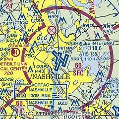
|
CAUTION: Diagram may not be current
 Download PDF
of official airport diagram from the FAA
| Airport distance calculator |
|---|
|
|
| Sunrise and sunset |
|---|
|
Times for 15-Dec-2025
| | Local
(UTC-6) | | Zulu
(UTC) |
|---|
| Morning civil twilight | | 06:23 | | 12:23 |
| Sunrise | | 06:51 | | 12:51 |
| Sunset | | 16:32 | | 22:32 |
| Evening civil twilight | | 17:01 | | 23:01 |
|
| Current date and time |
|---|
| Zulu (UTC) | 15-Dec-2025 20:31:31 |
|---|
| Local (UTC-6) | 15-Dec-2025 14:31:31 |
|---|
|
| METAR |
|---|
| KBNA | 151953Z 20008KT 10SM CLR 03/M14 A3035 RMK AO2 SLP283 T00331144 $
|
KMQY
10nm SE | 151956Z 17008KT 10SM CLR 04/M13 A3036 RMK AO2 SLPNO T00391128
|
KJWN
11nm W | 151950Z 21007KT 10SM CLR 03/M15 A3032
|
KM54
18nm E | 152010Z AUTO 20006KT 10SM CLR 03/M12 A3031 RMK A01
|
KXNX
20nm NE | 152015Z AUTO VRB04KT 10SM CLR 03/M14 A3036 RMK A01
|
|
| TAF |
|---|
| KBNA | 151722Z 1518/1618 21007KT P6SM SKC
|
KMQY
10nm SE | 151722Z 1518/1618 20006KT P6SM SKC
|
|
| NOTAMs |
|---|
NOTAMs are issued by the DoD/FAA and will open in a separate window not controlled by AirNav.
|
|


