FAA INFORMATION EFFECTIVE 10 JULY 2025
Location
| FAA Identifier: | CAD |
| Lat/Long: | 44-16-31.2510N 085-25-08.2000W
44-16.520850N 085-25.136667W
44.2753475,-85.4189444
(estimated) |
| Elevation: | 1306.5 ft. / 398.2 m (surveyed) |
| Variation: | 04W (1985) |
| From city: | 2 miles NNW of CADILLAC, MI |
| Time zone: | UTC -4 (UTC -5 during Standard Time) |
| Zip code: | 49601 |
Airport Operations
| Airport use: | Open to the public |
| Activation date: | 04/1942 |
| Control tower: | no |
| ARTCC: | MINNEAPOLIS CENTER |
| FSS: | LANSING FLIGHT SERVICE STATION |
| NOTAMs facility: | CAD (NOTAM-D service available) |
| Attendance: | MON-FRI 0700-1700, MAY-SEP SAT 0800-1200
FOR AFT HRS ATNDNC CALL 231-779-9211 SUBJ CALL-IN FEE. UNATNDD MAJOR HOLS. |
| Wind indicator: | lighted |
| Segmented circle: | yes |
| Lights: | ACTVT MALSF RWY 07; REIL RWY 07 & 25; VASI RWY 07; PAPI RWY 25; HIRL RWY 07/25 - CTAF. |
| Beacon: | white-green (lighted land airport)
Operates sunset to sunrise. |
| Landing fee: | no, LDG FEE FOR COML OPS WAIVED WITH MNM FUEL PURCHASE. |
Airport Communications
| CTAF/UNICOM: | 122.8 |
| WX AWOS-3P: | 128.325 (231-779-9536) |
- APCH/DEP SVC PRVDD BY MINNEAPOLIS ARTCC ON 132.9/338.3 (TRAVERSE CITY RCAG).
Nearby radio navigation aids
| VOR radial/distance | | VOR name | | Freq | | Var |
|---|
| TVCr169/24.2 | | TRAVERSE CITY VOR/DME | | 114.60 | | 02W |
| CGGr236/(38.3) | | GRAYLING VOR | | 109.80 | | 06W |
| NDB name | | Hdg/Dist | | Freq | | Var | | ID |
|---|
| WEXOR | | 071/6.0 | | 336 | | 04W | | MA | -- .- |
| GRAYLING | | 228/38.1 | | 359 | | 06W | | GYG | --. -.-- --. |
Airport Services
| Fuel available: | 100LL JET-A
100LL:AVBL H24 SELF SVC. |
| Parking: | hangars and tiedowns |
| Airframe service: | MAJOR |
| Powerplant service: | MAJOR |
Runway Information
Runway 7/25
| Dimensions: | 5001 x 100 ft. / 1524 x 30 m |
| Surface: | asphalt/porous friction courses, in good condition |
| Weight bearing capacity: | | Single wheel: | 30.0 | | Double wheel: | 45.0 |
|
| Runway edge lights: | high intensity |
| RUNWAY 7 | | RUNWAY 25 |
| Latitude: | 44-16.372863N | | 44-16.702885N |
| Longitude: | 085-25.850740W | | 085-24.801382W |
| Elevation: | 1306.5 ft. | | 1297.9 ft. |
| Traffic pattern: | left | | left |
| Runway heading: | 070 magnetic, 066 true | | 250 magnetic, 246 true |
| Markings: | precision, in good condition | | precision, in good condition |
| Visual slope indicator: | 4-box VASI on left (3.00 degrees glide path) | | 4-light PAPI on left (3.00 degrees glide path) |
| Approach lights: | MALSF: 1,400 foot medium intensity approach lighting system with sequenced flashers | | |
| Runway end identifier lights: | yes | | yes |
| Touchdown point: | yes, no lights | | yes, no lights |
| Instrument approach: | ILS/DME | | |
| Obstructions: | 42 ft. tree, 901 ft. from runway, 372 ft. right of centerline, 16:1 slope to clear | | 37 ft. pole, 1372 ft. from runway, 626 ft. right of centerline, 31:1 slope to clear |
Runway 18/36
| Dimensions: | 1986 x 150 ft. / 605 x 46 m |
| Surface: | turf, in fair condition |
| Runway edge markings: | 3 FT YELLOW CONES. |
| Operational restrictions: | CLSD DEC-MAR & WHEN SNOW COVD EXC FOR SKI EQUIPPED ACFT. |
| RUNWAY 18 | | RUNWAY 36 |
| Latitude: | 44-16.641300N | | 44-16.314533N |
| Longitude: | 085-24.661892W | | 085-24.657345W |
| Elevation: | 1293.7 ft. | | 1296.5 ft. |
| Traffic pattern: | left | | left |
| Runway heading: | 183 magnetic, 179 true | | 003 magnetic, 359 true |
| Runway end identifier lights: | no | | no |
| Touchdown point: | yes, no lights | | yes, no lights |
| Obstructions: | none | | 51 ft. tree, 1153 ft. from runway, 237 ft. left of centerline, 18:1 slope to clear |
Airport Ownership and Management from official FAA records
| Ownership: | Publicly-owned |
| Owner: | WEXFORD CO ARPT AUTH
8040 E 34 RD
CADILLAC, MI 49601-9015
Phone 231-779-9525 |
| Manager: | KEITH NEWELL
8040 E 34 RD
CADILLAC, MI 49601-9015
Phone 231-878-5178
CELL. |
Additional Remarks
| - | DEER & LRG BIRDS ON & INVOF ARPT. |
| - | ADMIN BLDG EAST DOOR ACES 5-3-2-1. |
| - | GLDR & ULTRALIGHT ACT ON & INVOF ARPT APR-OCT. |
| - | FOR CD CTC MINNEAPOLIS ARTCC AT 651-463-5588. |
Instrument Procedures
NOTE: All procedures below are presented as PDF files. If you need a reader for these files, you should download the free Adobe Reader.NOT FOR NAVIGATION. Please procure official charts for flight.
FAA instrument procedures published for use from 10 July 2025 at 0901Z to 07 August 2025 at 0900z.
IAPs - Instrument Approach Procedures |
|---|
| ILS OR LOC RWY 07 **CHANGED** | |
download (247KB) |
| RNAV (GPS) RWY 07 **CHANGED** | |
download (247KB) |
| RNAV (GPS) RWY 25 | |
download (254KB) |
| NOTE: Special Alternate Minimums apply | |
download (134KB) |
| NOTE: Special Take-Off Minimums/Departure Procedures apply | |
download (122KB) |
Other nearby airports with instrument procedures:
KTVC - Cherry Capital Airport (29 nm N)
7D3 - Baldwin Municipal Airport (30 nm SW)
KHTL - Roscommon County/Blodgett Memorial Airport (33 nm E)
KRQB - Roben-Hood Airport (33 nm S)
KMBL - Manistee County/Blacker Airport (36 nm W)
|
|

Road maps at:
MapQuest
Bing
Google
| Aerial photo |
|---|
WARNING: Photo may not be current or correct
 Taken in April 2005
Do you have a better or more recent aerial photo of Wexford County Airport that you would like to share? If so, please send us your photo.
|
| Sectional chart |
|---|
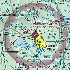
|
| Airport distance calculator |
|---|
|
|
| Sunrise and sunset |
|---|
|
Times for 12-Jul-2025
| | Local
(UTC-4) | | Zulu
(UTC) |
|---|
| Morning civil twilight | | 05:35 | | 09:35 |
| Sunrise | | 06:10 | | 10:10 |
| Sunset | | 21:24 | | 01:24 |
| Evening civil twilight | | 22:00 | | 02:00 |
|
| Current date and time |
|---|
| Zulu (UTC) | 12-Jul-2025 04:04:25 |
|---|
| Local (UTC-4) | 12-Jul-2025 00:04:25 |
|---|
|
| METAR |
|---|
| KCAD | 120355Z AUTO 13003KT 10SM FEW055 21/20 A2992 RMK AO2 402790140
|
|
| TAF |
|---|
KTVC
28nm N | 111736Z 1118/1218 05010KT P6SM SCT060 SCT140 FM112200 05010KT P6SM VCSH BKN050 FM120200 VRB04KT P6SM VCSH SCT040 FM120600 VRB04KT P6SM VCTS SCT005 BKN010CB FM121200 18010G20KT 3SM -RA VCTS SCT005 BKN040CB
|
|
| NOTAMs |
|---|
NOTAMs are issued by the DoD/FAA and will open in a separate window not controlled by AirNav.
|
|


