FAA INFORMATION EFFECTIVE 30 OCTOBER 2025
Location
| FAA Identifier: | CID |
| Lat/Long: | 41-53-04.9000N 091-42-38.9000W
41-53.081667N 091-42.648333W
41.8846944,-91.7108056
(estimated) |
| Elevation: | 869.3 ft. / 265.0 m (surveyed) |
| Variation: | 02E (1985) |
| From city: | 6 miles SW of CEDAR RAPIDS, IA |
| Time zone: | UTC -6 (UTC -5 during Daylight Saving Time) |
| Zip code: | 52404 |
Airport Operations
| Airport use: | Open to the public |
| Activation date: | 12/1944 |
| Control tower: | yes |
| ARTCC: | CHICAGO CENTER |
| FSS: | FORT DODGE FLIGHT SERVICE STATION |
| NOTAMs facility: | CID (NOTAM-D service available) |
| Attendance: | MON-FRI 0500-2330, ALL SAT-SUN 0500-2330 |
| Wind indicator: | lighted |
| Segmented circle: | no |
| Lights: | WHEN TWR CLSD ACTVT MALSR RWY 09, 27 & 31; PAPI RWY 09, 13 & 27; VASI RWY 31; HIRL RWY 09/27; MIRL RWY 13/31; TWY LGTS - CTAF. |
| Beacon: | white-green (lighted land airport)
Operates sunset to sunrise. |
| Fire and rescue: | ARFF index B |
| Airline operations: | INDEX C LEVEL ARFF AVBL; 48 HR PPR - 319-731-5722. |
Airport Communications
| CTAF: | 118.7 |
| UNICOM: | 122.95 |
| ATIS: | 124.15 |
| WX ASOS: | PHONE 319-558-5153 |
| CEDAR RAPIDS GROUND: | 121.6 [0500-2330] |
| CEDAR RAPIDS TOWER: | 118.7 266.8 [0500-2330] |
| CEDAR RAPIDS APPROACH: | 119.7 ;091-269 134.05 ;270-090 266.8 [0500-2330] |
| CHICAGO ARTCC APPROACH: | 119.05 [2330-0500] |
| CEDAR RAPIDS DEPARTURE: | 119.7 ;091-269 134.05 ;270-090 266.8 [0500-2330] |
| CLEARANCE DELIVERY: | 125.45 |
| CLASS C: | 119.7 ;091-269 134.05 ;270-090 266.8 |
| IC: | 118.7 119.7 ;091-269 |
| WX ASOS at IOW (16 nm SE): | 128.075 (319-339-9491) |
- APCH/DEP SVC PRVDD BY CHICAGO ARTCC ON FREQS 132.8/328.4 (CEDAR RAPIDS RCAG) WHEN APCH CTL CLSD.
Nearby radio navigation aids
| VOR radial/distance | | VOR name | | Freq | | Var |
|---|
| CIDr088/3.4 | | CEDAR RAPIDS VOR/DME | | 114.10 | | 05E |
| IOWr344/22.4 | | IOWA CITY VOR/DME | | 116.20 | | 05E |
Airport Services
| Fuel available: | 100LL JET-A
100LL:SELF SVC; W OF GA APRON. |
| Parking: | hangars and tiedowns |
| Airframe service: | MAJOR |
| Powerplant service: | MAJOR |
| Bottled oxygen: | HIGH/LOW |
| Bulk oxygen: | HIGH/LOW |
Runway Information
Runway 9/27
| Dimensions: | 8600 x 150 ft. / 2621 x 46 m |
| Surface: | concrete/grooved, in excellent condition |
| Weight bearing capacity: | | PCN 67 /R/B/W/T | | Single wheel: | 120.0 | | Double wheel: | 227.0 | | Double tandem: | 360.0 |
|
| Runway edge lights: | high intensity |
| Operational restrictions: | RWY 27 CALM WIND RWY. |
| RUNWAY 9 | | RUNWAY 27 |
| Latitude: | 41-53.078995N | | 41-53.056280N |
| Longitude: | 091-43.750102W | | 091-41.855458W |
| Elevation: | 854.0 ft. | | 859.8 ft. |
| Traffic pattern: | left | | left |
| Runway heading: | 089 magnetic, 091 true | | 269 magnetic, 271 true |
| Displaced threshold: | no | | 425 ft. |
| Declared distances: | TORA:8600 TODA:8600 ASDA:8175 LDA:8175 | | TORA:8600 TODA:8600 ASDA:8600 LDA:8175 |
| Markings: | precision, in good condition | | precision, in good condition |
| Visual slope indicator: | 4-light PAPI on right (3.00 degrees glide path) | | 4-light PAPI on left (3.00 degrees glide path) |
| RVR equipment: | touchdown, rollout | | touchdown, rollout |
| Approach lights: | MALSR: 1,400 foot medium intensity approach lighting system with runway alignment indicator lights | | MALSR: 1,400 foot medium intensity approach lighting system with runway alignment indicator lights |
| Runway end identifier lights: | | | no |
| Touchdown point: | yes, no lights | | yes, no lights |
| Instrument approach: | ILS | | ILS/DME |
| Obstructions: | none | | 14 ft. rr, 740 ft. from runway, 39:1 slope to clear |
Runway 13/31
| Dimensions: | 6200 x 150 ft. / 1890 x 46 m |
| Surface: | concrete/grooved, in good condition |
| Weight bearing capacity: | | PCN 73 /R/B/W/T | | Single wheel: | 120.0 | | Double wheel: | 172.0 | | Double tandem: | 360.0 |
|
| Runway edge lights: | medium intensity |
| RUNWAY 13 | | RUNWAY 31 |
| Latitude: | 41-53.467050N | | 41-52.733558N |
| Longitude: | 091-42.908085W | | 091-41.958133W |
| Elevation: | 869.3 ft. | | 847.6 ft. |
| Traffic pattern: | left | | left |
| Runway heading: | 134 magnetic, 136 true | | 314 magnetic, 316 true |
| Declared distances: | TORA:6200 TODA:6200 ASDA:6200 LDA:6200 | | TORA:6200 TODA:6200 ASDA:6200 LDA:6200 |
| Markings: | nonprecision, in good condition | | nonprecision, in good condition |
| Visual slope indicator: | 4-light PAPI on left (3.00 degrees glide path) | | 4-box VASI on left (3.00 degrees glide path) |
| Approach lights: | | | MALSR: 1,400 foot medium intensity approach lighting system with runway alignment indicator lights |
| Runway end identifier lights: | yes | | |
| Touchdown point: | yes, no lights | | yes, no lights |
Airport Ownership and Management from official FAA records
| Ownership: | Publicly-owned |
| Owner: | CITY OF CEDAR RAPIDS
101 FIRST STREET SE
CEDAR RAPIDS, IA 52401
Phone 319-362-3131 |
| Manager: | MARTIN LENSS
2515 ARTHUR COLLINS PKWY SW
CEDAR RAPIDS, IA 52404-8952
Phone 319-731-5711 |
Additional Remarks
| - | BIRDS ON & INVOF ARPT. |
| - | WHEN ATCT IS CLSD & DURG SNOW & ICE ALL ARR & DEP ANNC INTNS ON CTAF 5 MINS BFR RWY USE. PAEW SN & ICE REMOVAL MNT CTAF. |
| - | TWY D IS NON MOV SE OF ACES ROAD. TRML RAMP NON MOV; CALL FOR PUSH BACK NOT RQRD. |
| - | FUEL SVC AFT HR - 319-366-1925. |
| - | FOR CD IF UNA TO CTC ON FSS FREQ, CTC CHICAGO ARTCC AT 630-906-8921. |
| - | GATE 5 & AREA N/NW CLSD. |
Instrument Procedures
NOTE: All procedures below are presented as PDF files. If you need a reader for these files, you should download the free Adobe Reader.NOT FOR NAVIGATION. Please procure official charts for flight.
FAA instrument procedures published for use from 30 October 2025 at 0901Z to 27 November 2025 at 0900Z.
IAPs - Instrument Approach Procedures |
|---|
| ILS OR LOC RWY 09 | |
download (311KB) |
| ILS OR LOC RWY 27 | |
download (295KB) |
| RNAV (GPS) RWY 09 | |
download (338KB) |
| RNAV (GPS) RWY 13 | |
download (226KB) |
| RNAV (GPS) RWY 27 | |
download (286KB) |
| RNAV (GPS) RWY 31 | |
download (241KB) |
| NOTE: Special Alternate Minimums apply | |
download (125KB) |
| NOTE: Special Take-Off Minimums/Departure Procedures apply | |
download (158KB) |
Other nearby airports with instrument procedures:
C17 - Marion Airport (12 nm NE)
KIOW - Iowa City Municipal Airport (16 nm SE)
KVTI - Vinton Veterans Memorial Airpark (24 nm NW)
KTZT - Belle Plaine Municipal Airport (26 nm W)
8C4 - Mathews Memorial Airport (26 nm E)
|
|

Road maps at:
MapQuest
Bing
Google
| Aerial photo |
|---|
WARNING: Photo may not be current or correct
 Photo by Ron Plante
Photo taken 04-Sep-2018
looking northeast.
Photo by Ron Plante
Photo taken 04-Sep-2018
looking northeast.
Do you have a better or more recent aerial photo of The Eastern Iowa Airport that you would like to share? If so, please send us your photo.
|
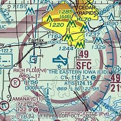
| Sectional chart |
|---|
|
 Download PDF
of official airport diagram from the FAA
| Airport distance calculator |
|---|
|
|
| Sunrise and sunset |
|---|
|
Times for 25-Nov-2025
| | Local
(UTC-6) | | Zulu
(UTC) |
|---|
| Morning civil twilight | | 06:39 | | 12:39 |
| Sunrise | | 07:09 | | 13:09 |
| Sunset | | 16:38 | | 22:38 |
| Evening civil twilight | | 17:09 | | 23:09 |
|
| Current date and time |
|---|
| Zulu (UTC) | 25-Nov-2025 18:57:11 |
|---|
| Local (UTC-6) | 25-Nov-2025 12:57:11 |
|---|
|
| METAR |
|---|
| KCID | 251852Z 21010KT 5SM BR OVC006 11/10 A2974 RMK AO2 CIG 005V010 SLP073 T01110100
|
KIOW
17nm SE | 251852Z AUTO 21008KT 4SM HZ OVC005 11/08 A2977 RMK AO2 CIG 004V008 SLP083 T01110083
|
|
| TAF |
|---|
| KCID | 251724Z 2518/2618 23008KT 6SM BR OVC005 TEMPO 2518/2520 3SM BR OVC003 FM252100 22012KT P6SM OVC015 PROB30 2521/2524 5SM -SHRA BR OVC010 FM260000 27015G25KT P6SM OVC030 FM260400 29020G35KT P6SM OVC015
|
|
| NOTAMs |
|---|
NOTAMs are issued by the DoD/FAA and will open in a separate window not controlled by AirNav.
|
|


