FAA INFORMATION EFFECTIVE 09 JULY 2026
Location
| FAA Identifier: | DAY |
| Lat/Long: | 39-54-08.1080N 084-13-09.8840W
39-54.135133N 084-13.164733W
39.9022522,-84.2194122
(estimated) |
| Elevation: | 1009.1 ft. / 307.6 m (surveyed) |
| Variation: | 06W (2020) |
| From city: | 9 miles N of DAYTON, OH |
| Time zone: | UTC -4 (UTC -5 during Standard Time) |
| Zip code: | 45377 |
Airport Operations
| Airport use: | Open to the public |
| Activation date: | 10/1937 |
| Control tower: | yes |
| ARTCC: | INDIANAPOLIS CENTER |
| FSS: | DAYTON FLIGHT SERVICE STATION |
| NOTAMs facility: | DAY (NOTAM-D service available) |
| Attendance: | CONTINUOUS |
| Wind indicator: | lighted |
| Segmented circle: | no |
| Lights: | SS-SR |
| Beacon: | white-green (lighted land airport)
Operates sunset to sunrise. |
| Fire and rescue: | ARFF index B |
| International operations: | customs landing rights airport |
Airport Communications
| UNICOM: | 122.95 |
| ATIS: | 125.8 |
| WX ASOS: | PHONE 937-419-1421 |
| DAYTON TOWER GROUND: | 121.9 |
| DAYTON TOWER TOWER: | 119.9 257.7 |
| COLUMBUS APPROACH: | 118.85 ;091-180 134.45 ;181-090 |
| COLUMBUS DEPARTURE: | 118.85 ;091-180 134.45 ;181-090 |
| CLEARANCE DELIVERY: | 121.75 |
| CLASS C: | 118.85 ;091-180 134.45 ;181-090 |
| DANEI STAR: | 134.45 |
| EMERG: | 121.5 243.0 |
| WX AWOS-3 at GDK (16 nm SE): | 118.525 (937-372-4668) |
| WX AWOS-3PT at SGH (18 nm E): | 134.975 (937-324-4532) |
| WX ASOS at MGY (19 nm S): | 118.375 (937-885-2171) |
- COMMUNICATIONS PRVDD BY DAYTON RADIO ON FREQS 122.1R/114.5T (DAYTON RCO).
Nearby radio navigation aids
| VOR radial/distance | | VOR name | | Freq | | Var |
|---|
| DQNr131/10.7 | | DAYTON VOR/DME | | 114.50 | | 01W |
| RODr204/24.5 | | ROSEWOOD VORTAC | | 117.50 | | 05W |
| MXQr330/34.3 | | MIDWEST VOR/DME | | 112.90 | | 04W |
| NDB name | | Hdg/Dist | | Freq | | Var | | ID |
|---|
| BRUNY | | 064/6.3 | | 315 | | 06W | | AT | .- - |
Airport Services
| Fuel available: | 100 JET-A |
| Parking: | hangars |
| Airframe service: | MAJOR |
| Powerplant service: | MAJOR |
| Bottled oxygen: | NONE |
| Bulk oxygen: | HIGH |
Runway Information
Runway 6L/24R
| Dimensions: | 10901 x 150 ft. / 3323 x 46 m |
| Surface: | asphalt/concrete/grooved, in good condition
NE 1400 FT CONC, SW 9501 FT ASPH. |
| Weight bearing capacity: | | Single wheel: | 100.0 | | Double wheel: | 210.0 | | Double tandem: | 583.0 | | Dual double tandem: | 870.0 |
|
| Runway edge lights: | high intensity |
| RUNWAY 6L | | RUNWAY 24R |
| Latitude: | 39-53.706495N | | 39-54.727507N |
| Longitude: | 084-14.761070W | | 084-12.843587W |
| Elevation: | 997.9 ft. | | 995.6 ft. |
| Traffic pattern: | left | | left |
| Runway heading: | 061 magnetic, 055 true | | 241 magnetic, 235 true |
| Declared distances: | TORA:10900 TODA:10900 ASDA:10900 LDA:10900 | | TORA:10900 TODA:10900 ASDA:10900 LDA:10900 |
| Markings: | precision, in good condition | | precision, in good condition |
| Visual slope indicator: | 4-light PAPI on left (3.00 degrees glide path) | | 4-light PAPI on left (3.00 degrees glide path) |
| RVR equipment: | touchdown, midfield, rollout | | touchdown, midfield, rollout |
| Approach lights: | ALSF2: standard 2,400 foot high intensity approach lighting system with centerline sequenced flashers (category II or III) | | MALSR: 1,400 foot medium intensity approach lighting system with runway alignment indicator lights |
| Runway end identifier lights: | no | | no |
| Centerline lights: | yes | | yes |
| Touchdown point: | yes, lighted | | yes, no lights |
| Instrument approach: | ILS | | ILS/DME |
| Obstructions: | none | | 75 ft. tree, 3417 ft. from runway, 197 ft. right of centerline, 42:1 slope to clear |
Runway 18/36
| Dimensions: | 8502 x 150 ft. / 2591 x 46 m |
| Surface: | asphalt/grooved, in good condition |
| Weight bearing capacity: | | Single wheel: | 100.0 | | Double wheel: | 210.0 | | Double tandem: | 583.0 | | Dual double tandem: | 870.0 |
|
| Runway edge lights: | high intensity |
| RUNWAY 18 | | RUNWAY 36 |
| Latitude: | 39-55.039203N | | 39-53.639433N |
| Longitude: | 084-12.723042W | | 084-12.675990W |
| Elevation: | 990.7 ft. | | 1007.2 ft. |
| Traffic pattern: | left | | left |
| Runway heading: | 185 magnetic, 179 true | | 005 magnetic, 359 true |
| Declared distances: | TORA:8502 TODA:8502 ASDA:8502 LDA:8502 | | TORA:8502 TODA:8502 ASDA:8502 LDA:8502 |
| Markings: | precision, in good condition | | precision, in good condition |
| Visual slope indicator: | | | 4-light PAPI on left (3.00 degrees glide path) |
| RVR equipment: | touchdown | | |
| Approach lights: | MALSR: 1,400 foot medium intensity approach lighting system with runway alignment indicator lights | | |
| Runway end identifier lights: | | | yes |
| Touchdown point: | yes, no lights | | yes, no lights |
| Instrument approach: | ILS | | |
| Obstructions: | 56 ft. trees, 2636 ft. from runway, 185 ft. right of centerline, 43:1 slope to clear | | 41 ft. trees, 1050 ft. from runway, 20:1 slope to clear |
Runway 6R/24L
| Dimensions: | 7285 x 150 ft. / 2220 x 46 m |
| Surface: | concrete/grooved, in good condition |
| Weight bearing capacity: | | Single wheel: | 100.0 | | Double wheel: | 210.0 | | Double tandem: | 583.0 | | Dual double tandem: | 870.0 |
|
| Runway edge lights: | high intensity |
| RUNWAY 6R | | RUNWAY 24L |
| Latitude: | 39-53.433085N | | 39-54.115173N |
| Longitude: | 084-13.394158W | | 084-12.112622W |
| Elevation: | 1005.0 ft. | | 1001.1 ft. |
| Traffic pattern: | left | | left |
| Runway heading: | 061 magnetic, 055 true | | 241 magnetic, 235 true |
| Declared distances: | TORA:7285 TODA:7285 ASDA:7001 LDA:7001 | | TORA:7285 TODA:7285 ASDA:7001 LDA:7001 |
| Markings: | precision, in good condition | | precision, in good condition |
| Visual slope indicator: | 4-light PAPI on left (3.00 degrees glide path) | | 4-light PAPI on left (3.00 degrees glide path) |
| RVR equipment: | | | touchdown |
| Approach lights: | | | MALSR: 1,400 foot medium intensity approach lighting system with runway alignment indicator lights |
| Runway end identifier lights: | yes | | no |
| Touchdown point: | yes, no lights | | yes, no lights |
| Instrument approach: | | | ILS/DME |
| Obstructions: | 51 ft. tree, 1230 ft. from runway, 517 ft. right of centerline, 20:1 slope to clear | | 25 ft. pole, 1194 ft. from runway, 633 ft. right of centerline, 39:1 slope to clear |
Airport Ownership and Management from official FAA records
| Ownership: | Publicly-owned |
| Owner: | CITY OF DAYTON, OHIO
101 W 3RD ST
DAYTON, OH 45402-1859
Phone 937-333-3333 |
| Manager: | DANIEL J ZENK
3600 TERMINAL DR STE 300
VANDALIA, OH 45377-1095
Phone 937-454-8214 |
Additional Remarks
| A39-18/36 | PCR VALUE: 500/F/C/X/T |
| A39-06R/24L | PCR VALUE: 608/R/C/W/T |
| A39-06L/24R | PCR VALUE: 608/R/C/W/T |
| - | SNC RAMP NORTH OF RWY 06L/24R EDGE LGTS NSTD. |
| - | TWY W SIGN LGTS OTS. |
| - | APN HOLD PAD FOR RWY 06L CLSD DLY 2200-0600. |
| - | RUNUPS PROHIBITED ON RWY 24L HOLD PAD. |
| - | TWY Z, TWY T, & TWY S BTN RWY 06L/24R & TWY W CLSD INDEFLY. |
| - | DEER, COYOTES, BIRDS, & WATERFOWL ON & INVOF ARPT. |
| - | TWY C BTN TWY N & TWY Z NOT AVBL FOR GROUP IV & GTR ACFT. TWY K, TWY H, TWY J, & TWY L NOT AVBL FOR GROUP IV & GTR ACFT. |
| - | TWY M NORTH OF RWY 06L/24R & TWY W CLSD TO ACR ACFT; ALL OTR ACFT 24 HR PPR 937-454-2010. |
| - | TWY M NORTH OF RWY 06L/24R & TWY W EDGE LGTS NSTD. |
Instrument Procedures
NOTE: All procedures below are presented as PDF files. If you need a reader for these files, you should download the free Adobe Reader.NOT FOR NAVIGATION. Please procure official charts for flight.
FAA instrument procedures published for use from 09 July 2026 at 0901Z to 06 August 2026 at 0900Z.
STARs - Standard Terminal Arrivals |
|---|
| DANEI THREE **NEW** | |
download (157KB) |
IAPs - Instrument Approach Procedures |
|---|
| ILS OR LOC RWY 06L | |
download (262KB) |
| ILS OR LOC RWY 18 **CHANGED** | |
download (231KB) |
| ILS OR LOC RWY 24L | |
download (268KB) |
| ILS OR LOC RWY 24R | |
download (257KB) |
| ILS RWY 06L (CAT II - III) | |
download (225KB) |
| RNAV (RNP) Y RWY 06L | |
download (251KB) |
| RNAV (RNP) Y RWY 24R | |
download (229KB) |
| RNAV (GPS) RWY 06R | |
download (224KB) |
| RNAV (GPS) RWY 18 | |
download (234KB) |
| RNAV (GPS) RWY 24L | |
download (241KB) |
| RNAV (GPS) RWY 36 **CHANGED** | |
download (196KB) |
| RNAV (GPS) Z RWY 06L | |
download (250KB) |
| RNAV (GPS) Z RWY 24R | |
download (235KB) |
| NOTE: Special Alternate Minimums apply | |
download (61KB) |
Departure Procedures |
|---|
| DAYTON NINE **NEW** | |
2 pages:
[1] [2] (252KB) |
| NOTE: Special Take-Off Minimums/Departure Procedures apply | |
download (286KB) |
Other nearby airports with instrument procedures:
3I7 - Dayton/Phillipsburg Airport (8 nm W)
KFFO - Wright-Patterson Air Force Base (9 nm SE)
I73 - Moraine Air Park (13 nm S)
I17 - Piqua Airport/Hartzell Field (16 nm N)
KGDK - Greene County/Lewis A Jackson Regional Airport (16 nm SE)
KSGH - Springfield/Beckley Municipal Airport (18 nm E)
KMGY - Dayton/Wright Brothers Airport (19 nm S)
|
|
 |
 |
| CURRENT PRICES |
|---|
100LL
$7.99 |
Jet-A
$5.59 |
|
 |
 |
|
| 
|

Road maps at:
MapQuest
Bing
Google
| Aerial photo |
|---|
WARNING: Photo may not be current or correct
 Photo by Kyle Grimmonpre
Photo taken 21-Sep-2020
looking southeast from 24000 ft.
Photo by Kyle Grimmonpre
Photo taken 21-Sep-2020
looking southeast from 24000 ft.
Do you have a better or more recent aerial photo of James M Cox Dayton International Airport that you would like to share? If so, please send us your photo.
|
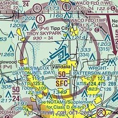
| Sectional chart |
|---|
|
CAUTION: Diagram may not be current
 Download PDF
of official airport diagram from the FAA
| Airport distance calculator |
|---|
|
|
| Sunrise and sunset |
|---|
|
Times for 13-Jul-2026
| | Local
(UTC-4) | | Zulu
(UTC) |
|---|
| Morning civil twilight | | 05:48 | | 09:48 |
| Sunrise | | 06:20 | | 10:20 |
| Sunset | | 21:05 | | 01:05 |
| Evening civil twilight | | 21:37 | | 01:37 |
|
| Current date and time |
|---|
| Zulu (UTC) | 14-Jul-2026 03:25:04 |
|---|
| Local (UTC-4) | 13-Jul-2026 23:25:04 |
|---|
|
| METAR |
|---|
| KDAY | 140256Z 03003KT 10SM FEW250 23/17 A3019 RMK AO2 SLP216 T02330167 51013 $
|
KFFO
10nm SE | 140255Z AUTO 00000KT 10SM CLR 24/21 A3016 RMK AO2 SLP208 T02390210 52014
|
KMGY
18nm S | 140253Z AUTO 05003KT 10SM CLR 23/21 A3016 RMK AO2 SLP206 T02330211 51009
|
KSGH
19nm E | 140256Z AUTO 00000KT 10SM CLR 22/21 A3019 RMK AO2 SLP218 T02220206 51012
|
|
| TAF |
|---|
| KDAY | 131721Z 1318/1418 05007KT P6SM FEW250 FM140100 VRB04KT P6SM SKC
|
KFFO
10nm SE | 131900Z 1319/1501 05009KT 9999 SCT037 SCT250 QNH3010INS BECMG 1322/1323 VRB06KT 9999 FEW250 QNH3011INS BECMG 1415/1416 12006KT 9999 FEW040 SCT250 QNH3009INS TX31/1320Z TN19/1411Z
|
|
| NOTAMs |
|---|
NOTAMs are issued by the DoD/FAA and will open in a separate window not controlled by AirNav.
|
|


