FAA INFORMATION EFFECTIVE 15 MAY 2025
Location
| FAA Identifier: | EDE |
| Lat/Long: | 36-01-42.9240N 076-34-11.1630W
36-01.715400N 076-34.186050W
36.0285900,-76.5697675
(estimated) |
| Elevation: | 18.7 ft. / 5.7 m (surveyed) |
| Variation: | 10W (2000) |
| From city: | 3 miles SE of EDENTON, NC |
| Time zone: | UTC -4 (UTC -5 during Standard Time) |
| Zip code: | 27932 |
Airport Operations
| Airport use: | Open to the public |
| Activation date: | 06/1943 |
| Control tower: | no |
| ARTCC: | WASHINGTON CENTER |
| FSS: | RALEIGH FLIGHT SERVICE STATION |
| NOTAMs facility: | EDE (NOTAM-D service available) |
| Attendance: | 0800-1700
FOR AFTER HOURS SERVICE CALL 252-217-4975. |
| Wind indicator: | lighted |
| Segmented circle: | yes |
| Lights: | PAPI RYS 01& 19 OPER CONT. ACTVT MIRL RY 1/19 AND REIL RYS 01 & 19 - CTAF. |
| Beacon: | white-green (lighted land airport)
Operates sunset to sunrise. |
Airport Communications
| CTAF/UNICOM: | 123.0 |
| WX AWOS-3: | 118.275 (252-482-0757) |
- APCH/DEP SVC PRVDD BY WASHINGTON ARTCC (ZDC) ON 123.85/279.65 (NEW BERN RCAG).
Nearby radio navigation aids
| VOR radial/distance | | VOR name | | Freq | | Var |
|---|
| ECGr241/23.5 | | ELIZABETH CITY VOR/DME | | 115.75 | | 07W |
| CVIr154/25.3 | | COFIELD VORTAC | | 114.60 | | 09W |
| NDB name | | Hdg/Dist | | Freq | | Var | | ID |
|---|
| WOODVILLE | | 233/19.3 | | 254 | | 10W | | LLW | .-.. .-.. .-- |
Airport Services
| Fuel available: | 100LL JET-A1+
A1+:JET A TRUCK AVAILABLE WITH SINGLE POINT AND OVER THE WING FILLING
100LL:AFTER HRS SELF SERVICE FUEL FOR 100LL AND A1+ AVBL WITH CREDIT CARD. |
| Parking: | hangars and tiedowns |
| Airframe service: | MAJOR |
| Powerplant service: | MAJOR |
| Bottled oxygen: | NONE |
| Bulk oxygen: | NONE |
Runway Information
Runway 1/19
| Dimensions: | 6001 x 100 ft. / 1829 x 30 m
RY 01/19 HAS 1500 FT STOPWAY AT N END & 500 FT STOPWAY AT S END. |
| Surface: | asphalt, in good condition |
| Weight bearing capacity: | | Single wheel: | 60.0 | | Double wheel: | 80.0 |
|
| Runway edge lights: | medium intensity |
| RUNWAY 1 | | RUNWAY 19 |
| Latitude: | 36-01.220892N | | 36-02.209893N |
| Longitude: | 076-34.185113W | | 076-34.186980W |
| Elevation: | 17.5 ft. | | 17.3 ft. |
| Traffic pattern: | left | | left |
| Runway heading: | 010 magnetic, 000 true | | 190 magnetic, 180 true |
| Markings: | nonprecision, in good condition | | precision, in good condition |
| Visual slope indicator: | 2-light PAPI on left (3.00 degrees glide path) | | 2-light PAPI on right (3.00 degrees glide path) |
| Runway end identifier lights: | yes | | yes |
| Touchdown point: | yes, no lights | | yes, no lights |
| Instrument approach: | | | ILS/DME |
| Obstructions: | 78 ft. trees, 2182 ft. from runway, 272 ft. left of centerline, 25:1 slope to clear | | 36 ft. trees, 1131 ft. from runway, 561 ft. right of centerline, 25:1 slope to clear |
Airport Ownership and Management from official FAA records
| Ownership: | Publicly-owned |
| Owner: | TOWN OF EDENTON
PO BOX 300
EDENTON, NC 27932
Phone (252) 482-2155 |
| Manager: | HARRY DAVIS
113 AIRPORT ROAD
EDENTON, NC 27932
Phone 252-482-4664 |
Additional Remarks
| - | SEASONAL PROBLEM WITH BIRDS & DEER ON & INVOF ARPT. |
| - | TWYS SERVING RY 01/19 HAVE GREEN CNTRLN REFLECTORS AND NSTD SOLAR LGTS. |
| - | FOR CD CTC WASHINGTON ARTCC AT 703-771-3587. |
Instrument Procedures
NOTE: All procedures below are presented as PDF files. If you need a reader for these files, you should download the free Adobe Reader.NOT FOR NAVIGATION. Please procure official charts for flight.
FAA instrument procedures published for use from 15 May 2025 at 0901Z to 13 June 2025 at 0900z.
IAPs - Instrument Approach Procedures |
|---|
| ILS OR LOC RWY 19 | |
download (292KB) |
| RNAV (GPS) RWY 01 | |
download (196KB) |
| RNAV (GPS) RWY 19 | |
download (293KB) |
| NOTE: Special Alternate Minimums apply | |
download (24KB) |
| NOTE: Special Take-Off Minimums/Departure Procedures apply | |
download (141KB) |
Other nearby airports with instrument procedures:
KPMZ - Plymouth Municipal Airport (16 nm SW)
KECG - Elizabeth City Coast Guard Air Station/Regional Airport (24 nm NE)
KMCZ - Martin County Airport (31 nm W)
KASJ - Tri-County Airport at Henry Joyner Field (33 nm NW)
KONX - Currituck County Regional Airport (35 nm NE)
|
|

Road maps at:
MapQuest
Bing
Google
| Aerial photo |
|---|
WARNING: Photo may not be current or correct
 Photo taken 22-Nov-2007
Do you have a better or more recent aerial photo of Northeastern Regional Airport that you would like to share? If so, please send us your photo.
|
| Sectional chart |
|---|
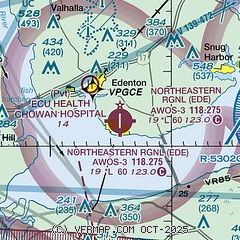
|
| Airport distance calculator |
|---|
|
|
| Sunrise and sunset |
|---|
|
Times for 16-May-2025
| | Local
(UTC-4) | | Zulu
(UTC) |
|---|
| Morning civil twilight | | 05:32 | | 09:32 |
| Sunrise | | 06:01 | | 10:01 |
| Sunset | | 20:05 | | 00:05 |
| Evening civil twilight | | 20:33 | | 00:33 |
|
| Current date and time |
|---|
| Zulu (UTC) | 17-May-2025 02:21:23 |
|---|
| Local (UTC-4) | 16-May-2025 22:21:23 |
|---|
|
| METAR |
|---|
| KEDE | 170200Z AUTO 23007KT 10SM CLR 27/25 A2983 RMK AO2 T02710253
|
|
| TAF |
|---|
KECG
24nm NE | 161723Z 1618/1718 25011KT P6SM SCT040 FM162300 24008KT P6SM VCSH SCT050 PROB30 1623/1703 VRB20G45KT 1SM +TSRA OVC035CB FM170600 20007KT P6SM SCT250 FM171100 23009KT P6SM BKN250 FM171500 24014G22KT P6SM SCT040
|
|
| NOTAMs |
|---|
NOTAMs are issued by the DoD/FAA and will open in a separate window not controlled by AirNav.
|
|


