FAA INFORMATION EFFECTIVE 22 JANUARY 2026
Location
| FAA Identifier: | FFZ |
| Lat/Long: | 33-27-39.0260N 111-43-41.9710W
33-27.650433N 111-43.699517W
33.4608406,-111.7283253
(estimated) |
| Elevation: | 1394 ft. / 424.9 m (surveyed) |
| Variation: | 12E (1990) |
| From city: | 5 miles NE of MESA, AZ |
| Time zone: | UTC -7 (year round; does not observe DST) |
| Zip code: | 85215 |
Airport Operations
| Airport use: | Open to the public |
| Activation date: | 12/1941 |
| Control tower: | yes |
| ARTCC: | ALBUQUERQUE CENTER |
| FSS: | PRESCOTT FLIGHT SERVICE STATION |
| NOTAMs facility: | FFZ (NOTAM-D service available) |
| Attendance: | AUG 16 - MAY 14 FRI-SUN 0530-1600, AUG 16 - MAY 14 MON-THUR 0530-1800, MAY 15 - AUG 15 FRI-SUN 0500-1530, MAY 15 - AUG 15 MON-THUR 0500-1800 |
| Pattern altitude: | 2702 ft. MSL
TPA FOR LIGHT ACFT 1006 FT AGL; TPA FOR LARGE & TURBINE-POWERED ACFT 1506 FT AGL; TPA 506 FT AGL FOR ROTORCRAFT. |
| Wind indicator: | lighted |
| Segmented circle: | yes |
| Lights: | ACTVT MIRL RWY 04L/22R; TWY LGTS - CTAF. WHEN ATCT CLSD MIRL RWY 04L/22R NA; MIRL RWY 04R/22L; TWY LGTS PRESET LOW INTST; INCR INTST - CTAF. |
| Beacon: | white-green (lighted land airport)
Operates sunset to sunrise. |
Airport Communications
| CTAF: | 124.6 |
| UNICOM: | 122.95 |
| ATIS: | 118.25 |
| WX ASOS: | PHONE 480-641-4111 |
| FALCON GROUND: | 121.3 [MAY 15-AUG 15 0530-2100, AUG 16-MAY14 0600-2100.] |
| FALCON TOWER: | 124.6 [MAY 15-AUG 15 0530-2100, AUG 16-MAY14 0600-2100.] |
| PHOENIX APPROACH: | 120.7 |
| PHOENIX DEPARTURE: | 120.7 |
| BLYTHE STAR: | 124.1 |
| DSERT STAR: | 120.7 |
| HUUTY STAR: | 124.9 |
| SUNSS STAR: | 124.1 |
| WX AWOS-3 at IWA (10 nm S): | 133.5 (480-988-9428) |
| WX AWOS-3PT at CHD (12 nm S): | PHONE 480-814-9952 |
| WX ASOS at SDL (13 nm NW): | PHONE 480-483-3049 |
| WX ASOS at PHX (14 nm W): | PHONE 602-551-6092 |
- EMERG FREQ 121.5 NOT AVBL AT ATCT.
- SAID IN USE. OPERATE TRANSPONDERS WITH ALTITUDE REPORTING MODE AND ADS-B (IF EQUIPPED) ENABLED ON ALL AIRPORT SURFACES.
Nearby radio navigation aids
| VOR radial/distance | | VOR name | | Freq | | Var |
|---|
| IWAr325/10.2 | | WILLIE VORTAC | | 113.30 | | 13E |
| PXRr070/12.2 | | PHOENIX VORTAC | | 115.60 | | 12E |
| TFDr003/35.7 | | STANFIELD VORTAC | | 114.80 | | 12E |
Airport Services
| Fuel available: | 100LL JET-A JET-A1+
A:SAF. |
| Parking: | tiedowns |
| Airframe service: | MAJOR |
| Powerplant service: | MAJOR |
| Bottled oxygen: | HIGH/LOW |
| Bulk oxygen: | HIGH/LOW |
Runway Information
Runway 4R/22L
| Dimensions: | 5100 x 100 ft. / 1554 x 30 m |
| Surface: | asphalt, in good condition |
| Weight bearing capacity: | | Single wheel: | 38.0 | | Double wheel: | 60.0 | | Double tandem: | 90.0 |
|
| Runway edge lights: | medium intensity |
| RUNWAY 4R | | RUNWAY 22L |
| Latitude: | 33-27.353998N | | 33-27.881167N |
| Longitude: | 111-44.045217W | | 111-43.263647W |
| Elevation: | 1365.6 ft. | | 1394.0 ft. |
| Traffic pattern: | left | | left
RIGHT TFC WHEN ATCT CLSD OR RWY 4L/22R IS CLSD. |
| Runway heading: | 039 magnetic, 051 true | | 219 magnetic, 231 true |
| Markings: | nonprecision, in good condition | | nonprecision, in good condition |
| Visual slope indicator: | 4-light PAPI on left (4.00 degrees glide path) | | 4-light PAPI on left (4.00 degrees glide path)
PAPI RWY 22L DOES NOT PRVD OBSTN CLNC BYD 4 NM FM THR. |
| Runway end identifier lights: | yes | | yes |
| Touchdown point: | yes, no lights | | yes, no lights |
| Obstructions: | 8 ft. road, 420 ft. from runway, 270 ft. left of centerline, 27:1 slope to clear | | none |
Runway 4L/22R
| Dimensions: | 3799 x 75 ft. / 1158 x 23 m |
| Surface: | asphalt, in good condition |
| Weight bearing capacity: | |
| Runway edge lights: | medium intensity |
| Operational restrictions: | CLSD WHEN ATCT CLSD. 150 FT X 95 FT BLAST PADS AVBL. |
| RUNWAY 4L | | RUNWAY 22R |
| Latitude: | 33-27.498027N | | 33-27.890962N |
| Longitude: | 111-44.051035W | | 111-43.468963W |
| Elevation: | 1365.7 ft. | | 1386.0 ft. |
| Traffic pattern: | left | | right |
| Runway heading: | 039 magnetic, 051 true | | 219 magnetic, 231 true |
| Markings: | basic, in good condition | | basic, in good condition |
| Visual slope indicator: | 2-light PAPI on left (4.00 degrees glide path) | | 2-light PAPI on left (4.00 degrees glide path) |
| Runway end identifier lights: | yes | | yes |
| Touchdown point: | yes, no lights | | yes, no lights |
Airport Ownership and Management from official FAA records
| Ownership: | Publicly-owned |
| Owner: | CITY OF MESA
4800 E FALCON DR
MESA, AZ 85215-2506
Phone 480-644-2450 |
| Manager: | CORINNE NYSTROM
4800 E FALCON DR.
MESA, AZ 85215
Phone 480-644-2450 |
Additional Remarks
| A30A-04L | RWY 04L CALM WIND RWY. |
| - | NOISE ABATEMENT PROC IN EFCT; QUIET HR 0500-1230Z; RWY 04L & 04R PREFFERED; TGL 0500-1230Z NA; CLMB AT VY UNTIL 2400 FT MSL; MNTN TFC PAT 3/4 MI FM RWY END. |
| - | WHEN ATCT CLSD, FOR CD CTC PHOENIX APPROACH AT 602-306-2565. |
| - | TRNG OPS RWY 04L/22R WHEN PSBL; TRNG OPS NA 2200-0530. |
| - | 2786 FT MSL UNLGTD MT 5 MI E. RISING TRRN NE. |
| - | CTN: HELI 1 MI N; DO NOT MISTAKE FOR RWY. |
| - | TWY G CLSD WHEN ATCT CLSD. |
| - | TURB PSBL BLW 500 FT NEAR TEST SITE 1.5 MI N. |
| - | TRML APRON LMTD TO 45000 LB GWT SINGLE WHEEL OR 75000 LB GWT DUAL WHEEL. |
| - | FIXED WING & ROTORCRAFT TRNG, BIRDS & WILDLIFE ON & INVOF ARPT. |
Instrument Procedures
NOTE: All procedures below are presented as PDF files. If you need a reader for these files, you should download the free Adobe Reader.NOT FOR NAVIGATION. Please procure official charts for flight.
FAA instrument procedures published for use from 22 January 2026 at 0901Z to 19 February 2026 at 0900z.
STARs - Standard Terminal Arrivals |
|---|
| ARLIN FOUR | |
download (285KB) |
| BLYTHE FIVE | |
download (255KB) |
| DSERT TWO (RNAV) | |
2 pages:
[1] [2] (298KB) |
| HUUTY ONE (RNAV) | |
download (234KB) |
| SUNSS EIGHT | |
download (237KB) |
IAPs - Instrument Approach Procedures |
|---|
| RNAV (GPS) RWY 04L **CHANGED** | |
download (180KB) |
| RNAV (GPS) RWY 04R **CHANGED** | |
download (195KB) |
| RNAV (GPS)-B **CHANGED** | |
download (168KB) |
| NOTE: Special Alternate Minimums apply | |
download (120KB) |
Departure Procedures |
|---|
| SACAT THREE (RNAV) | |
download (154KB) |
|
|---|
| MESA ONE (OBSTACLE) | |
download (325KB) |
| NOTE: Special Take-Off Minimums/Departure Procedures apply | |
download (357KB) |
Other nearby airports with instrument procedures:
KIWA - Mesa Gateway Airport (10 nm S)
KCHD - Chandler Municipal Airport (12 nm S)
KSDL - Scottsdale Airport (13 nm NW)
P19 - Stellar Airpark (14 nm SW)
KPHX - Phoenix Sky Harbor International Airport (14 nm W)
|
|

Road maps at:
MapQuest
Bing
Google
| Aerial photo |
|---|
WARNING: Photo may not be current or correct
 Photo courtesy of Maricopa County (AZ) Assessors Office
Taken in August 2013
looking north.
Photo courtesy of Maricopa County (AZ) Assessors Office
Taken in August 2013
looking north.
Do you have a better or more recent aerial photo of Falcon Field Airport that you would like to share? If so, please send us your photo.
|
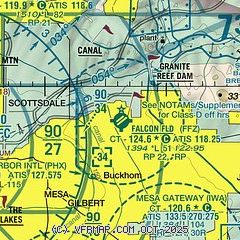
| Sectional chart |
|---|
|
CAUTION: Diagram may not be current
 Download PDF
of official airport diagram from the FAA
| Airport distance calculator |
|---|
|
|
| Sunrise and sunset |
|---|
|
Times for 08-Feb-2026
| | Local
(UTC-7) | | Zulu
(UTC) |
|---|
| Morning civil twilight | | 06:53 | | 13:53 |
| Sunrise | | 07:18 | | 14:18 |
| Sunset | | 18:04 | | 01:04 |
| Evening civil twilight | | 18:30 | | 01:30 |
|
| Current date and time |
|---|
| Zulu (UTC) | 08-Feb-2026 10:40:04 |
|---|
| Local (UTC-7) | 08-Feb-2026 03:40:04 |
|---|
|
| METAR |
|---|
KIWA
10nm S | 081015Z AUTO 11006KT 10SM CLR 12/01 A3019 RMK AO2 T01230014
|
KCHD
12nm S | 081015Z AUTO 00000KT 10SM CLR 13/04 A3017 RMK AO2 T01270036 $
|
KSDL
13nm NW | 080953Z AUTO 00000KT 10SM CLR 14/03 A3018 RMK AO2 SLP201 T01390028
|
KPHX
16nm W | 080951Z 00000KT 10SM CLR 17/02 A3015 RMK AO2 SLP196 T01670022
|
|
| TAF |
|---|
KIWA
10nm S | 080520Z 0806/0906 11006KT P6SM FEW200 FM081800 32005KT P6SM FEW200 FM090400 12006KT P6SM SKC AMD LTD TO CLD VIS AND WIND TIL 081200
|
KSDL
13nm NW | 080520Z 0806/0906 VRB03KT P6SM FEW200
|
KPHX
16nm W | 080520Z 0806/0912 VRB04KT P6SM FEW200 FM081000 09005KT P6SM FEW200 FM082200 30005KT P6SM FEW200 FM090600 11005KT P6SM SKC
|
|
| NOTAMs |
|---|
NOTAMs are issued by the DoD/FAA and will open in a separate window not controlled by AirNav.
|
|


